Saturday, October 24, 2009

"The Heliodoros stele" and the Maccabean Revolt

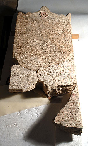
"The Heliodoros stele"- consisting of 28 lines inscribed on limestone is considered one of the most important ancient inscriptions found in Israel. Recently, three smaller fragments of a Greek inscription were found at an Israel Antiquities Authority excavation at Maresha.

Dr. Dov Gera determined that the fragments were actually the lower portion of "The Heliodoros stele". This discovery confirmed the assumption that the stele originally stood in one of the temples in Maresha- Beit Guvrin National Park today. It now can be determined that this royal stele originated in the city of Maresha.

The stele adds important archaeological evidence and historical context for understanding the period of time leading up to the Maccabean Revolt, an event celebrated each year on the holiday of Hanukah.


The Heliodoros Stele - with all of its pieces restored - photograph Peter Lenny, Israel Museum Jerusalem

This royal stone stele bears a proclamation by the Seleucid king, Seleucus IV (brother of Antiochus IV), and dates to 178 BCE. The contents of the stele shed light on the Seleucid government's involvement in local temples, mentioning an individual named Olympiodoros, the appointed "overseer" of the temples in Coele Syria – Phoenicia, including Judea. The order of the king was sent to Heliodorus, who was probably the same person mentioned in II Maccabees 3.

According to the story in Maccabees, Heliodorus, as the representative of King Seleucus IV, tried to steal the wealth from the Temple in Jerusalem but instead was severely beaten as a result of divine intervention. Three years later Seleucus IV was assassinated and was succeeded by his brother Antiochus IV, who was the ruler who according to II Maccabees eventually issued an edict of persecution against the Jewish people and desecrated the Temple in Jerusalem leading to the Maccabean Revolt.

Royal seal impressions discovered

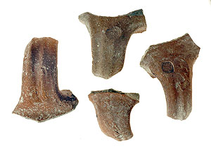
Royal seal impressions were discovered in excavations of the Israel Antiquities Authority at Umm Tuba, in the southern hills of Jerusalem.

Considering the limited area of the excavation and the rural nature of the structure that was revealed, the excavators were surprised to discover in it so many royal seal impressions that date to the reign of Hezekiah, King of Judah (end of the eighth century BCE). Four “LMLK” type impressions were discovered on handles of large jars that were used to store wine and oil in royal administrative centers. These were found together with the seal impressions of two high ranking officials named Ahimelekh ben Amadyahu and Yehokhil ben Shahar, who served in the kingdom’s government. The Yehokhil seal was stamped on one of the LMLK impressions before the jar was fired in a kiln and this is a very rare instance in which two such impressions appear together on a single handle.


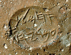
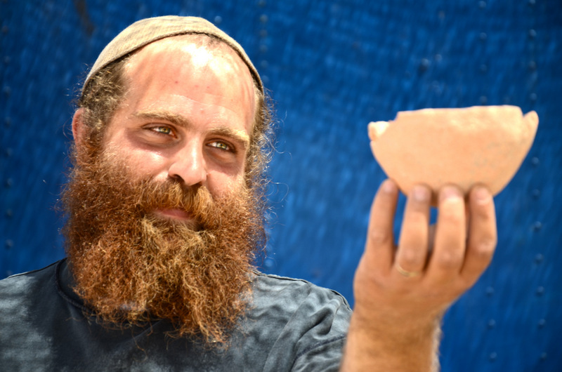
Another Hebrew inscription, 600 years later than the seal impressions of the Kingdom of Judah, was discovered on a fragment of a jar neck that dates to the Hasmonean period. An alphabetic sequence was engraved with a thin iron stylus below the vessel’s rim in Hebrew script that is characteristic of the beginning of the Hasmonean period (end of the second century BCE). The letters hay to yod and a small part of the letter kaf were preserved on the sherd. Similar inscriptions bearing alphabetic sequences were discovered in the past, usually on ostraca (inscriptions written in ink on pottery sherds) or engraved on ossuaries (stone receptacles in which human bones were buried). The alphabetic inscription that was discovered in this instance is unique and the significance of it requires further study: was this a “writing exercise” done by an apprentice scribe or should we ascribe it some magical importance?


The remains of the large building included several rooms arranged around a courtyard. Pits, agricultural installations and subterranean silos were hewn inside the courtyard. A potter’s kiln, a large columbarium cave in which there is a rock-hewn hiding refuge, pottery vessels, etc were also discovered inside the built complex. The pottery vessels that were recovered from the ruins of the building indicate it first dates to the end of the Iron Age (the First Temple period) in the eighth century BCE. Following its destruction, along with Jerusalem and all of Judah during the Babylonian conquest, Jews reoccupied it in the Hasmonean period (second century BCE) and it existed for another two hundred years until the destruction of the Second Temple. During the Byzantine period the place was reinhabited as part of the extensive rural settlement of monasteries and farmsteads in the region between Jerusalem and Bethlehem.

Some three years ago the impressive remains of a monastery from this period were excavated that together with the remains of the current excavation confirm the identification of the place as “Metofa”, which is mentioned in the writings of the church fathers in the Byzantine period. The name of the Arab village, “Umm Tuba” is therefore a derivation of Byzantine “Metofa”, which is Biblical “Netofa” and is mentioned as the place from which two of David’s heroes originated (2 Samuel 23:28-29).

City of David: Magnificent Roman Building

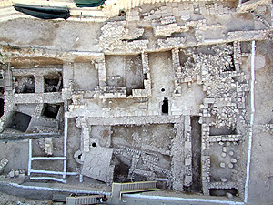
A spacious edifice from the Roman period (third century CE) – apparently a mansion that belonged to a wealthy individual – was recently exposed in the excavations the Israel Antiquities Authority is carrying out in the 'Givati Car Park' at the City of David, in the Walls Around Jerusalem National Park.


According to Dr. Doron Ben-Ami, the excavation director on behalf of the IAA, together with Yana Tchekhanovets, “Although we do not have the complete dimensions of the structure, we can cautiously estimate that the building covered an area of approximately 1,000 square meters. In the center of it was a large open courtyard surrounded by columns. Galleries were spread out between the rows of columns and the rooms that flanked the courtyard. The wings of the building rose to a height of two stories and were covered with tile roofs”.

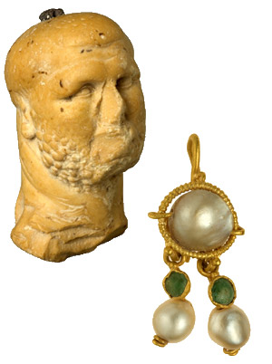
A large quantity of fresco fragments was discovered in the collapsed ruins from which the excavators deduced that some of the walls of the rooms were treated with plaster and decorated with colorful paintings. The painted designs that adorned the plastered walls consisted mostly of geometric and floral motifs. Its architectural richness, plan and particularly the artifacts that were discovered among its ruins bear witness to the unequivocal Roman character of the building. The most outstanding of these finds are a marble figurine in the image of a boxer and a gold earring inlaid with precious stones.


The building, which was constructed during the third century CE, was shaken by a tremor in the fourth century, the results of which are clearly apparently in the excavation area:the walls of the rooms caved-in and their stone collapse, which was piled high, covered the walls of the bottom floor, some of which still stand to a considerable height. Architectural elements such as columns and capitals, as well as mosaics and the large amount of fresco fragments that were used in the rooms of the second story were discovered inside the collapsed ruins. The coins that were discovered among the collapse and on the floors indicated the building’s ruins should be dated to circa 360 CE. It seems that what we have here is archaeological evidence of the results of the earthquake that struck our region in 363 CE.

Dr. Ben-Ami adds, “We know of no other buildings from the Roman period that were discovered in Israel which have a similar plan to that of the building from the City of David. The closest contemporary parallels to this structure are located in sites of the second-fourth century CE that were excavated in Syria. Edifices such as these are “urban mansions” from the Roman period that were discovered in Antioch, Apamea and Palmyra. If this parallel is correct, then in spite of its size and opulence, it seems that this building was used originally as a private residence”.

The exposure of the Roman building in the City of David is a significant contribution to our understanding of the extent of the construction in the Roman city in the third-fourth centuries CE. It constitutes extremely important archaeological evidence regarding the growth of the settlement at the end of the Roman period into the southern precincts of the city, and it shows that the prevailing supposition among scholars according to which the City of David hill remained outside the area of Roman settlement at the time of the Aelia Capitolina is no longer valid.

The Lod Mosaic And Its Builders


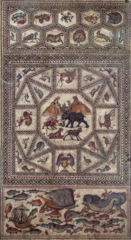
The 1,700 year old mosaic, which is one of the largest and most magnificent ever seen in Israel, was exposed in the city of Lod in 1996. It is a real archaeological gem that is extraordinarily well-preserved. It is c. 180 sq m in size. It is composed of colorful carpets that depict in great detail mammals, birds, fish, floral species, and sailing and merchant vessels that were in use at the time. It is believed the mosaic floor was part of a villa that belonged to a wealthy man in the Roman period.

Recently the conservators were surprised to discover that the builders of the beautiful mosaic left their personal mark there: while working on the plaster bedding which is done before attaching the mosaic, the artisans trod on it wearing sandals and in their bare feet.
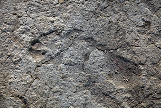


According to Jacques Neguer, head of the IAA Art Conservation Branch, “When removing a section of mosaic it is customary to clean its bedding, and that way study the material from which it is made and the construction stages. We look for drawings and sketches that the artists made in the plaster and marked where each of the tesserae will be placed. This is also what happened with the Lod mosaic: beneath a piece on which vine leaves are depicted, we discovered that the mosaic’s builders incised lines that indicate where the tesserae should be set, and afterwards, while cleaning the layer, we found the imprints of feet and sandals: sizes 34, 37, 42 and 44. At least one imprint of a sole resembles a modern sandal. Based on the concentration of foot and sandal prints it seems that the group of builders tamped the mortar in place with their feet”.


Neguer added, “The mosaic consists of three parts that different artists built, probably in different periods. There are different kinds of art here, and we can see that the hand that affixed the tesserae is different: a trained eye recognizes that the preparation which was done prior to the work is different. Besides the necessary professionalism, exposing the footprints is also the result of a lot of luck. It is not always possible to cut the layers of the mosaic precisely so that we discover such a clear picture of the plaster with the incising on it”.

Neguer states that, “the excitement here was great. It is fascinating to discover a 1,700 year old personal mark of people who are actually like us, who worked right here on the same mosaic. We feel the continuity of generations here”.

The hand and foot prints that were revealed will be removed from the area and will be conserved and returned to the site together with the mosaic, to the Shelby White and Leon Levy Lod Mosaic Archaeological Center.

The conservation of the site in Lod is meant to be a springboard that will boost tourism and a leverage that will alter the image of the city. The mosaic is located in the eastern part of Lod, next to the entrance at Ginnaton Junction. This intersection is easily reached from Ben Gurion Airport and from two of the country’s main highways: Highway 1, which connects Tel Aviv with Jerusalem, and Highway 6, which links the north of the country with the south. The site is situated between two streets: He-HalutzStreet, which leads to the marketplace and Struma Street, which leads to the city’s historic center. The location of the site next to the country’s main transportation arteries makes it highly accessible and will facilitate turning it into a site that is of interest to the entire country. The municipality, in cooperation with the Israel Antiquities Authority, plans to integrate it into a tourism circuit that will include a number of historic sites in the city.
Second Temple Period Stepped Street Discovered


A section of a stepped street paved in stone slabs, going south in the direction of the Shiloach Pool was discovered in excavations conducted by the Israel Antiquities Authority in the Shiloach Pool Excavation at the City of David in the Jerusalem Walls National Park. The excavations are conducted in cooperation with the Israel Nature and Parks Authority, funded by the Elad Foundation, under the auspices of Prof. Ronny Reich of Haifa University and Eli Shukron of the Israel Antiquities Authority.

The existence of this road has been known about for over one hundred years, since it was first discovered between 1894 and 1897 by Prof. Frederick J. Bliss and Archibald C. Dickey of the British Palestine Exploration Fund, and then covered and filled in at the end of their excavation. Other sections of this same road, to the north, have been excavated and covered over in the past, including during the excavations of Jones in 1937 and Kathleen Kenyon from 1961-1967.

This section of the stepped street was discovered at a distance of 550 meters south of the Temple Mount. The road represents the central thoroughfare of Jerusalem that ascended from the north-west corner of the Second Temple Shiloach Pool to the north.

According to Prof. Ronny Reich, "In the Second Temple Period, pilgrims would begin the ascent to the Temple from here. This is the southernmost tip of the road, of which a section has already been discovered along the western face of the Temple Mount."

The current excavation has been concentrated in a very narrow strip (1-2 meters in width) in the western sections of the road. Essentially, the excavation work removed the earth that had been filled in by previous excavators over the sections they already discovered. This section of road is built in the Second Temple style, which comprises alternating wide and narrow steps.

Further work must be done to clarify what the relationship was between the current excavated section and the section of the road and the drainage channel that were discovered nearby two years ago.

One of the Oldest Synagogues in the World


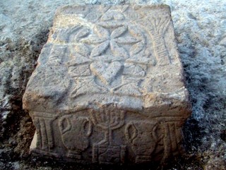
A synagogue from the Second Temple period (50 BCE-100 CE) was exposed in archaeological excavations the Israel Antiquities Authority is conducting at a site slated for the construction of a hotel on Migdal beach, in an area owned by the Ark New Gate Company. In the middle of the synagogue is a stone that is engraved with a seven-branched menorah (candelabrum), the likes of which have never been seen. The excavations were directed by archaeologists Dina Avshalom-Gorni and Arfan Najar of the Israel Antiquities Authority.

The main hall of synagogue is c. 120 square meters in area and its stone benches, which served as seats for the worshippers, were built up against the walls of the hall. Its floor was made of mosaic and its walls were treated with colored plaster (frescos). A square stone, the top and four sides of which are adorned with reliefs, was discovered in the hall. The stone is engraved with a seven-branched menorah set atop a pedestal with a triangular base, which is flanked on either side by an amphora (jars).

According to the excavation director, Dina Avshalom-Gorni of the Israel Antiquities Authority, “We are dealing with an exciting and unique find. This is the first time that a menorah decoration has been discovered from the days when the SecondTemple was still standing. This is the first menorah to be discovered in a Jewish context and that dates to the Second Temple period/beginning of the Early Roman period. We can assume that the engraving that appears on the stone, which the Israel Antiquities Authority uncovered, was done by an artist who saw the seven-branched menorah with his own eyes in the Temple in Jerusalem. The synagogue that was uncovered joins just six other synagogues in the world that are known to date to the SecondTemple period”.

According to the Minister of Culture and Sport, MK Limor Livnat, “This important find attests to the extensive Jewish settlement in the northern region at the time of the Temple. I am certain that the site will constitute an attraction for tourists from abroad and from Israel and will shed light on life in the Jewish settlement during the Second Temple period”.

Jose Miguel Abat, legal representative of "Ark New Gate" company, expressed his joy for the finding and said it reinforces the company's intention to establish a center of dialogue and respect between the different religions and cultures. Abat said that "we are sure this finding and the planned center will attract tourists and visitors from Israel and from around the World".


The synagogue is located in Migdal (‘Magdala’ in Aramaic), which is mentioned in Jewish sources. Migdal played an important role during the Great Revolt and was actually the main base of Yosef Ben Matityahu (Josephus Flavius), commander of the rebellion in the Galilee. Migdal also continued to resist the Romans after both the Galilee and Tiberias had surrendered. ‘Magdala’ is mentioned in Christian sources as the place whence Mary Magdalene came, one of the women who accompanied Jesus and the apostles and who Christian tradition has sanctified. After it was conquered by the Romans, the city was destroyed and many of its residents were killed. At the end of the Second Temple period Migdal was an administrative center of the western basin of the Sea of Galilee. Until the founding of Tiberias in the year 19 CE, Migdal was the only important settlement along the shore of the Sea of Galilee.

3,700 Year Old Fortification in the City of David

An Enormous 3,700 Year Old Fortification was Exposed in the City of David


A huge fortification more than 3,700 years old, which is ascribed to the Canaanites (Middle Bronze Age 2), was uncovered in archaeological excavations the Israel Antiquities Authority is currently conducting in the “Walls Around Jerusalem" ational Park in the City of David, with funding provided by the ‘Ir David' Foundation.

According to the director of the excavation, Professor Ronny Reich of the University of Haifa, together with Eli Shukron on behalf of the Israel Antiquities Authority, “This is the most massive wall that has ever been uncovered in the City of David, and it rises to a height of 8 meters. We are dealing with a gigantic fortification, from the standpoint of the structure’s dimensions, the thickness of its walls and the size of the stones that were incorporated in its construction. The walls appear to be a protected, well-fortified passage that descends to the spring tower from some sort of fortress that stood at the top of the hill.

The construction of a protected passage such as this is a plausible solution that explains the innate contradiction of the situation whereby the spring – which is a source of life from the standpoint of the fortress’ inhabitants in time of emergency – is located in the weakest and most vulnerable place in the area. The construction of a protected passage, even though it involves tremendous effort, is a solution for which there are several parallels in antiquity, albeit from periods that are later than the remains described here.

A small section of the fortification was discovered in 1909, and it has been ascertained in the present excavations that it was part of an enormous wall. This is the first time that such massive construction that predates the Herodian period has been discovered in Jerusalem”.

During this period Jerusalem and the fields around it were an independent political entity with self-rule, similar to its neighbors Shechem to the north and Jericho to the east. Massive walls resembling the one that was just exposed in Jerusalem are known from Canaanite Hebron (Tel Rumeida), Shechem (Tell Balata) and Gezer.

According to Professor Reich, “Even though it would seem we are dealing with impressive fortifications, the walls were after all primarily used to defend against marauding desert nomads who wanted to rob the city. These are the earliest fortifications in the region and they bear witness to the fact that from this point on the settlement had became an urban entity with a ruler who had the capability and resources to build such a structure. A small settlement would have been unsuccessful in organizing such construction”.

The known section of the fortification is 24 meters long; however, it is thought the fortification is much longer because it continues west beyond the part that was exposed, at the top of the hillside. Professor Reich adds, “The new discovery shows that the picture regarding Jerusalem’s eastern defenses and the ancient water system in the Middle Bronze Age 2 is still far from clear. Despite the fact that so many have excavated on this hill, there is a very good chance that extremely large and well-preserved architectural elements are still hidden in it and waiting to be uncovered”.