Thursday, December 24, 2009

Modern Behavior of Early Humans

Found Half-Million Years Earlier Than Previously Thought

Evidence of sophisticated, human behavior has been discovered by Hebrew University of Jerusalem researchers as early as 750,000 years ago -- some half a million years earlier than has previously been estimated by archaeologists.


These are stone tools discovered at the Gesher Benot Ya'aqov archaeological site in Israel. (Credit: Photos by Gonen Sharon for the Hebrew University of Jerusalem)


The discovery was made in the course of excavations at the prehistoric Gesher Benot Ya'aqov site, located along the Dead Sea rift in the southern Hula Valley of northern Israel, by a team from the Hebrew University Institute of Archaeology. Analysis of the spatial distribution of the findings there reveals a pattern of specific areas in which various activities were carried out. This kind of designation indicates a formalized conceptualization of living space, requiring social organization and communication between group members. Such organizational skills are thought to be unique to modern humans.

Attempts until now to trace the origins of such behavior at various prehistoric sites in the world have concentrated on spatial analyses of Middle Paleolithic sites, where activity areas, particularly those associated with hearths, have been found dating back only to some 250,000 years ago.

The new Hebrew University study, a report on which was recently published in the journal Science, describes an Acheulian (an early stone tools culture) layer at Gesher Benot Ya'aqov that has been dated to about 750,000 years ago. The evidence found there consists of numerous stone tools, animal bones and a rich collection of botanical remains.

Analyses of the spatial distribution of all these finds revealed two activity areas in the layer: the first area is characterized by abundant evidence of flint tool manufacturing. A high density of fish remains in this area also suggests that the processing and consumption of many fish were carried out in this area -- one of the earliest evidences for fish consumption by prehistoric people anywhere.

In the second area, identified evidence indicates a greater variation of activities -- all of which took place in the vicinity of a hearth. The many wood pieces found in this area were used as fuel for the fire. Processing of basalt and limestone was spatially restricted to the hearth area, where activities indicate the use of large stone tools such as hand axes, chopping tools, scrapers, and awls. The presence of stone hammers, and in particular of pitted anvils (used as nutting stones), suggest that nut processing was carried out near the hearth and may have involved the use of nut roasting. In addition, fish and crabs were probably consumed near the hearth.

Saturday, December 19, 2009

Rare 2,500 Year Old Marble Discus

Rare 2,500 Year Old Marble Discus that was meant to Protect Ancient Ships from the Evil Eye Found in the Sea

A marble discus, which dates to the fifth-fourth century BCE, was found by David Shalom, a lifeguard, while diving in the antiquities site of Yavne-Yam, next to Palmahim beach. The lifeguard gave the discus to the Israel Antiquities Authority.


The white discus, which is flat on one side and convex on the other, measures 20 centimeters in diameter. In the middle of the discus are a perforation and the remains of two circles that are painted around the center of it. This object has been identified as representing the pupil of an eye that adorned the bow of an ancient warship or cargo ship. Its Greek name is ophtalmoi and a lead coupling or bronze nail that was driven through the hole in the center of the discus was used to attach the object to the hull of the ship.

According to Kobi Sharvit, the director of the Marine Unit of the Israel Antiquities Authority, “We know from drawings on pottery vessels, pithoi and ancient coins, as well as from historic sources of the fifth century BCE that this model was very common on the bows of ships and was used to protect them from the evil eye and envy, and was meant as a navigation aid and to act as a pair of eyes which looked ahead and warned of danger.


Courtesy of The British Museum

"This decoration is also prevalent today on modern boats in Portugal, Malta, Greece and in the Far East.

Even though this item was common and one would expect that many such objects would be found, it is actually quite rare: to date we know of only four other such ancient artifacts that were discovered in the Mediterranean Sea. Two were recovered from ancient cargo shipwrecks (440-425 BCE) that were found along the western coast of Turkey between the islands of Samos and Chios at the site of Tektas Burnu and two items were recovered from the Mediterranean Sea off the coast of Israel: one from the Carmel coast and the other which was just discovered at Yavne-Yam.

The port city of Yavne-Yam was first settled in the Middle Bronze Age and was inhabited until the Middle Ages. Near the tell is a natural anchorage that is protected by kurkar reefs in the west and two capes located to the south and north.

During the course of archaeological surveys that have been performed there by the Marine Unit of the Israel Antiquities Authority since the 1980’s artifacts were found that originated in shipwrecks, including anchors of various sizes and weights with one to three holes in them, fishing equipment, lead connectors and stone plumbs that belong to stone anchors. Other objects that were found which were used onboard boats include an oven for cooking that is made of lead, grindstones, stone bowls, fishing gear (bronze hooks, lead weights for fishing nets and lead plumbs for measuring the depth of the seabed), as well as storage jars, amphorae, bowls and cooking pots that date to the Late Bronze Age, Persian, Hellenistic, Roman and Byzantine periods. All of these bear witness to the extensive commercial activity that transpired there.

Most of the pottery vessels are of types that were manufactured in the Land of Israel or in the Eastern Mediterranean; however, some were imported from more distant lands along the Mediterranean Sea. A concentration of artifacts was discovered at the site which date to the Bronze Age and include dozens of gold objects (earrings, beads, pieces of jewelry and waste from the jewelry industry) and a hematite seal of Syrian provenance. The concentration was located scattered in an area where twenty hematite seals, bronze arrowheads, axes and two small statues of the god Ba’al were found in the past. The archaeological finds indicate that the anchorage was used continuously from the Late Bronze Age until Middle Ages.

Hasmonean rule reached the Negev

The Israel Antiquities Authority has found physical proof that the Hasmoneans' rule, which lasted from the middle of the second century BCE to the middle of the first, extended deep into the Negev.

"We are talking about a revolutionary discovery that will redraw the maps of the region which describe that era," Dr. Tali Erickson-Gini, the scientific editor of the excavation, said in a statement.

"Despite the evidence of the historian Josephus, according to which [the Hasmoneans' rule extended south of Gaza], no clear archeological proof of this has been found in the field. And it was because of this lack of proof that historians were inclined to dismiss the possibility that the Hasmoneans did indeed control the Negev."

The excavation centered around one of the sites - Horvat Ma'agura, about two miles west of the Sde Boker region - where the "Incense Road" ran between Petra and Gaza.

The IAA found that after the Hasmoneans conquered Gaza in 99 BCE, King Alexander Jannaeus - the great-grandson of Hasmonean leader Matityahu - built a fortress that was used to halt the Nabateans along the Incense Road.


The layout of the fortress originally led researchers to believe that it was a Roman stronghold from centuries later, but it is now clear that the Hasmoneans used the fortress to keep enemies out of their land until 66 BCE.

The IAA also found coins of Jannaeus at Nessana - about 40 kilometers west of Horvat Ma'agura - further solidifying proof that the Negev was under Hasmonean rule.

But the IAA also discovered what some might consider a disconcerting fact about the type of soldiers that Jannaeus used to fight off the Nabateans.

"The army that Alexander Jannaeus engaged was for the most part a mercenary force that was composed of non-Jewish soldiers," Erickson-Gini said. "We were able to confirm this based on the imported vessels that were found alongside the Jewish vessels there, and from the wine that was brought there from abroad. Apparently Alexander Jannaeus could not depend on Jewish soldiers because of the sharp political divisions that existed among the people."

Friday, December 18, 2009

Farmers Became Amorites 2000 BC

The climate change that took place in Mesopotamia around 2000 BC did not lead to war, but in fact led to the development of a new shared identity. Although increasing drought often leads to competition and conflict, there seems to be no evidence of this in northern Mesopotamia according to Dutch researcher Arne Wossink.

Wossink studied how the farmers and nomads in northern Mesopotamia -- currently the border area between Turkey, Syria and Iraq -- responded to the changes in climate that took place between 3000 and 1600 BC. He expected to find considerable evidence of competition: as food and water became scarcer the natural result could well be conflict. He discovered, however, that the farmers developed much closer bonds with the semi-nomadic cattle farmers.

Competition caused by rapid population growth

The archaeologist analysed previous finds from the area as well as ancient texts. His research shows the importance of not seeing climate as the only cause: human responses in particular play a major role. Wossink studied three regions and only one of these demonstrated traces of competition between settlements. However, the completion in this area was probably due to the strong population growth that was taking place there.

Access to trade

The farmers in northern Mesopotamia chose not to compete with one another, but to adapt to the circumstances. Wossink shows that the arrival of the Amorites, who had until that time been regarded as (semi-)nomadic, was not simply a process of infiltration. The rise in the Amorites should be seen as the spread of an identity that brought crop farmers and cattle farmers together. By adopting the Amoritic identity, the farmers gained access to a large trading network that was necessary to survive the period of drought.

Valley in Jordan Inhabited&Irrigated for 13,000 Yrs

You can make major discoveries by walking across a field and picking up every loose item you find. Dutch researcher Eva Kaptijn succeeded in discovering -- based on 100,000 finds -- that the Zerqa Valley in Jordan had been successively inhabited and irrigated for more than 13,000 years. But it was not just communities that built irrigation systems: the irrigation systems also built communities.

Archaeologist Eva Kaptijn has given up digging in favour of gathering. With her colleagues, she has been applying an intensive field exploration technique: 15 metres apart, the researchers would walk forward for 50 metres. On the outward leg, they'd pick up all the earthenware and, on the way back, all of the other material. This resulted in more than 100,000 finds, varying from about 13,000 years to just a few decades old.

Based on further research on the finds and where they were located, Kaptijn succeeded in working out the extent of habitation in the Zerqa Valley in Jordan over the past millennia. The area where she undertook her research is also called the Zerqa Triangle; it is bounded by the River Zerqa and forms part of the Jordan Valley. The area covers roughly 72 square kilometres. Kaptijn discovered that the triangle had been inhabited, on and off, for thousands of years, but that this habitation was always highly dependent on the irrigation methods used by those who lived there. While the soil in the valley is very rich, there was usually not enough rainfall to cultivate plants without some additional irrigation.

Irrigation shapes the community

The irrigation methods exerted a major influence on the people who lived in the valley; power was often dependent on controlling the allocation of water. Kaptijn discovered that the type of irrigation system could result in a community of internally egalitarian tribes, with these tribes being linked to each other in a strict, hierarchical order. At other times, the valley was actually dominated by a large-scale, almost capitalist cultivation of sugar cane.

Wednesday, December 16, 2009

Jesus-era shrouded man in Jerusalem had leprosy


Burial shroud proves Turin Shroud not from 1st century C.E. Jerusalem


IMAGE: This is part of the tomb where the shrouded man was found. Note the remains of plaster around the entrance.


The DNA of a 1st century shrouded man found in a tomb on the edge of the Old City of Jerusalem has revealed the earliest proven case of leprosy. Details of the research will be published December 16 in the PloS ONE Journal.

The burial cave, which is known as the Tomb of the Shroud, is located in the lower Hinnom Valley and is part of a 1st century C.E. cemetery known as Akeldama or 'Field of Blood' (Matthew 27:3-8; Acts 1:19) - next to the area where Judas is said to have committed suicide. The tomb of the shrouded man is located next to the tomb of Annas, the high priest (6-15 C.E.), who was the father in law of Caiaphas, the high priest who betrayed Jesus to the Romans. It is thus thought that this shrouded man was either a priest or a member of the aristocracy. According to Prof. Gibson, the view from the tomb would have looked directly toward the Jewish Temple.


IMAGE: This is a sample of hair of the shrouded man, which had been ritually cut before burial.


No second burial

What is particularly rare about this tomb is that it was clear this man, which is dated by radiocarbon methods to 1-50 C.E., did not receive a secondary burial. Secondary burials were common practice at the time, where the bones were removed after a year and placed in an ossuary (a stone bone box). In this case, however, the entrance to this part of the tomb was completely sealed with plaster. Prof. Spigelman believes this is due to the fact that this man had suffered from leprosy and died of tuberculosis, as the DNA of both diseases was found in his bones.

Historically, disfiguring diseases - particularly leprosy - caused the afflicted individuals to be ostracized from their communities. However, a number of indications – the location and size of the tomb, the type of textiles used as shroud wrappings, and the clean state of the hair – suggest that the shrouded individual was a fairly affluent member of society in Jerusalem and that tuberculosis and leprosy may have crossed social boundaries in the first century C.E.

Disproves Turin Shroud?

This is also the first time fragments of a burial shroud have been found from the time of Jesus in Jerusalem. The shroud is very different to that of the Turin Shroud, hitherto assumed to be the one that was used to wrap the body of Jesus. Unlike the complex weave of the Turin Shroud, this is made up of a simple two-way weave, as the textiles historian Dr. Orit Shamir was able to show.


IMAGE: This is a sample of the shroud which shows the simple two-way weave used for burial shrouds in 1st century C.E. Jerusalem.


Based on the assumption that this is representative of a typical burial shroud widely used at the time of Jesus, the researchers conclude that the Turin Shroud did not originate from Jesus-era Jerusalem.

The excavation also found a clump of the shrouded man's hair, which had been ritually cut prior to his burial. These are both unique discoveries because organic remains are hardly ever preserved in the Jerusalem area owing to high humidity levels in the ground.

Social health in antiquity

According to Prof. Spigelman and Prof. Greenblatt, the origins and development of leprosy are largely obscure. Leprosy in the Old Testament may well refer to skin rashes such as psoriasis. The leprosy known to us today was thought to have originated in India and brought over to the Near East and to Mediterranean countries in the Hellenistic period. The results from the first-century C.E. Tomb of the Shroud fill a vital gap in our knowledge of this disease.

Furthermore, the new research has shown that molecular pathology clearly adds a new dimension to the archaeological exploration of disease in ancient times and provides us with a better understanding of the evolution, geographic distribution and epidemiology of disease and social health in antiquity.

The co-infection of both leprosy and tuberculosis here and in 30 percent of DNA remains in Israel and Europe from the ancient and modern period provided evidence for the postulate that the medieval plague of leprosy was eliminated by an increased level of tuberculosis in Europe as the area urbanized.

Tuesday, December 15, 2009

Beehives In Ancient Near East Discovered

Archaeological proof of the Biblical description of Israel really as "the land of milk and honey" (or at least the latter) has been uncovered by researchers from the Hebrew University of Jerusalem Institute of Archaeology.


Amihai Mazar, Eleazar L. Sukenik Professor of Archaeology at the Hebrew University, revealed that the first apiary (beehive colony) dating from the Biblical period has been found in excavations he directed this summer at Tel Rehov in Israel's Beth Shean Valley. This is the earliest apiary to be revealed to date in an archaeological excavation anywhere in the ancient Near East, said Prof. Mazar. It dates from the 10th to early 9th centuries B.C.E.

Tel Rehov is believed to have been one of the most important cities of Israel during the Israelite monarchy. The beehives there were found in the center of a built-up area there that has been excavated since 1997 by Dr. Nava Panitz-Cohen of the Hebrew University. Three rows of beehives were found in the apiary, containing more than 30 hives. It is estimated, however, based on excavations to date, that in all the total area would have contained some 100 beehives.

Each row contained at least three tiers of hives, each of which is a cylinder composed of unbaked clay and dry straw, around 80 centimeters long and 40 centimeters in diameter.

One end of the cylinder was closed and had a small hole in it, which allowed for the entry and exit of the bees. The opposite end was covered with a clay lid that could be removed when the beekeeper extracted the honeycombs. Experienced beekeepers and scholars who visited the site estimated that as much as half a ton of honey could be culled each year from these hives.

Prof. Mazar emphasizes the uniqueness of this latest find by pointing out that actual beehives have never been discovered at any site in the ancient Near East. While fired ceramic vessels that served as beehives are known in the Hellenistic and Roman periods, none were found in situ, and beekeeping on an industrial level such as the apiary at Tel Rehov is hitherto unknown in the archaeological record. Pictorial depictions of apiaries are known from Pharaonic Egypt, showing extraction of honey from stacked cylinders which are very similar to those found at Tel Rehov.

Cylindrical clay beehives placed in horizontal rows, similar to those found at Tel Rehov, are well-known in numerous contemporary traditional cultures in Arab villages in Israel, as well as throughout the Mediterranean. The various products of beehives are put to diverse use: the honey is, of course, a delicacy, but is also known for its medicinal and cultic value. Beeswax was also utilized in the metal and leather industries, as well as for writing material when coated on wooden tablets.

The term "honey" appears 55 times in the Bible, 16 of which as part of the image of Israel as "the land of milk and honey". It is commonly believed that the term refers to honey produced from fruits such as dates and figs. Bees' honey, on the other hand, is mentioned explicitly only twice, both related to wild bees. The first instance is how Samson culled bees' honey from inside the corpse of the lion in the Soreq Valley (Judges 14: 8-9). The second case is the story of Jonathan, King Saul's son, who dipped his hand into a honeycomb during the battle of Mikhmash (Samuel I 14:27).

While the Bible tells us nothing about beekeeping in Israel at that time, the discovery of the apiary at Tel Rehov indicates that beekeeping and the extraction of bees' honey and honeycomb was a highly developed industry as early as the First Temple period. Thus, it is possible that the term "honey" in the Bible indeed pertains to bees' honey.

Cultic objects were also found in the apiary, including a four-horned altar adorned with figures of naked fertility goddesses, as well as an elaborately painted chalice. This could be evidence of deviant cultic practices by the ancient Israelites related to the production of honey and beeswax.

Study of the beehives found at Tel Rehov is being conducted with the participation of various researchers. Dr. Guy Bloch of the Silberman Institute of Life Sciences of the Hebrew University is studying the biological aspects of the finds; he already discovered parts of bees' bodies in the remains of honeycomb extracted from inside the hives. Dr. Dvori Namdar of the Weizmann Institute of Science succeeded in identifying beeswax molecules from the walls of the beehives, and Prof. Mina Evron from Haifa University is analyzing the pollen remains in the hives.

Dating of the beehives was done by measuring the decaying of the 14C isotope in organic materials, using grains of wheat found next to the beehives. This grain was dated at the laboratory of Groningen University in Holland to the period between the mid-10th century B.C.E. until the early 9th century B.C.E. This is the time period attributed to the reign of King Solomon and the first kings of the northern Kingdom of Israel following the division of the monarchy. The city of Rehov is indeed mentioned in an Egyptian inscription dating to the time of the Pharaoh Shoshenq I (Biblical Shishak), whom the Bible notes as the contemporary of King Solomon and who invaded Israel following that monarch's death.

A particularly fascinating find at the site is an inscription on a ceramic storage jar found near the beehives that reads "To nmsh". This name was also found inscribed on another storage jar from a slightly later occupation level at Tel Rehov, dated to the time of the Omride Dynasty in the 9th century BCE. Moreover, this same name was found on a contemporary jar from nearby Tel Amal, situated in the Gan HaShelosha National Park (Sachne).

The name "Nimshi" is known in the Bible as the name of the father and in several verses the grandfather of Israelite King Jehu, the founder of the dynasty that usurped power from the Omrides (II Kings: 9-12). It is possible that the discovery of three inscriptions bearing this name in the same region and dating to the same period indicates that Jehu's family originated from the Beth Shean Valley and possibly even from the large city located at Tel Rehov. The large apiary discovered at the site might have belonged to this illustrious local clan.

Herod the Great's Tomb

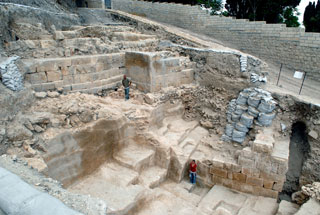
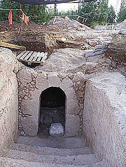
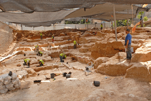
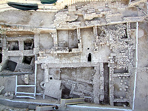
The long search for Herod the Great's tomb ended with the exposure of the remains of his grave, sarcophagus and mausoleum on Mount Herodium's northeastern slope.


Herod was the Roman-appointed king of Judea from 37 to 4 BCE, who was renowned for his many monumental building projects, including the reconstruction of the Temple in Jerusalem, the palace at Masada, as well as the complex at Herodium, 15 kilometers south of Jerusalem. .

Herodium is the most outstanding among King Herod's building projects. This is the only site that carries his name and the site where he chose to be buried and to memorialize himself -- all of this with the integration of a huge, unique palace at the fringe of the desert, said Prof. Netzer. Therefore, he said, the exposure of his tomb becomes the climax of this site's research.

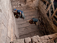
The approach to the burial site - which has been described by the archaeologists involved as one of the most striking finds in Israel in recent years - was via a monumental flight of stairs (6.5 meters wide) leading to the hillside that were especially constructed for the funeral procession.

The excavations on the slope of the mountain, at whose top is the famed structure comprised of a palace, a fortress and a monument, commenced in August 2006. The expedition, on behalf of the Institute of Archaeology of the Hebrew University of Jerusalem, was conducted by Prof. Netzer, together with Yaakov Kalman and Roi Porath and with the participation of local Bedouins.

The location and unique nature of the findings, as well as the historical record, leave no doubt that this was Herod's burial site, said Prof. Netzer.

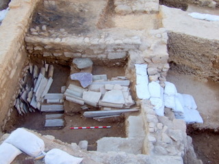
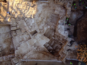
The mausoleum itself was almost totally dismantled in ancient times. In its place remained only part of its well built podium, or base, built of large white ashlars (dressed stone) in a manner and size not previously revealed at Herodium.

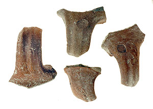
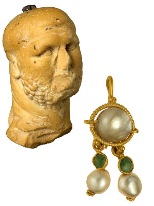
Among the many high quality architectural elements, mostly well decorated, which were spread among the ruins, is a group of decorated urns (made in the form of special jars that were used to store body ashes). Similar ones are to be found on the top of burial monuments in the Nabatean world. The urns had a triangular cover and were decorated on the sides.

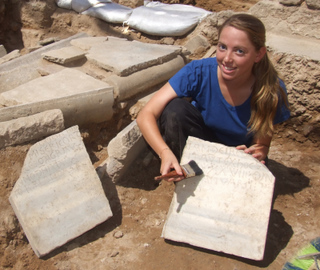
Spread among the ruins are pieces of a large, unique sarcophagus (close to 2.5 meters long), made of a Jerusalemite reddish limestone, which was decorated by rosettes. The sarcophagus had a triangular cover, which was decorated on its sides. This is assumed with certainty to be the sarcophagus of Herod. Only very few similar sarcophagi are known in the country and can be found only in elaborate tombs such as the famous one at the King's Tomb on Selah a-Din Street in East Jerusalem. Although no inscriptions have been found yet at Herodium, neither on the sarcophagus nor in the building remains, these still might be found during the continuation of the dig.

Worthy of note is the fact that the sarcophagus was broken into hundreds of pieces, no doubt deliberately. This activity, including the destruction of the monument, apparently took place in the years 66-72 C.E. during the first Jewish revolt against the Romans, while Jewish rebels took hold of the site, according to Josephus and the archaeological evidence. The rebels were known for their hatred of Herod and all that he stood for, as a "puppet ruler" for the Romans.

The search for Herod's tomb, which actively began 30 years ago, focused until the middle of 2006 at Lower Herodium, in an area which was, no doubt, especially built for the funeral and burial of the king - the "Tomb Estate." In order to reveal there the remains from Herod's days, the expedition was "forced" to first expose a large complex of Byzantine structures (including a church), an effort that demanded many years of digging.

The Tomb Estate included two monumental buildings and a large ritual bath (mikveh) as well as the large route (350 meters long and 30 meters wide) which was prepared for the funeral. When no sign of the burial place itself was found within the Tomb Estate, the expedition started to search for it on the slope of the hill, although there seems to be no doubt that the initial intention of the king was to be buried in the estate and that only in a later stage of his life - apparently when he grew old - did he change his mind and asked to be buried within the artificial cone which gave the hill of Herodium its current volcano-shape.

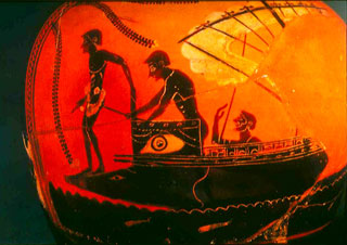
The main historical source of the Second Temple's days, the historian Josephus Flavius, has described the site of Herodium in detail, as well as the funeral in the year 4 BCE, but not the tomb proper. He wrote as follows:

"The king's funeral next occupied his attention. Archelaus, omitting nothing that could contribute to its magnificence, brought forth all the royal ornaments to accompany the procession in honor of the deceased. The bier was of solid gold, studded with precious stones, and had a covering of purple, embroidered with various colors; on this lay the body enveloped in purple robe, a diadem encircling the head and surmounted by a crown of gold, the scepter beside his right hand.

Around the bier were Herod's sons and a large group of his relations; these were followed by the guards, the Thracian contingent, Germans and Gauls, all equipped as for war. The reminder of the troops marched in front, armed and in orderly array, led by their commanders and subordinate officers; behind these came five hundred of Herod's servants and freedmen, carrying spices. The body was thus conveyed for a distance of two hundred furlongs to Herodium, where, in accordance with the directions of the deceased, it was interred. So ended Herod's reign." Jewish Wars, 1,23,9

Prof. Netzer started his archaeological activity at Herodium in 1972, at first on a small scale. The scope of his work widened with the decision to turn Herodium (the mount together with Lower Herodium) into a national park, which was due to occupy 125 acres. (Until that stage only the mount was proclaimed as a national park and was operated by the Nature and Parks Authority.)

The enlargement of the park started in 1980; unfortunately the activity at the site stopped as a result of the first Intifada, but not before the complex of tunnels from the days of Bar-Kokhba, within the mount, were opened to the public. The archaeological excavations at the site, which also stopped in 1987, were renewed 10 years later and continued until 2000, and after a second break, were renewed at the end of 2005.

Underground Cave Dating From The Year 1 A.D.

An artificial underground cave, the largest in Israel, has been exposed in the Jordan Valley in the course of a survey carried out by the University of Haifa's Department of Archaeology. Prof. Adam Zertal, who headed the excavating team, reckons that this cave was originally a large quarry during the Roman and Byzantine era and was a "one of a kind." Various engravings were uncovered in the cave, including cross markings, and it is assumed that this could have been an early monastery.

"It is probably the site of "Galgala" from the historical Madaba Map," Prof. Zertal says.


The enormous and striking cave covers an area of approximately 1 acre: it is some 100 meters long and about 40 meters wide. The cave is located 4 km north of Jericho. The cave, which is the largest excavated by man to be discovered in Israel, was exposed in the course of an archaeological survey that the University of Haifa has been carrying out since 1978.

As with other discoveries in the past, this exposure is shrouded in mystery. "When we arrived at the opening of the cave, two Bedouins approached and told us not to go in as the cave is bewitched and inhabited by wolves and hyenas," Prof. Zertal relates. Upon entering, accompanied by his colleagues, he was surprised to find an impressive architectonic underground structure supported by 22 giant pillars. They discovered 31 cross markings on the pillars, an engraving resembling the zodiac symbol, Roman letters and an etching that looks like the Roman Legion's pennant. The team also discovered recesses in the pillars, which would have been used for oil lamps, and holes to which animals that were hauling quarried stones out of the cave could have been tied.

The cave's ceiling is some 3 meters high, but was originally probably about 4 meters high. According to Prof. Zertal, ceramics that were found and the engravings on the pillars date the cave to around 1-600 AD. "The cave's primary use had been as a quarry, which functioned for about 400-500 years. But other findings definitely indicate that the place was also used for other purposes, such as a monastery and possibly as a hiding place," Prof. Zertal explains.

The main question that arose upon discovering the cave was why a quarry was dug underground in the first place. "All of the quarries that we know are above ground. Digging down under the surface requires extreme efforts in hauling the heavy rocks up to the surface, and in this case the quarrying was immense. The question is, why?"

For a possible answer to this mystery, Prof. Zertal points to the famous Madaba map. This is a Byzantine mosaic map that was found in Jordan and is the most ancient map of the Land of Israel. Jerusalem and the Jordan Valley are depicted with precision on the map, and a site called Galgala is depicted next to a Greek inscription that reads "Dodekaliton", which translates as "Twelve Stones." This place is marked at a distance from Jericho that matches this cave's distance from the city.

According to the map, there is a church next to Dodekaliton; there are two ancient churches located nearby the newly discovered cave. According to Prof. Zertal, until now it has been hypothesized that the meaning of "Twelve Stones" related to the biblical verses that describe the twelve stones that the Children of Israel place in Gilgal. However, it could be that the reference is a description of the quarry that was dug where the Byzantines identified the Gilgal.

"During the Roman era, it was customary to construct temples of stones that were brought from holy places, and which were therefore also more valuable stones. If our assumption is correct, then the Byzantine identification of the place as the biblical Gilgal afforded the site its necessary reverence and that is also why they would have dug an underground quarry there," Prof. Zertal concludes. "But" he adds, "much more research is needed."

Enormous 'Foot-Shaped' Enclosures In Jordan Valley

Foot-shaped" structures have been revealed in the Jordan valley and are among the earliest sites that archeologists believe were built by the ancient people of Israel. The structures are thought to be symbolic of the biblical concept of ownership.


"The 'foot' structures that we found in the Jordan valley are the first sites that the People of Israel built upon entering Canaan and they testify to the biblical concept of ownership of the land with the foot," said archaeologist Prof. Adam Zertal of the University of Haifa, who headed the excavating team that exposed five compounds in the shape of an enormous "foot" -- likely to have been used at that time to mark ownership of territory.

The finding is believed to represent the first time that enclosed sites identified with the biblical sites termed in Hebrew "gilgal", which were used for assemblies, preparation for battle, and rituals, have been revealed in the Jordan valley. The Hebrew word "gilgal" (a camp or stone-structure), is mentioned thirty-nine times in the Bible. The stone enclosures were located in the Jordan valley and the hill country west of it. To this day, no archaeological site has been proposed to be identified with the gilgal.

Between the years 1990 and 2008, during the Manasseh Hill-Country Survey that covers Samaria and the Jordan Valley, five such enclosures were found and excavated, all designed in the shape of a human foot. The site are believed to date back to the outset of the Iron Age I (the 13th-12th centuries BCE). Based on their size and shape, it is clear that they were used for human assembly and not for animals.

Two of the sites (in Bedhat esh-Sha'ab and Yafit 3) were excavated in the years 2002-2005, under the directorship of Dr. Ben-Yosef and the guidance of Adam Zertal. The findings, mostly of clay vessels and animal bones, date their foundation to the end of the 13th century BCE, and one of them endured up to the 9th or 8th century BCE without architectonic adjustment.

In at least two cases, paved circuits, some two meters wide, were found around the structures. These were probably used to encircle the sites in a ceremony. "Ceremonial encirclement of an area in procession is an important element in the ancient Near East," Prof. Zertal says, adding that the origins of the Hebrew term "hag" (festival) in Semitic languages is from the verb "hug", which means "encircle". Thus, this discovery can also shed new light on the religious processions and the meaning of the Hebrew word for festival, "hag".

Prof. Zertal emphasized that the "foot" held much significance as a symbol of ownership of territory, control over an enemy, connection between people and land, and presence of a deity. Some of these concepts are mentioned in ancient Egyptian literature. The Bible also has a wealth of references to the importance of the "foot" as a symbol of ownership, the link between people and their deity, defeating the enemy 'underfoot', and the temple imaged as a foot.

"The discovery of these 'foot' structures opens an entirely new system of linguistic and historical perceptions," Prof. Zertal emphasizes. He explains that the meaning of the biblical Hebrew word for "foot" -- "regel" -- is also a "festival" or "holiday". As such, the source of the Hebrew term "aliya la-regel", literally translated as "ascending to the foot" (and now known in English as a pilgrimage), is attributed to the "foot" sites in the Jordan valley. "Now, following these discoveries, the meanings of the terms become clear. Identifying the 'foot' enclosures as ancient Israeli ceremonial sites leads us to a series of new possibilities to explain the beginnings of Israel, of the People of Israel's festivals and holidays," he stated.

According to Prof. Zertal, the "foot" constructions were used for ceremonial assemblies during Iron Age I (and probably after). When the religious center was moved to Jerusalem and settled there, the command of "aliya la-regel" (pilgrimage) became associated with Jerusalem. The source of the term, however, is in the sites that have now been discovered in the Jordan valley and the Altar on Mt. Ebal. "The biblical text testifies to the antiquity of these compounds in Israel's ceremonials, and the 'foot' structures were built by an organized community that had a central leadership," Prof. Zertal stated.

Assyrian Rulers Hdqrts In Jerusalem Suburb

Dr. Oded Lipschits, from Tel Aviv University's Department of Archaeology, directs Ramat Rachel, an archaeological dig two miles from the Old City of Jerusalem. Until now archaeologists believed the site was a palace of an ancient Judean king, probably King Hezekiah, who built it around 700 BCE.

But evidence points to foreign rule, says Dr. Lipschits, who believes the site was likely an ancient local administrative center -- a branch office -- of Assyrian rulers. "They were wise rulers," he says, "using a good strategy for keeping control, stability and order in the region."

As today's corporations know well, the strategy was all about location. Explains Lipschits, "Between 700 BCE to about 70 CE, Jerusalem was home to various Judean cults and at times a center for religious fanaticism. The Assyrians understood that they could gain better control of their vassal kingdom -- and continue collecting taxes -- by maintaining a safe distance."

Where did they set up their branch offices? In the "suburbs." The Assyrians built their economic hub for the region two miles south of Jerusalem at Ramat Rachel. They created elaborate gardens, stocked their cellars with the wine and olive oil they collected in taxes, and quietly but carefully monitored Jerusalem.

"You can see Jerusalem from Ramat Rachel, but when you're inside Jerusalem's City of David, you can't see Ramat Rachel at all," says Lipschits. "The Assyrians kept a watchful eye, but didn't let the locals feel a dominant foreign presence.

"It was smart for the Assyrian managers to take a few steps back, and not appear to be interfering with the city's religious center and local culture. Businesses today could be advised to adopt similar strategies with their branch offices in foreign locations," he surmises.

Tel Megiddo: Armageddon

Tel Aviv University archaeologists are studying Tel Megiddo, the New Testament location of "Armageddon," and unearthing truths about King Solomon.


Some come to dig the archeological site at Tel Megiddo because they are enchanted by ancient stories of King Solomon. Others come because they believe in a New Testament prophecy that the mound of dirt will be the location of a future Judgment Day apocalyptic battle. Hence the second, rather more chilling name for the site: "Armageddon."

Tel Megiddo has been the subject of a number of decisive battles in ancient times (among the Egyptian, Hebrew and Assyrian peoples) and today it holds a venerated place in archaeology, explains site co-director and world-renowned archeologist Prof. Israel Finkelstein.

Says Prof. Finkelstein, from the Department of Archaeology and Ancient Near Eastern Cultures at Tel Aviv University, "Megiddo is one of the most interesting sites in the world for the excavation of biblical remains. Now volunteers and students from around the world can participate in the dig which lets them uncover 3,000 years worth of history -- from the late 4th millennium B.C.E. to the middle of the first millennium C.E."

Prof. Finkelstein, who belongs to the Sonia and Marco Nadler Institute of Archaeology at Tel Aviv University, has been co-directing the site with Prof. David Ussishkin, also of Tel Aviv University, since 1994.

Likened to a "lightening rod" by the journal Science (2007), Prof. Finkelstein is famous for his unconventional way of interpreting biblical history: he puts emphasis on the days of the biblical authors in the 7th century B.C.E. and theorizes that ancient rulers such as David and Solomon, who lived centuries earlier, were "tribal chieftains ruling from a small hill town, with a modest palace and royal shrine."

Yet, "new archaeological discoveries should not erode one's sense of tradition and identity," he states.

Prof. Ze'ev Herzog, who heads the archaeology institute at Tel Aviv University, says, "There has been an important revolution in biblical history in the last decades. We are now uncovering the difference between myth and history, and between reality and ideology of the ancient authors. This is the role of our generation of archaeologists -- to unearth the real historical reality to find out why and how the biblical records were written."

The archeologists aren't the only ones looking for answers. More than one hundred volunteers come from all corners of the world to dig Megiddo alongside Prof. Finkelstein every year. They are teachers, journalists, actors, construction workers, professors and housewives, as well as archaeology, history and divinity students who dig for credit.

Saturday, December 5, 2009

Archaeological Evidence Of Exodus in Egypt!

*
An exciting new analysis from one of Egypt's most prominent archaeologists about the Aper-el or Aper-al tomb in the Saqqara region:


The Whisper of Tombs

29/10/2009
By Dr. Zahi Hawass

Cairo, Asharq Al-Awsat- In my opinion, the Israelite Exodus from Egypt will remain a point of controversy amongst scientists and researchers until the Day of Judgment or until new archaeological evidence is unearthed that is able to settle this issue. However in light of the information currently available to historians and archaeologists, we can do no more than practice moderation and caution.

There have been whispers in the archaeological community following the discovery of the Aper-al tomb in the Saqqara region in the area known as Abwab al-Qotat [Doors of the Cats] by French archaeologist Alain Zivie. Abwab al-Qotat was given its name following the discovery of thousands of mummified cats interred in the tomb...

The discovery of this tomb which took place almost 20 years ago remains an important archaeological event. The reason for this is that the person buried in the tomb was known as "Aper-al" and this is an Egyptianized form of a Hebrew name. Aper-al was the vizier for King Amenhotep III, and later for his son King Akhenaten. Pharaoh Akhenaten was the first ruler to institute monotheism represented by the worship of the sun which he called Aten.

Excavations of this tomb continued for almost 10 years, beginning in 1980 and ending in late 1989. Amongst the artefacts discovered here were several portraits entitled "spiritual father of Aten" as well as "the Priest" and "the first servant of Aten." This means that Aper-al served as the chief priest of Aten in the Memphis region during the reign of King Akhenaten.

Of course the effects of the news of the discovery of a Hebrew tomb has raised many questions and controversies amongst archaeologists with regards to whether or not a temple for Aten existed in Memphis or not. The portraits found in the Aper-al tomb indicate that such a temple did in fact exist in Memphis, and this is contrary to the tradition accepted by archaeologists which is that monotheism [Atenism] did not exist beyond the city of Tell el-Amrana in central Egypt. Tel-Amrana was the city founded by Akhenaten for his family. Akhenaten swore never to depart the city so long as he lived, and he named it Akhen-Aten meaning the city faithful and loyal to Aten.

In addition to this, there has been prolonged controversy between Torah scholars and archaeologists over the credibility of Aper-al in fact being a Hebrew name. This creates the impression that Hebrews were present in Egypt during the eighteenth dynasty, and that some Egyptianized Hebrews held senior state positions. It is important to emphasize that all the artefacts discovered in the Aper-al tomb, such as the sarcophagus, the mummies, as well as the carvings on the walls of the tomb, are consistent with the Egyptian style of the time. Even Aper-al’s portrait, his cloths, and his jewellery, are purely ancient Egyptian. This is the truth, the whole truth, and nothing but the truth.


A video describing the findings:


Portrait of Aper-el and his daughter


And another dazzling report:

The remains of the Vizier, his wife and their son were found in beautiful coffins, along with canopic jars of alabaster, objects of daily and religious use, and many jewels. The gold was transferred to the Cairo Museum and is on exhibit there. The beautiful rings and bracelets can be compared only with those found at Thebes at the beginning of this century.

Dr. Zivie's report, referring to the funerary chamber as the 'chapel', stated that:

"...until the end of 1993, only a small part of the chapel itself, near the entrance, was known. A late masonry, very compact and thick, was present almost everywhere at the first level of the tomb, preventing investigation. This masonry is no only present in Aper-El's tomb, with its representations of the Vizier. Three cult niches were revealed when we removed the masonry and gebel (dry stones) which had blocked the entire chapel..

The decoration on the main, central, niche remained in a very good state of preservation. On the sides are paintings of the Vizier, each with his complete name, Aper-EI, receiving offerings of flowers or purification from two sons previously unknown to us. Their names and titles are present: one, Seny, was a high official; the other, Hatiay, was a priest. The representations are important because they illustrate the art of the time of Akhenaton (the Amarna Period) and its aftermath not at Amarna or at Thebes, but rather at Memphis, which remained the main city of the country.

But also in some neighboring tombs. This masonry can almost certainly be dated to the beginning of the Ptolemaic (Greek) Period. The site would have been consolidated then for re-use in cat burials at the sanctuary of Bastet above the cliff.

It was necessary to remove the blocking (late masonry) in order to explore the chapel completely... a technical task, not a work of excavation. We undertook it with the agreement of the Egyptian Antiquities Organization. The operation provided the Mission with a chance discovery: the larger part of the chapel of the tomb had been hidden by the masonry. The decoration had been very well preserved behind the stones and mortar.

The work took several months, but the chapel is now completely cleared... Now we have a complete picture of the first level of the tomb. The result is impressive. There are three square pillars, one completely unknown before, on the inner faces of which one can still discern representations of the Vizier and of his son. The fourth pillar is no longer present. A splendid ceiling, beautifully decorated in brilliant colors, is also almost completely preserved.

The Southern Wall of Jerusalem: Second Temple era

An exciting discovery in Jerusalem constituting extraordinary remains of the wall of the city from the time of the Second Temple (second century BCE-70 CE) that was built by the Hasmonean kings and was destroyed during the Great Revolt, and also the remains of a city wall from the Byzantine period (324-640 CE) which was built on top of it, were uncovered in an extensive excavation that is currently underway on Mount Zion. The lines of these fortifications delineated Jerusalem from the south in periods when the ancient city had reached its largest size.


The lines of the wall that delineate Mount Zion from the west and the south were first discovered and excavated at the end of the nineteenth century (1894-1897) by the Palestine Exploration Fund, under the direction of the archaeologist Frederick Jones Bliss and his architect assistant, Archibald Dickie. The work methods they employed involved the excavation of shafts that were linked by subterranean tunnels which ran along the outer face of the city walls.

Over the years their shafts and tunnels have filled up with soil and a year and a half ago when archaeologists were asked to determine the location of the areas that were excavated one hundred years ago they were unsuccessful in doing so. By cross-referencing the plans of the old excavation with updated maps of the area from today archaeologist Yehiel Zelinger was able to locate the tunnel which the British expedition had dug. There remained in it “souvenirs” that were left behind by the early excavators in the form of one of the laborer’s shoes, the top of a gas light which was used to illuminate the tunnels, as well as fragments of beer and wine bottles from 120 years ago.

According to Yehiel Zelinger, excavation director on behalf of the Israel Antiquities Authority, “Having located the two city walls on Mount Zion corroborates our theory regarding the expansion of the city toward the south during these two periods, when Jerusalem reached its largest size. In the Second Temple period the city, with the temple at its center, was a focal point for Jewish pilgrimage from all over the ancient world and in the Byzantine period it attracted Christian pilgrims who came in the footsteps of the story of the life and death of their messiah. The exposure of the Hasmonean city wall and the line of fortifications from the Byzantine period, which is dated 400 years later and is right on top of the former, prove that this is the most advantageous topographic location for the defense of the city. The artifacts indicate that in spite of the fact that the builders of the Byzantine wall were unaware of the existence of the wall from the time of the Second Temple they constructed their wall precisely along the same route”.

Zelinger adds, “The fact that after 2,100 years the remains of the first city wall were preserved to a height of three meters is amazing. This is one of the most beautiful and complete sections of construction in the Hasmonean building style to be found in Jerusalem”.

Thursday, November 26, 2009

Greetings from Ahimelekh and Yehokhil,

from Netofa in Judah


Royal seal impressions, Image: Mariana Saltzberger , Israel Antiquities Authority

Royal seal impressions were discovered in excavations of the Israel Antiquities Authority at Umm Tuba, in the southern hills of Jerusalem.

A large building that dates to the time of the First and Second Temples, in which there was an amazing wealth of inscriptions, was discovered in a salvage excavation conducted by Zubair Adawi, on behalf of the Israel Antiquities Authority, in the village of Umm Tuba in southern Jerusalem (between Zur Bahar and the Har Homa quarter), prior to construction work by a private contractor.

Considering the limited area of the excavation and the rural nature of the structure that was revealed, the excavators were surprised to discover in it so many royal seal impressions that date to the reign of Hezekiah, King of Judah (end of the eighth century BCE). Four “LMLK” type impressions were discovered on handles of large jars that were used to store wine and oil in royal administrative centers. These were found together with the seal impressions of two high ranking officials named Ahimelekh ben Amadyahu and Yehokhil ben Shahar, who served in the kingdom’s government. The Yehokhil seal was stamped on one of the LMLK impressions before the jar was fired in a kiln and this is a very rare instance in which two such impressions appear together on a single handle.


Royal seal impressions, Image: Mariana Saltzberger , Israel Antiquities Authority

Another Hebrew inscription, 600 years later than the seal impressions of the Kingdom of Judah, was discovered on a fragment of a jar neck that dates to the Hasmonean period. An alphabetic sequence was engraved with a thin iron stylus below the vessel’s rim in Hebrew script that is characteristic of the beginning of the Hasmonean period (end of the second century BCE). The letters hay to yod and a small part of the letter kaf were preserved on the sherd. Similar inscriptions bearing alphabetic sequences were discovered in the past, usually on ostraca (inscriptions written in ink on pottery sherds) or engraved on ossuaries (stone receptacles in which human bones were buried). The alphabetic inscription that was discovered in this instance is unique and the significance of it requires further study: was this a “writing exercise” done by an apprentice scribe or should we ascribe it some magical importance?

The remains of the large building included several rooms arranged around a courtyard. Pits, agricultural installations and subterranean silos were hewn inside the courtyard. A potter’s kiln, a large columbarium cave in which there is a rock-hewn hiding refuge, pottery vessels, etc were also discovered inside the built complex. The pottery vessels that were recovered from the ruins of the building indicate it first dates to the end of the Iron Age (the First Temple period) in the eighth century BCE. Following its destruction, along with Jerusalem and all of Judah during the Babylonian conquest, Jews reoccupied it in the Hasmonean period (second century BCE) and it existed for another two hundred years until the destruction of the Second Temple. During the Byzantine period the place was reinhabited as part of the extensive rural settlement of monasteries and farmsteads in the region between Jerusalem and Bethlehem.

Some three years ago the impressive remains of a monastery from this period were excavated that together with the remains of the current excavation confirm the identification of the place as “Metofa”, which is mentioned in the writings of the church fathers in the Byzantine period. The name of the Arab village, “Umm Tuba” is therefore a derivation of Byzantine “Metofa”, which is Biblical “Netofa” and is mentioned as the place from which two of David’s heroes originated (2 Samuel 23:28-29).

Saturday, November 21, 2009

Second Temple Era: Magnificent Arch, Ritual Baths

The remains of a Jewish settlement that dates from the latter part of the Second Temple period (the first century BCE)have been discovered.

A magnificent arch built of large well-dressed stones was uncovered in the excavations. The arch was attached to the side of a ritual bath (miqve) that was discovered there and led to a subterranean chamber. Installations were also discovered that are ascribed to a Jewish settlement that existed there at the time of the Second Temple period, among them a number of ritual baths that were used by the residents in maintaining the halachic practices of purity.


Blocked openings were revealed inside the installations at the site. These raise the possibility that behind them are tunnels similar to the hiding refuges that were discovered in this region in the past. The latter were also dug inside of installations during the time of the Bar Kokhba uprising (132 CE) and were used by the rebels in concealing themselves from the Romans. The openings that were found in this excavation were probably used for a similar purpose, but have not yet been uncovered.

The excavation director has noted that in addition to the discovery of the finds, this excavation clearly shows that the area of the Jewish settlement that was excavated in this region in the past extends across a larger area than was previously believed.

During the excavation a very large amount of pottery sherds was found that date to the Roman, Byzantine and later periods. The vessels include different kinds of oil lamps, jars, cooking pots, amphorae, and juglets. Among the other small finds that were recovered in the excavation are numerous glass vessels, some of which are kinds that were previously unknown from this period, various coins and an object that is believed to be a part of a pendant.

Crusader Era Marble Hoard in Akko

In an excavation that was recently conducted c. 100 meters north of the Old City wall of Akko, a unique find was discovered from the Crusader period (the thirteenth century CE) – a hoard of 350 marble items that were collected from buildings that had been destroyed.


The hoard was found within the framework of an archaeological excavation conducted by the Israel Antiquities Authority before the AkkoMunicipality began building a new structure to house classrooms in the Hilmi Shafi Educational Campus.


According to Dr. Edna Stern, excavation director on behalf of the Israel Antiquities Authority, “We have here a unique find, the likes of which have never been discovered in the Kingdom of Jerusalem in the Crusader period (the capital of which was Akko). During the archaeological excavations we came upon a cellar that was sealed by collapse comprised of building stones and charred beams. Beneath the cellar floor a hoard of c. 350 marble items and colored stones was discovered, including two broken marble tombstones with Latin inscriptions (one belonging to a person by the name of Maratinus), flat marble slabs and marble tiles of various sizes and colors, etc. Some extraordinary items were also found, among them a large stone cross and a large fragment of porphyry (a rare precious purple stone, which has been the color of royalty from Roman times). The quality of the marble is excellent and it was undoubtedly imported from abroad.”


Dr. Stern added, “Everyone knows that Crusader Akko was an important center for international trade and the marble hoard reflects the magnificent buildings that were erected here but have not survived, as well as also the commerce and the wealth of its residents. Just as there is a trend today to incorporate wooden doors from India or roof tiles from old buildings in Italy in modern villas, at that time they used to integrate ancient architectural items from the Roman and Byzantine periods in their construction. And just like today, people at that time also yearned for the classic and the exotic. We know from written sources that they bought and sold such stones, which were exceptionally valuable, to be reused in buildings. We can assume that the owner of the hoard, whether he was a merchant or he collected the stones for his own construction, was aware of impending danger and therefore buried the valuable stones until such time as the tension abated.

However, the cache of stones was not sold in the end. According to Stern, “We can reasonably assume that the collapse that was found above the hoard is evidence of the building’s destruction in 1291 CE, when Crusader Akko was conquered by the Mamluks and was completely devastated”.

The marble hoard was removed from the field and transferred to the Israel Antiquities Authority for further study.

Tuesday, November 17, 2009

Ancient Weapons Dug Up in England

Staff at the University of Leicester Archaeological Services (ULAS) have been excited by the results from a recently excavated major Prehistoric site at Asfordby, near Melton Mowbray, Leicestershire. The Mesolithic site may date from as early as 9000 BC, by which time hunter-gatherers had reoccupied the region after the last ice age. These hunters crossed the land bridge from the continental mainland -- 'Britain' was only to become an island several thousand years later.

The site was excavated during 2009 by ULAS in advance of a residential development for Jelson Homes Ltd. Initial trenching work identified several worked flint blades of characteristic Mesolithic type, and clearly in an unworn and undisturbed state. Further work confirmed that these rare flint finds were preserved in a Mesolithic soil, buried by a much later ploughsoil. Because this early soil had survived intact, it was thought possible that original features such as hearths and structures might still remain, and activities linked to the flint scatter could also be found.


Excavation targeted an area just ten metres square, where the limits of the flint scatter had been identified from test results. Within this small area, a charcoal rich former hearth was found, and also several postholes and arcs of stones that may show the position of tent-like structures. Burnt animal bone and further charcoal chips were also found indicating cooking activities. The site is probably located where it is at least partly because the local soils have natural flint chunks or 'nodules' that could have been used for flintworking. Also, the site would have been a shallow valley in Mesolithic times, and sheltered from the elements.

As important as this evidence was however, the worked flint from site was what really made the excavations significant. Over 5000 worked flints came from this small area, including flint cores used for tool creation, blades, flakes and 'debitage' (small chips from tool-working), and scrapers, piercers and microlith tools with the latter being used in composite arrowheads. The Mesolithic people were occupying this site making and repairing broken flint weapons and tools on a large scale. Some of the microlith projectile points have impact fractures indicating that they had been used in arrowheads which had then been collected and reused. These tasks would have been carried out as part of a range of activities associated with their hunting expeditions.

Further work on the finds from this regionally unique site is still to be carried out at the University of Leicester. The finds -- worked flint, animal bone and charcoal, will allow archaeologists to identify the flintworking processes and other tasks carried out, the different animals that were hunted, and the environment at the time of the Mesolithic hunters.

Monday, November 9, 2009

Minoan-style painting in Canaanite palace

Remains of Minoan-style painting discovered during excavations of Canaanite palace

Tel Kabri is the only site in Israel where wall paintings similar in style to those found in the Aegean 3,600 years ago have been found; researchers say this was a conscious decision made by the city rulers to lean toward Mediterranean culture.

The remains of a Minoan-style wall painting, recognizable by a blue background, the first of its kind to be found in Israel, was discovered in the course of the recent excavation season at Tel Kabri. This fresco joins others of Aegean style that have been uncovered during earlier seasons at the Canaanite palace in Kabri. "It was, without doubt, a conscious decision made by the city's rulers who wished to associate with Mediterranean culture and not adopt Syrian and Mesopotamian styles of art like other cities in Canaan did. The Canaanites were living in the Levant and wanted to feel European," explains Dr. Assaf Yasur-Landau of the University of Haifa, who directed the excavations.


Pieces of Minoan-style blue pottery found in the excavations.

The remains of a Canaanite city from the Middle Bronze Age (2000-1550 B.C.) have been exposed at Tel Kabri, next to Kibbutz Kabri near Nahariya. A palace for the city's rulers stands in the center of the city, which was the most important of the cities in the Western Galilee during that period. Excavations began at Tel Kabri in 1986, conducted by the late Prof. Aharon Kempinski, and were halted in 1993. Over the past years, excavations have been renewed by teams directed by Dr. Yasur-Landau of the Leon Recanati Institute for Maritime Studies at the University of Haifa and Prof. Eric Cline of The George Washington University. Tel Kabri is unique in that after the city was deserted, no other city was built over its remains. Therefore, this is the only Canaanite city that can be excavated in its entirety. The palace too, which has been measured with geophysical tools at 1 to 1.5 acres, is the only such palace of this period that can be excavated fully. "The city's preservation enables us to get a complete picture of political and social life in the Canaanite period. We can reveal whether or not it had a central government, whether taxes were levied, what sort of agriculture there was and how politics were conducted at the time," Dr. Yasur-Landau explains.


The recent excavation season has enabled researchers to conclude what the rulers' cultural preferences were. While excavations at Tel Hazor in the northern Galilee, the largest Canaanite city of that period, revealed numerous remains of sculpture works of Syrian and Mesopotamian style, no such evidence of this style of artwork were discovered at Tel Kabri. Until now the remains of a fresco in a style that had been common on the island of Santorini (Thera), discovered during previous seasons at the Tel Kabri site, might have been considered a solitary occurrence. However, the remains of additional works reinforce the conjecture that this was a city that not only had trade relations with Mediterranean kingdoms, but also preferred to be culturally associated with them. "Unlike Hazor, which held trading and cultural ties with Syria and Mesopotamia, the rulers of the city at Tel Kabri consciously chose the Mediterranean alternative, relating to Aegean cultures, which doubtlessly seemed more exotic to the local inhabitants," Dr. Yasur-Landau explains.


Ancient cup uncovered in the palace corridor.


Additional findings during the past season illuminate other angles of day-to-day life in the Canaanite city. The researchers discovered that the rulers confiscated privately owned lands in order to build both the palace and a ceremonial path encircling the palace. The researchers also began digging a corridor that had been discovered last year and found tens of pottery vessels there, such as storage jars, shallow bowls, cups, and jugs. The corridor, which probably served as a storage area, was blocked off by the ancient inhabitants, and therefore remnants of the substances held in these pottery vessels still remains, as did many animal bones. "We sent the bones and substance remains to be examined, so we should soon be able to know more about the standard diet of that time and in this particular area," Dr. Yasur-Landau added.

Saturday, October 31, 2009

Inscription from the Period of the Kings of Judah

A fragment of a limestone plaque bearing several letters of ancient Hebrew script was discovered while sifting soil that was excavated in the vicinity of the Gihon Spring, within the precincts of the “Walls around Jerusalem National Park”.


The stone fragment dates to the eighth century BCE and this is based on the numerous pottery sherds that were discovered together with it, as well as the shape of the Hebrew letters that are engraved in the inscription.

The plaque is broken on all sides. All that remains of the inscription are two lines of writing: In the upper line the last part of a given name is preserved: ...]קיה, or as it is transliterated into English …]kiah. Unfortunately the remains of another letter before the kof cannot be discerned. If the letter preceding the kof was a zayin, we could complete the name to read חזקיה, or Hezekiah in English, and perhaps ascribe historical importance to the inscription. On the other hand, there are other first names that were used in Judah and Jerusalem at that time that could be mentioned here such as Hilkia, Amekiya, etc.

In the second line are the remains of two words. Here too, is a suffix of a word: ...]×›×”, or as it is transliterated into English …]ka. Here we have several possibilities for completing the word such as: בְּרָ×›ָ×”, or birqa, that is, a greeting expressing best wishes (a possible ending for some sort of commemorative inscription). Another possibility is the word בְּרֵ×›ָ×”, or brecha, meaning water reservoir. The reconstruction of this word is possible based on the fact that Brechat HaShiloah, or the Shiloah Pool in English, is located nearby, and also based on the fact that a pool is mentioned in the famous Shiloah inscription that was discovered close by.

In any event the fact that we are dealing with a stone plaque indicates that this is a commemorative inscription that may have been meant to celebrate some sort of building project.

All that remains is to wait and hope that in time other fragments of the inscription will be found.

Wednesday, October 28, 2009

Quarry from the End of the Second Temple Period

.

An ancient quarry, c. 1 dunam in area and dating to the end of the Second Temple period (c. 2,030 years old), was uncovered in excavations being conducted on Shmuel HaNavi Street in Jerusalem, under the direction of Dr. Ofer Sion and Yehuda Rapuano of the Israel Antiquities Authority, prior to the construction of residential buildings.


Dr. Ofer Sion, the excavation director on behalf of the Israel Antiquities Authority, believes, “The immense size of the stones (maximum dimensions: length 3 m, width 2 m, height 2 m) indicates it was highly likely that the large stones that were quarried at the site were destined for use in the construction of Herod’s magnificent projects in Jerusalem, including the Temple walls. It seems that a vast number of workers labored in the quarry where various size stones were produced: first they quarried small stones and when the bedrock surface was made level they hewed the large stones. The stones were quarried by creating wide detachment channels that were marked by means of a chisel which weighed c. 2.5 kilograms. After the channels were formed the stones were severed from the bedrock using hammers and chisels”.

“We know from historical sources that in order to build the Temple and other projects which Herod constructed, such as his palace, hundreds of thousands of various size stones were required – most of them weighing between two and five tons each”, said Dr. Sion. “The dimensions of the stones that were produced in the quarry that was revealed are suitable for the Temple walls. The large section that was exposed is actually a small part of an enormous series of quarries that was spread across the entire slope – from the Musrara Quarter to the Sanhedria Quarter. The massive quarrying effort, on the order of hundreds of thousands of stones, lowered the topography of Jerusalem in the vicinity of the Old City. Today, with the exposure of this quarry, the intensity of the building projects as described in the historical sources can be proven: Flavius Josephus wrote that before Herod built the Temple he prepared the infrastructure for it: the quarrying of the Temple’s stones lasted eight whole years. The Temple itself was built in a relatively short period of time of two years. With the exposure of the quarries in Sanhedria and Ramat Shlomo, it is clear that Herod began quarrying closest to the Temple and worked away from it: first he exploited the stone on the nearby ridges and subsequently he moved on to quarry in more distant regions”.


According to Dr. Sion, “In those days the world of hi-tech focused on quarrying, removing and transporting stones. Historical sources record that Herod trained more than 10,000 people to be involved in this work: they prepared suitable transportation routes and then moved the huge stones in a variety of ways – on rolling wooden fixtures that were drawn by camels, in pieces on carriages, etc.

Among the artifacts that were discovered in the excavation on Shmuel HaNaiv Street were metal plates (referred to in the Talmud as ‘cheeks’) that were used as fulcrums to severe the stones from the bedrock, and coins and pottery sherds that date to the end of the Second Temple period (the first century BCE).

2,000 Year Old Miqve in Jerusalem

-

A large and impressive ritual bath (miqve) from the end of the Second Temple period was recently uncovered in archaeological excavations the Israel Antiquities Authority is carrying out in the Western Wall tunnels, in cooperation with the Western Wall Heritage Foundation.


The miqve was discovered inside the western hall of a splendid structure that is located just c. 20 meters from the Western Wall. Parts of the building were discovered in the past and the Israel Antiquities Authority is currently exposing another one of the three halls inside it. It is one of the most magnificent structures from the Second Temple period ever to be uncovered.

The edifice is built of very delicately dressed ashlar stones and the architectural decoration in it is of the highest quality. From an architectural and artistic standpoint there are similarities between this structure and the three magnificent compounds that King Herod built on the Temple Mount, in the Cave of the Patriarchs and at Allonei Mamre, and from which we can conclude the great significance that this building had in the Second Temple period.

In his book The War of the Jews, Josephus Flavius writes there was a government administrative center that was situated at the foot of the Temple. Among the buildings he points out in this region were the council house and the “Xistus”- the ashlar bureau. According to the Talmud it was in this bureau that the Sanhedrin – the Jewish high court at the time of the Second Temple – would convene. It may be that the superb structure the Israel Antiquities Authority is presently uncovering belonged to one of these two buildings.

According to archaeologist Alexander Onn, director of the excavation on behalf of the Israel Antiquities Authority, “It is interesting to see that in the middle of the first century CE they began making changes in this magnificent structure – at that time it was no longer used as a government administrative building and a large miqve was installed inside its western hall where there were c. 11 steps that descend to the immersion pool. It seems that the city of Jerusalem grew in this period and it became necessary to provide for the increased ritual bathing needs of the pilgrims who came to the Temple in large numbers, especially during the three pilgrimage festivals (Shlosha Regalim). Immersing oneself in the miqve and maintaining ritual purity were an inseparable part of the Jewish way of life in this period, and miqve’ot were absolutely essential, especially in the region of the Temple.”

The Western Wall Heritage Foundation acts to uncover the Jewish people’s past at the Western Wall, and the miqve is further evidence of the deep ties the Jewish people have with Jerusalem and the Temple.

Rabbi Shmuel Rabinowitz, the rabbi in charge of the Western Wall and the holy places, pointed out the cooperation between the Western Wall Heritage Foundation and the Israel Antiquities Authority which have joined together in order to discover the rich history of Jerusalem there, while strictly ensuring that no excavations approach the Temple Mount compound, contact with which is forbidden by Halachic law.

Saturday, October 24, 2009

"The Heliodoros stele" and the Maccabean Revolt

"The Heliodoros stele"- consisting of 28 lines inscribed on limestone is considered one of the most important ancient inscriptions found in Israel. Recently, three smaller fragments of a Greek inscription were found at an Israel Antiquities Authority excavation at Maresha.

Dr. Dov Gera determined that the fragments were actually the lower portion of "The Heliodoros stele". This discovery confirmed the assumption that the stele originally stood in one of the temples in Maresha- Beit Guvrin National Park today. It now can be determined that this royal stele originated in the city of Maresha.

The stele adds important archaeological evidence and historical context for understanding the period of time leading up to the Maccabean Revolt, an event celebrated each year on the holiday of Hanukah.


The Heliodoros Stele - with all of its pieces restored - photograph Peter Lenny, Israel Museum Jerusalem

This royal stone stele bears a proclamation by the Seleucid king, Seleucus IV (brother of Antiochus IV), and dates to 178 BCE. The contents of the stele shed light on the Seleucid government's involvement in local temples, mentioning an individual named Olympiodoros, the appointed "overseer" of the temples in Coele Syria – Phoenicia, including Judea. The order of the king was sent to Heliodorus, who was probably the same person mentioned in II Maccabees 3.

According to the story in Maccabees, Heliodorus, as the representative of King Seleucus IV, tried to steal the wealth from the Temple in Jerusalem but instead was severely beaten as a result of divine intervention. Three years later Seleucus IV was assassinated and was succeeded by his brother Antiochus IV, who was the ruler who according to II Maccabees eventually issued an edict of persecution against the Jewish people and desecrated the Temple in Jerusalem leading to the Maccabean Revolt.

Royal seal impressions discovered

Royal seal impressions were discovered in excavations of the Israel Antiquities Authority at Umm Tuba, in the southern hills of Jerusalem.

Considering the limited area of the excavation and the rural nature of the structure that was revealed, the excavators were surprised to discover in it so many royal seal impressions that date to the reign of Hezekiah, King of Judah (end of the eighth century BCE). Four “LMLK” type impressions were discovered on handles of large jars that were used to store wine and oil in royal administrative centers. These were found together with the seal impressions of two high ranking officials named Ahimelekh ben Amadyahu and Yehokhil ben Shahar, who served in the kingdom’s government. The Yehokhil seal was stamped on one of the LMLK impressions before the jar was fired in a kiln and this is a very rare instance in which two such impressions appear together on a single handle.


Another Hebrew inscription, 600 years later than the seal impressions of the Kingdom of Judah, was discovered on a fragment of a jar neck that dates to the Hasmonean period. An alphabetic sequence was engraved with a thin iron stylus below the vessel’s rim in Hebrew script that is characteristic of the beginning of the Hasmonean period (end of the second century BCE). The letters hay to yod and a small part of the letter kaf were preserved on the sherd. Similar inscriptions bearing alphabetic sequences were discovered in the past, usually on ostraca (inscriptions written in ink on pottery sherds) or engraved on ossuaries (stone receptacles in which human bones were buried). The alphabetic inscription that was discovered in this instance is unique and the significance of it requires further study: was this a “writing exercise” done by an apprentice scribe or should we ascribe it some magical importance?


The remains of the large building included several rooms arranged around a courtyard. Pits, agricultural installations and subterranean silos were hewn inside the courtyard. A potter’s kiln, a large columbarium cave in which there is a rock-hewn hiding refuge, pottery vessels, etc were also discovered inside the built complex. The pottery vessels that were recovered from the ruins of the building indicate it first dates to the end of the Iron Age (the First Temple period) in the eighth century BCE. Following its destruction, along with Jerusalem and all of Judah during the Babylonian conquest, Jews reoccupied it in the Hasmonean period (second century BCE) and it existed for another two hundred years until the destruction of the Second Temple. During the Byzantine period the place was reinhabited as part of the extensive rural settlement of monasteries and farmsteads in the region between Jerusalem and Bethlehem.

Some three years ago the impressive remains of a monastery from this period were excavated that together with the remains of the current excavation confirm the identification of the place as “Metofa”, which is mentioned in the writings of the church fathers in the Byzantine period. The name of the Arab village, “Umm Tuba” is therefore a derivation of Byzantine “Metofa”, which is Biblical “Netofa” and is mentioned as the place from which two of David’s heroes originated (2 Samuel 23:28-29).

City of David: Magnificent Roman Building

A spacious edifice from the Roman period (third century CE) – apparently a mansion that belonged to a wealthy individual – was recently exposed in the excavations the Israel Antiquities Authority is carrying out in the 'Givati Car Park' at the City of David, in the Walls Around Jerusalem National Park.


According to Dr. Doron Ben-Ami, the excavation director on behalf of the IAA, together with Yana Tchekhanovets, “Although we do not have the complete dimensions of the structure, we can cautiously estimate that the building covered an area of approximately 1,000 square meters. In the center of it was a large open courtyard surrounded by columns. Galleries were spread out between the rows of columns and the rooms that flanked the courtyard. The wings of the building rose to a height of two stories and were covered with tile roofs”.

A large quantity of fresco fragments was discovered in the collapsed ruins from which the excavators deduced that some of the walls of the rooms were treated with plaster and decorated with colorful paintings. The painted designs that adorned the plastered walls consisted mostly of geometric and floral motifs. Its architectural richness, plan and particularly the artifacts that were discovered among its ruins bear witness to the unequivocal Roman character of the building. The most outstanding of these finds are a marble figurine in the image of a boxer and a gold earring inlaid with precious stones.


The building, which was constructed during the third century CE, was shaken by a tremor in the fourth century, the results of which are clearly apparently in the excavation area:the walls of the rooms caved-in and their stone collapse, which was piled high, covered the walls of the bottom floor, some of which still stand to a considerable height. Architectural elements such as columns and capitals, as well as mosaics and the large amount of fresco fragments that were used in the rooms of the second story were discovered inside the collapsed ruins. The coins that were discovered among the collapse and on the floors indicated the building’s ruins should be dated to circa 360 CE. It seems that what we have here is archaeological evidence of the results of the earthquake that struck our region in 363 CE.

Dr. Ben-Ami adds, “We know of no other buildings from the Roman period that were discovered in Israel which have a similar plan to that of the building from the City of David. The closest contemporary parallels to this structure are located in sites of the second-fourth century CE that were excavated in Syria. Edifices such as these are “urban mansions” from the Roman period that were discovered in Antioch, Apamea and Palmyra. If this parallel is correct, then in spite of its size and opulence, it seems that this building was used originally as a private residence”.

The exposure of the Roman building in the City of David is a significant contribution to our understanding of the extent of the construction in the Roman city in the third-fourth centuries CE. It constitutes extremely important archaeological evidence regarding the growth of the settlement at the end of the Roman period into the southern precincts of the city, and it shows that the prevailing supposition among scholars according to which the City of David hill remained outside the area of Roman settlement at the time of the Aelia Capitolina is no longer valid.

The Lod Mosaic And Its Builders


The 1,700 year old mosaic, which is one of the largest and most magnificent ever seen in Israel, was exposed in the city of Lod in 1996. It is a real archaeological gem that is extraordinarily well-preserved. It is c. 180 sq m in size. It is composed of colorful carpets that depict in great detail mammals, birds, fish, floral species, and sailing and merchant vessels that were in use at the time. It is believed the mosaic floor was part of a villa that belonged to a wealthy man in the Roman period.

Recently the conservators were surprised to discover that the builders of the beautiful mosaic left their personal mark there: while working on the plaster bedding which is done before attaching the mosaic, the artisans trod on it wearing sandals and in their bare feet.


According to Jacques Neguer, head of the IAA Art Conservation Branch, “When removing a section of mosaic it is customary to clean its bedding, and that way study the material from which it is made and the construction stages. We look for drawings and sketches that the artists made in the plaster and marked where each of the tesserae will be placed. This is also what happened with the Lod mosaic: beneath a piece on which vine leaves are depicted, we discovered that the mosaic’s builders incised lines that indicate where the tesserae should be set, and afterwards, while cleaning the layer, we found the imprints of feet and sandals: sizes 34, 37, 42 and 44. At least one imprint of a sole resembles a modern sandal. Based on the concentration of foot and sandal prints it seems that the group of builders tamped the mortar in place with their feet”.


Neguer added, “The mosaic consists of three parts that different artists built, probably in different periods. There are different kinds of art here, and we can see that the hand that affixed the tesserae is different: a trained eye recognizes that the preparation which was done prior to the work is different. Besides the necessary professionalism, exposing the footprints is also the result of a lot of luck. It is not always possible to cut the layers of the mosaic precisely so that we discover such a clear picture of the plaster with the incising on it”.

Neguer states that, “the excitement here was great. It is fascinating to discover a 1,700 year old personal mark of people who are actually like us, who worked right here on the same mosaic. We feel the continuity of generations here”.

The hand and foot prints that were revealed will be removed from the area and will be conserved and returned to the site together with the mosaic, to the Shelby White and Leon Levy Lod Mosaic Archaeological Center.

The conservation of the site in Lod is meant to be a springboard that will boost tourism and a leverage that will alter the image of the city. The mosaic is located in the eastern part of Lod, next to the entrance at Ginnaton Junction. This intersection is easily reached from Ben Gurion Airport and from two of the country’s main highways: Highway 1, which connects Tel Aviv with Jerusalem, and Highway 6, which links the north of the country with the south. The site is situated between two streets: He-HalutzStreet, which leads to the marketplace and Struma Street, which leads to the city’s historic center. The location of the site next to the country’s main transportation arteries makes it highly accessible and will facilitate turning it into a site that is of interest to the entire country. The municipality, in cooperation with the Israel Antiquities Authority, plans to integrate it into a tourism circuit that will include a number of historic sites in the city.