Thursday, February 27, 2014
Fossils offer new clues into Native American's 'journey' and how they survived the last Ice Age
Academics at Royal Holloway, University of London, and the Universities of Colorado and Utah have analysed fossils which revealed that the ancestors of Native Americans may have set up home in a region between Siberia and Alaska which contained woody plants that they could use to make fires. The discovery breaks new ground as until now no-one had any idea of where the native Americans spent the next 10,000 years before they appeared in Alaska and the rest of the North America.
Professor Scott Elias, from the Department of Geography at Royal Holloway said: "This work fills in a 10,000-year missing link in the story of the peopling of the New World. "
The findings, which are published in the journal Science, reveal that the ancestors of Native Americans may have lived on the Bering Land Bridge, which is now under the waters of the Bering and Chukchi Seas. The land bridge and some adjacent regions were not as dry as the rest of Beringia, and this central part of Beringia was covered in shrub tundra - the dominant vegetation in modern Arctic Alaska. It is dominated by dwarf willow and birch shrubs, mosses and lichens.
Professor Elias explained: "We believe that these ancestors survived on the shrub tundra of the Bering Land Bridge because this was the only region of the Arctic where any woody plants were growing. They needed the wood for fuel to make camp fires in this bitterly cold region of the world. They would have used dwarf shrub wood to get a small fire going, then placed large mammal bones on top of the fire, to ignite the fats inside the bones. Once burning, large leg bones of ice-age mammals would have burned for hours, keeping people alive through Arctic winter nights."
The academics made the discovery after analysing insect and plant fossils extracted from sediment cores taken from the ancient land bridge surface, which lies on the sea floor 50-60 metres below the water's surface.
Wednesday, February 26, 2014
Decline of Bronze Age 'megacities' linked to climate change
Scientists from the University of Cambridge have demonstrated that an abrupt weakening of the summer monsoon affected northwest India 4,100 years ago. The resulting drought coincided with the beginning of the decline of the metropolis-building Indus Civilisation, which spanned present-day Pakistan and India, suggesting that climate change could be why many of the major cities of the civilisation were abandoned.
The research, reported online on 25 February, 2014, in the journal Geology, involved the collection of snail shells preserved in the sediments of an ancient lake bed. By analysing the oxygen isotopes in the shells, the scientists were able to tell how much rain fell in the lake where the snails lived thousands of years ago.
The results shed light on a mystery surrounding why the major cities of the Indus Civilisation (also known as the Harappan Civilisation, after Harappa, one of the five cities) were abandoned. Climate change had been suggested as a possible reason for this transformation before but, until now, there has been no direct evidence for climate change in the region where Indus settlements were located.
Moreover, the finding now links the decline of the Indus cities to a documented global scale climate event and its impact on the Old Kingdom in Egypt, the Early Bronze Age civilisations of Greece and Crete, and the Akkadian Empire in Mesopotamia, whose decline has previously been linked to abrupt climate change.
"We think that we now have a really strong indication that a major climate event occurred in the area where a large number of Indus settlements were situated," said Professor David Hodell, from Cambridge's Department of Earth Sciences. "Taken together with other evidence from Meghalaya in northeast India, Oman and the Arabian Sea, our results provide strong evidence for a widespread weakening of the Indian summer monsoon across large parts of India 4,100 years ago."
Hodell together with University of Cambridge archaeologist Dr Cameron Petrie and Gates scholar Dr Yama Dixit collected Melanoides tuberculata snail shells from the sediments of the ancient lake Kotla Dahar in Haryana, India. "As today, the major source of water into the lake throughout the Holocene is likely to have been the summer monsoon," said Dixit. "But we have observed that there was an abrupt change, when the amount of evaporation from the lake exceeded the rainfall – indicative of a drought."
At this time large parts of modern Pakistan and much of western India was home to South Asia's great Bronze Age urban society. As Petrie explained: "The major cities of the Indus civilisation flourished in the mid-late 3rd and early 2nd millennium BC. Large proportions of the population lived in villages, but many people also lived in 'megacities' that were 80 hectares or more in size – roughly the size of 100 football pitches. They engaged in elaborate crafts, extensive local trade and long-ranging trade with regions as far away as the modern-day Middle East. But, by the mid 2nd millennium BC, all of the great urban centres had dramatically reduced in size or been abandoned."
Many possible causes have been suggested, including the claim that major glacier-fed rivers changed their course, dramatically affecting the water supply and the reliant agriculture. It has also been suggested that an increasing population level caused problems, there was invasion and conflict, or that climate change caused a drought that large cities could not withstand long-term.
"We know that there was a clear shift away from large populations living in megacities," said Petrie. "But precisely what happened to the Indus Civilisation has remained a mystery. It is unlikely that there was a single cause, but a climate change event would have induced a whole host of knock-on effects.
"We have lacked well-dated local climate data, as well as dates for when perennial water flowed and stopped in a number of now abandoned river channels, and an understanding of the spatial and temporal relationships between settlements and their environmental contexts. A lot of the archaeological debate has really been well-argued speculation."
The new data, collected with funding from the Natural Environment Research Council, show a decreased summer monsoon rainfall at the same time that archaeological records and radiocarbon dates suggest the beginning of the Indus de-urbanisation. From 6,500 to 5,800 years ago, a deep fresh-water lake existed at Kotla Dahar. The deep lake transformed to a shallow lake after 5,800 years ago, indicating a weakening of the Indian summer monsoon. But an abrupt monsoon weakening occurred 4,100 years ago for 200 years and the lake became ephemeral after this time.
Until now, the suggestion that climate change might have had an impact on the Indus Civilisation was based on data showing a lessening of the monsoon in Oman and the Arabian Sea, which are both located at a considerable distance from Indus Civilisation settlements and at least partly affected by different weather systems.
Hodell and Dixit used isotope geochemical analysis of shells as a proxy for tracing the climate history of the region. Oxygen exists in two forms – the lighter 16O and a heavier 18O variant. When water evaporates from a closed lake (one that is fed by rainfall and rivers but has no outflow), molecules containing the lighter isotope evaporate at a faster rate than those containing the heavier isotopes; at times of drought, when the evaporation exceeds rainfall, there is a net increase in the ratio of 18O to 16O of the water. Organisms living in the lake record this ratio when they incorporate oxygen into the calcium carbonate (CaCO3) of their shells, and can therefore be used, in conjunction with radiocarbon dating, to reconstruct the climate of the region thousands of years ago.
Speculating on the effect lessening rainfall would have had on the Indus Civilisation, Petrie said: "Archaeological records suggest they were masters of many trades. They used elaborate techniques to produce a range of extremely impressive craft products using materials like steatite, carnelian and gold, and this material was widely distributed within South Asia, but also internationally. Each city had substantial fortification walls, civic amenities, craft workshops and possibly also palaces. Houses were arranged on wide main streets and narrow alleyways, and many had their own wells and drainage systems. Water was clearly an integral part of urban planning, and was also essential for supporting the agricultural base.
At around the time we see the evidence for climatic change, archaeologists have found evidence of previously maintained streets start to fill with rubbish, over time there is a reduced sophistication in the crafts they used, the script that had been used for several centuries disappears and there were changes in the location of settlements, suggesting some degree of demographic shift."
"We estimate that the climate event lasted about 200 years before recovering to the previous conditions, which we still see today, and we believe that the civilisation somehow had to cope with this prolonged period of drought," said Hodell.
The new research is part of a wider joint project led by the University of Cambridge and Banaras Hindu University in India, which has been funded by the British Council UK-India Education and Research Initiative to investigate the archaeology, river systems and climate of north-west India using a combination of archaeology and geoscience. The multidisciplinary project hopes to provide new understanding of the relationships between humans and their environment, and also involves researchers at Imperial College London, the University of Oxford, the Indian Institute of Technology Kanpur and the Uttar Pradesh State Archaeology Department.
"It is essential to understand the link between human settlement, water resources and landscape in antiquity, and this research is an important step in that direction," explained Petrie. "We hope that this will hold lessons for us as we seek to find means of dealing with climate change in our own and future generations."
Wednesday, February 19, 2014
2,300-year-old village discovered in Israel
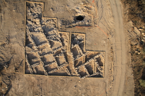
Aerial photographs. Photo credit: Skyview, courtesy of the Israel Antiquities Authority
The remnants of a rural settlement that was occupied for approximately two centuries during the Second Temple Period were uncovered in August 2013 – January 2014 near the 'Burma Road' (not far from Mitzpe Harel). The find was made during an Israel Antiquities Authority archaeological salvage excavation, before the start of work on a natural gas pipeline to Jerusalem as part of a national project directed by Israel Natural Gas Lines (INGL).
In June 2013, Israel Natural Gas Lines began construction of the 35km-long project, which runs from the coastal plain to the outskirts of Jerusalem. In light of the finds, the Israel Antiquities Authority and the INGL have agreed that engineering plans for the gas line are to be revised, bypassing the site and preserving it as an accessible archaeological site beside the Burma Road.
The excavations, which covered about 750 square meters, revealed a small rural settlement with a few stone houses and a network of narrow alleys. Each building, which probably housed a single nuclear family, consisted of several rooms and an open courtyard. According to Irina Zilberbod, excavation director on behalf of the Antiquities Authority, "The rooms generally served as residential and storage rooms, while domestic tasks were carried out in the courtyards".
The site, whose name has not survived, is nestled at the top of a spur 280 meters above sea level, with commanding views of the surrounding countryside. These large tracts of land were used as they are today to cultivate orchards and vineyards, which were the economic mainstay of the region’s early settlers.
The excavations have shown that the site reached the height of its development in the Hellenistic period (during the third century BCE), when Judea was ruled by the Seleucid monarchy following Alexander the Great, and that it was abandoned at the end of the Hasmonean dynasty.
It is not known why the site was abandoned, but it is probably related to economic problems and not to a violent incident. As Jerusalem Regional Archaeologist Dr. Yuval Baruch explains, "The phenomenon of villages and farms being abandoned at the end of the Hasmonean dynasty or the beginning of Herod the Great's succeeding rule is one that we are familiar with from many rural sites in Judea, and it may be related to Herod's massive building projects in Jerusalem, particularly the construction of the Temple Mount, and the mass migration of villagers to the capital to work on these projects."
The excavations yielded numerous and varied finds from all occupation periods, including basalt and limestone grinding and milling tools for domestic use, pottery cooking pots, jars for storing liquids (oil and wine,) pottery oil lamps for domestic use, and over sixty coins, including coins from the reigns of the Seleucid King Antiochus III and the Hasmonean King Alexander Jannaeus.

Coin from the reign of King Antiochus III. Photo: Clara Amit, courtesy of the Israel Antiquities Authority
Saturday, February 15, 2014
Earliest evidence of human footprints outside Africa discovered
Extraordinary find of 800,000 year old footprints In England makes a direct connection to the earliest humans in northern Europe
A team of scientists led by the British Museum, Natural History Museum and Queen Mary University of London have discovered a series of footprints left by early humans in ancient estuary muds over 800,000 years ago at Happisburgh in Norfolk, The footprints are direct evidence of the earliest known humans in northern Europe. The new evidence, published today in the science journal PLOS ONE reveals how the footprints were discovered and recorded on the foreshore at Happisburgh during May 2013.
The footprint surface was exposed at low tide as heavy seas removed the beach sands to reveal a series of elongated hollows cut into compacted silts. "At first we weren’t sure what we were seeing," explains Dr Nick Ashton of the British Museum "but as we removed any remaining beach sand and sponged off the seawater, it was clear that the hollows resembled prints, perhaps human footprints, and that we needed to record the surface as quickly as possible before the sea eroded it away." Over the next two weeks the surface was recorded using photogrammetry, a technique that can stitch together digital photographs to create a permanent record and 3D images of the surface. It was the analysis of these images that confirmed that the elongated hollows were indeed ancient human footprints, perhaps of five individuals. Ashton concludes "this is an extraordinarily rare discovery. The Happisburgh site continues to re-write our understanding of the early human occupation of Britain and indeed of Europe".
The analyses showed that the prints were from a range of adult and juvenile foot sizes and that in some cases the heel, arch and even toes could be identified, equating to modern shoes of up to UK size 8. Dr Isabelle De Groote from Liverpool John Moores University studied the prints in more detail. "In some cases we could accurately measure the length and width of the footprints and estimate the height of the individuals who made them. In most populations today and in the past foot length is approximately 15% of height. We can therefore estimate that the heights varied from about 0.9 m to over 1.7 m. This height range suggests a mix of adults and children with the largest print possibly being a male." The orientation of the footprints suggests that they were heading in a southerly direction.
Over the last ten years the sediments at Happisburgh have revealed a series of sites with stone tools and fossil bones, dating back to over 800,000 years. This latest discovery is from the same deposits. "Although we knew that the sediments were old, we had to be certain that the hollows were also ancient and hadn’t been created recently." Say Dr Simon Lewis, a geoarchaeologist at Queen Mary University of London. "There are no known erosional processes that create that pattern. In addition, the sediments are too compacted for the hollows to have been made recently."
The age of the site is based on its geological position beneath the glacial deposits that form the cliffs, but also the association with extinct animals. Simon Parfitt of the Natural History Museum and University College London has studied the mammalian fossils from Happisburgh. "These include an extinct type of mammoth, extinct horse and early forms of vole. Together they support an age of over 800,000 years." The site also preserves plant remains and pollen, together with beetles and shells, which allows a detailed reconstruction of the landscape. At this time Britain was linked by land to continental Europe and the site at Happisburgh would have been on the banks of a wide estuary several miles from the coast. There would have been muddy freshwater pools on the floodplain with salt marsh and coast nearby. Deer, bison, mammoth, hippo and rhino grazed the river valley, surrounded by more dense coniferous forest. The estuary provided a rich array of resources for the early humans with edible plant tubers, seaweed and shellfish nearby, while the grazing herds would have provided meat through hunting or scavenging.
So who were these humans? Fossil remains of our forebears are still proving elusive. However, as Professor Chris Stringer of the Natural History Museum explains "The humans who made the Happisburgh footprints may well have been related to the people of similar antiquity from Atapuerca in Spain, assigned to the species Homo antecessor ('Pioneer Man'). These people were of a similar height to ourselves and were fully bipedal. They seem to have become extinct in Europe by 600,000 years ago and were perhaps replaced by the species Homo heidelbergensis. Neanderthals followed from about 400,000 years ago, and eventually modern humans some 40,000 years ago."
The importance of the Happisburgh footprints is highlighted by the rarity of footprints surviving elsewhere. Only those at Laetoli in Tanzania at about 3.5 million years and at Ileret and Koobi Fora in Kenya at about 1.5 million years are more ancient. As Nick Ashton concludes "these footprints provide a very tangible link to our forebears and deep past." The work at Happisburgh continues, but as the cliffs erode, new sites are being discovered, but also destroyed by the encroaching sea. The footprints were unfortunately rapidly eroded away, but it is hoped that new footprints will be revealed in the future.
The work at Happisburgh forms part of a new major exhibition at the Natural History Museum Britain: One Million Years of the Human Story opening on 13 February 2014.
Wednesday, February 12, 2014
Clovis boy's family is the direct ancestor to 80 % of all present day Native Americans
America's only Clovis skeleton had its genome mapped
They lived in America about 13,000 years ago where they hunted mammoth, mastodons and giant bison with big spears. The Clovis people were not the first humans in America, but they represent the first humans with a wide expansion on the North American continent – until the culture mysteriously disappeared only a few hundred years after its origin. Who the Clovis people were and which present day humans they are related to has been discussed intensely and the issue has a key role in the discussion about how the Americas were peopled. Today there exists only one human skeleton found in association with Clovis tools and at the same time it is among the oldest human skeletons in the Americas. It is a small boy between 1 and 1.5 years of age – found in a 12,600 old burial site, called the Anzick Site, in Wilsall, Montana, USA. Now an international team headed by Danish researcher Eske Willerslev has mapped his genome thereby reviving the scientific debate about the colonization of the Americas.
Roughly estimated some 80 % of all present-day Native American populations on the two American continents are direct descendants of the Clovis boy's family. The remaining 20 % are more closely related with the Clovis family than any other people on Earth, says Lundbeck Professor Eske Willerslev from the Centre for GeoGenetics at the Natural History Museum of Denmark, University of Copenhagen. This surprising result has now been published in the scientific journal Nature. The discovery is so decisive that Nature has chosen to send the article to the press at a later time than usual as they fear the media embargo may be broken. A comprehensive international telephone press conference has been arranged and will be held in the Crow tribe's reservation in Montana – close to where the boy was found. Behind the results are a group of international researchers led by Professor Eske Willerslev from Centre of Excellence in GeoGenetics, Natural History Museum at University of Copenhagen, Denmark.
The missing link
It is almost like finding the 'missing link' to the common ancestor of the Native Americans. The Clovis boy's family is the direct ancestor to roughly estimated 80 % of all present day Native Americans. Although the Clovis culture disappeared its people are living today. Put simply it is a sensation that we succeeded in finding an approximately 12,600 year old boy whose closest relatives can be regarded as the direct ancestor to so many people, Eske Willerslev says and adds:
This also means that Clovis did not descend from Europeans, Asians or Melanesians, a theory that a number of scientists have advocated. They were Native Americans – and the Native American ancestors were the first people in America. This is now a fact.
Shane Doyle, a historian from the Apsaalooke (Crow) tribe, who helped the team with consultations to the Montana tribes agrees:
This discovery by Eske and his team proves something that tribal people have never doubted - we've been here since time immemorial and all the ancient artifacts located within our homelands are remnants from our direct ancestors. But the discovery is only part of the importance of this study. The other part being Eske and his team's respectful commitment to interacting face to face with tribal communities and listening to Native American leaders, which has lead directly to the reburial of this little boy."
Also Sarah Anzick, a molecular biologist in the study and the steward of the remains that were found on private land is excited:
After 46 years since the discovery on my family land, we are finally hearing this child's story through his genetic legacy. I find it remarkable that the descendants of the Clovis culture, which seemed to have vanished 12,600 years ago, are still alive and thriving today.
Interestingly, the teams find that Native American ancestors coming in from Siberia split into two groups. One group is ancestors to the Native Americans presently living in Canada and the other one – which is represented by the Clovis boy – is the ancestor to virtually all Native Americans in South America and Mexico. The US is still a white spot on the map when it comes to genome-wide data from Native Americans. The team members hope to be able to accessing such data in the future to understand the full picture.
The study validates the concept of continuity in the history of Native Americans, and suggests that modern Native Americans are direct descendants of the first people occupying this land, says Rasmus Nielsen, a co-author on the study and a Professor at UC Berkeley, who developed the method used for determining that many modern native Americans are direct descendants of the Clovis boy's family.
An Asian homeland for the First Americans
The first humans came from Siberia via the so-called Beringia Land Bridge, which during the latest ice age connected Siberia with North America and did not bring the Clovis culture with them. The Clovis culture arose after they arrived in America and the boy from Anzick was more a descendant of the first immigrants.
Michael Waters, the key archaeologist connected to the study and who has worked on many Clovis and older sites in North America elaborates:
The genetic findings mesh well with the archaeological evidence to confirm the Asian homeland of the First Americans, more clearly define their genetic heritage, and is consistent with occupation of the Americas a few thousand years before Clovis. The findings do not support a western European origin of the First Americans as suggested by the Solutrean hypothesis. The genetic information provided by the Anzick boy is part of the larger story of modern human dispersal across the Earth and is shedding new light on the last continent to be explored and settled by our species.
Then who were the first immigrants? We don't know. Yet. Maybe a Native American, maybe an ancestor related to the Mal'ta boy from Siberia and another one who was East Asian. We don't know. But our results eliminate all other theories about the origins of the first people in America. The first people in America were the direct ancestors of Native Americans, says Professor Willerslev and continues:
We can see that the Clovis boy shares about 1/3 of his genes with the 24,000 year old child from Mal'ta at the Siberian Lake Baikal who we have analyzed previously. The same goes for all present day Native Americans. Therefore the encounter between East Asians and the Mal'ta group happened before Clovis.
The human remains from the Anzick site will be reburied sometime this year in cooperation with Native American tribes in Montana. Eske Willerslev has in connection with the genome work on the Clovis boy visited several of Montana's Native American tribes with Crow historian Shane Doyle to discuss the findings. All the members of the research team hope that the Anzick study leads to more and enhanced cooperation between Native peoples and scientists. Therefore he has also chosen the Crow reservation in Montana to hold the press conference.
Monday, February 3, 2014
Israel's First Camels
Archaeologists pinpoint the date when domesticated camels arrived in Israel
Camels are mentioned as pack animals in the biblical stories of Abraham, Joseph, and Jacob. But archaeologists have shown that camels were not domesticated in the Land of Israel until centuries after the Age of the Patriarchs (2000-1500 BCE). In addition to challenging the Bible's historicity, this anachronism is direct proof that the text was compiled well after the events it describes.
Now Dr. Erez Ben-Yosef and Dr. Lidar Sapir-Hen of Tel Aviv University's Department of Archaeology and Near Eastern Cultures have used radiocarbon dating to pinpoint the moment when domesticated camels arrived in the southern Levant, pushing the estimate from the 12th to the 9th century BCE. The findings, published recently in the journal Tel Aviv, further emphasize the disagreements between Biblical texts and verifiable history, and define a turning point in Israel's engagement with the rest of the world.
"The introduction of the camel to our region was a very important economic and social development," said Dr. Ben-Yosef. "By analyzing archaeological evidence from the copper production sites of the Aravah Valley, we were able to estimate the date of this event in terms of decades rather than centuries."
Copper mining and camel riding
Archaeologists have established that camels were probably domesticated in the Arabian Peninsula for use as pack animals sometime towards the end of the 2nd millennium BCE. In the southern Levant, where Israel is located, the oldest known domesticated camel bones are from the Aravah Valley, which runs along the Israeli-Jordanian border from the Dead Sea to the Red Sea and was an ancient center of copper production. At a 2009 dig, Dr. Ben-Yosef dated an Aravah Valley copper smelting camp where the domesticated camel bones were found to the 11th to 9th century BCE. In 2013, he led another dig in the area.
To determine exactly when domesticated camels appeared in the southern Levant, Dr. Sapir-Hen and Dr. Ben-Yosef used radiocarbon dating and other techniques to analyze the findings of these digs as well as several others done in the valley. In all the digs, they found that camel bones were unearthed almost exclusively in archaeological layers dating from the last third of the 10th century BCE or later — centuries after the patriarchs lived and decades after the Kingdom of David, according to the Bible. The few camel bones found in earlier archaeological layers probably belonged to wild camels, which archaeologists think were in the southern Levant from the Neolithic period or even earlier. Notably, all the sites active in the 9th century in the Aravah Valley had camel bones, but none of the sites that were active earlier contained them.
The appearance of domesticated camels in the Aravah Valley appears to coincide with dramatic changes in the local copper mining operation. Many of the mines and smelting sites were shut down; those that remained active began using more centralized labor and sophisticated technology, according to the archaeological evidence. The researchers say the ancient Egyptians may have imposed these changes — and brought in domesticated camels — after conquering the area in a military campaign mentioned in both biblical and Egyptian sources.
Humping it to India
The origin of the domesticated camel is probably the Arabian Peninsula, which borders the Aravah Valley and would have been a logical entry point for domesticated camels into the southern Levant. In fact, Dr. Ben-Yosef and Dr. Sapir-Hen say the first domesticated camels ever to leave the Arabian Peninsula may now be buried in the Aravah Valley.
The arrival of domesticated camels promoted trade between Israel and exotic locations unreachable before, according to the researchers; the camels can travel over much longer distances than the donkeys and mules that preceded them. By the seventh century BCE, trade routes like the Incense Road stretched all the way from Africa through Israel to India. Camels opened Israel up to the world beyond the vast deserts, researchers say, profoundly altering its economic and social history.
Subscribe to:
Posts (Atom)