Tuesday, May 29, 2012
Climate change led to collapse of ancient Indus civilization
A new study combining the latest archaeological evidence with state-of-the-art geoscience technologies provides evidence that climate change was a key ingredient in the collapse of the great Indus or Harappan Civilization almost 4000 years ago. The study also resolves a long-standing debate over the source and fate of the Sarasvati, the sacred river of Hindu mythology.
Once extending more than 1 million square kilometers across the plains of the Indus River from the Arabian Sea to the Ganges, over what is now Pakistan, northwest India and eastern Afghanistan, the Indus civilization was the largest—but least known—of the first great urban cultures that also included Egypt and Mesopotamia. Like their contemporaries, the Harappans, named for one of their largest cities, lived next to rivers owing their livelihoods to the fertility of annually watered lands.
"We reconstructed the dynamic landscape of the plain where the Indus civilization developed 5200 years ago, built its cities, and slowly disintegrated between 3900 and 3000 years ago," said Liviu Giosan, a geologist with Woods Hole Oceanographic Institution (WHOI) and lead author of the study published the week of May 28 in the Proceedings of the National Academy of Sciences. "Until now, speculations abounded about the links between this mysterious ancient culture and its life-giving mighty rivers."
Today, numerous remains of the Harappan settlements are located in a vast desert region far from any flowing river. In contrast to Egypt and Mesopotamia, which have long been part of the Western classical canon, this amazingly complex culture in South Asia with a population that at its peak may have reached 10 percent of the world's inhabitants, was completely forgotten until 1920's. Since then, a flurry of archaeological research in Pakistan and India has uncovered a sophisticated urban culture with myriad internal trade routes and well-established sea links with Mesopotamia, standards for building construction, sanitation systems, arts and crafts, and a yet-to-be deciphered writing system.
"We considered that it is high time for a team of interdisciplinary scientists to contribute to the debate about the enigmatic fate of these people," added Giosan.
The research was conducted between 2003 and 2008 in Pakistan, from the coast of the Arabian Sea into the fertile irrigated valleys of Punjab and the northern Thar Desert. The international team included scientists from the U.S., U.K., Pakistan, India, and Romania with specialties in geology, geomorphology, archaeology, and mathematics. By combining satellite photos and topographic data collected by the Shuttle Radar Topography Mission (SRTM), the researchers prepared and analyzed digital maps of landforms constructed by the Indus and neighboring rivers, which were then probed in the field by drilling, coring, and even manually-dug trenches. Collected samples were used to determine the sediments' origins, whether brought in and shaped by rivers or wind, and their age, in order to develop a chronology of landscape changes.
"Once we had this new information on the geological history, we could re-examine what we know about settlements, what crops people were planting and when, and how both agriculture and settlement patterns changed," said co-author Dorian Fuller, an archaeologist with University College London. "This brought new insights into the process of eastward population shift, the change towards many more small farming communities, and the decline of cities during late Harappan times."
The new study suggests that the decline in monsoon rains led to weakened river dynamics, and played a critical role both in the development and the collapse of the Harappan culture, which relied on river floods to fuel their agricultural surpluses.
From the new research, a compelling picture of 10,000 years of changing landscapes emerges. Before the plain was massively settled, the wild and forceful Indus and its tributaries flowing from the Himalaya cut valleys into their own deposits and left high "interfluvial" stretches of land between them. In the east, reliable monsoon rains sustained perennial rivers that crisscrossed the desert leaving behind their sedimentary deposits across a broad region.
Among the most striking features the researchers identified is a mounded plain, 10 to 20 meters high, over 100 kilometers wide, and running almost 1000 kilometers along the Indus, they call the "Indus mega-ridge," built by the river as it purged itself of sediment along its lower course.
"At this scale, nothing similar has ever been described in the geomorphological literature," said Giosan. "The mega-ridge is a surprising indicator of the stability of Indus plain landscape over the last four millennia. Remains of Harappan settlements still lie at the surface of the ridge, rather than being buried underground."
Mapped on top of the vast Indo-Gangetic Plain, the archaeological and geological data shows instead that settlements bloomed along the Indus from the coast to the hills fronting the Himalayas, as weakened monsoons and reduced run-off from the mountains tamed the wild Indus and its Himalayan tributaries enough to enable agriculture along their banks.
"The Harappans were an enterprising people taking advantage of a window of opportunity – a kind of "Goldilocks civilization," said Giosan. "As monsoon drying subdued devastating floods, the land nearby the rivers - still fed with water and rich silt - was just right for agriculture. This lasted for almost 2,000 years, but continued aridification closed this favorable window in the end."
In another major finding, the researchers believe they have settled a long controversy about the fate of a mythical river, the Sarasvati. The Vedas, ancient Indian scriptures composed in Sanskrit over 3000 years ago, describe the region west of the Ganges as "the land of seven rivers." Easily recognizable are the Indus and its current tributaries, but the Sarasvati, portrayed as "surpassing in majesty and might all other waters" and "pure in her course from mountains to the ocean," was lost. Based on scriptural descriptions, it was believed that the Sarasvati was fed by perennial glaciers in the Himalayas. Today, the Ghaggar, an intermittent river that flows only during strong monsoons and dissipates into the desert along the dried course of Hakra valley, is thought to best approximate the location of the mythic Sarasvati, but its Himalayan origin and whether it was active during Vedic times remain controversial.
Archaeological evidence supports the Ghaggar-Hakra as the location of intensive settlement during Harappan times. The geological evidence—sediments, topography— shows that rivers were indeed sizable and highly active in this region, but most likely due to strong monsoons. There is no evidence of wide incised valleys like along the Indus and its tributaries and there is no cut-through, incised connections to either of the two nearby Himalayan-fed rivers of Sutlej and Yamuna. The new research argues that these crucial differences prove that the Sarasvati (Ghaggar-Hakra) was not Himalayan-fed, but a perennial monsoon-supported watercourse, and that aridification reduced it to short seasonal flows.
By 3900 years ago, their rivers drying, the Harappans had an escape route to the east toward the Ganges basin, where monsoon rains remained reliable.
"We can envision that this eastern shift involved a change to more localized forms of economy: smaller communities supported by local rain-fed farming and dwindling streams," said Fuller. "This may have produced smaller surpluses, and would not have supported large cities, but would have been reliable."
Such a system was not favorable for the Indus civilization, which had been built on bumper crop surpluses along the Indus and the Ghaggar-Hakra rivers in the earlier wetter era. This dispersal of population meant that there was no longer a concentration of workforce to support urbanism. "Thus cities collapsed, but smaller agricultural communities were sustainable and flourished. Many of the urban arts, such as writing, faded away, but agriculture continued and actually diversified," said Fuller.
"An amazing amount of archaeological work has been accumulating over the last decades, but it's never been linked properly to the evolution of the fluvial landscape. We now see landscape dynamics as the crucial link between climate change and people," said Giosan. "Today the Indus system feeds the largest irrigation scheme in the world, immobilizing the river in channels and behind dams. If the monsoon were to increase in a warming world, as some predict, catastrophic floods such as the humanitarian disaster of 2010, would turn the current irrigation system, designed for a tamer river, obsolete."
Friday, May 25, 2012
Oldest Jewish archaeological evidence on the Iberian Peninsula

Archeologists of the Jena University found this marble plate with a Hebrew inscription at an excavation site in the south of Portugal. Credit: Photo: Dennis Graen/FSU
On a marble plate, measuring 40 by 60 centimetres, the name "Yehiel" can be read, followed by further letters which have not yet been deciphered. The Jena Archaeologists believe that the new discovery might be a tomb slab. Antlers, which were found very close to the tomb slab in the rubble gave a clue to the age determination. "The organic material of the antlers could be dated by radiocarbon analysis with certainty to about 390 AD," excavation leader Dr. Dennis Graen of the Jena University explains. "Therefore we have a so-called 'terminus ante quem' for the inscription, as it must have been created before it got mixed in with the rubble with the antlers."
The earliest archaeological evidence of Jewish inhabitants in the region of modern-day Portugal has so far also been a tomb slab with a Latin inscription and an image of a menorah - a seven-armed chandelier - from 482 AD. The earliest Hebrew inscriptions known until now date from the 6th or 7th Century AD.

The place of discovery is a Roman villa near Silves. Credit: Photo: Dennis Graen/FSU
For three years the team of the University Jena has been excavating a Roman villa in Portugal, discovered some years ago by Jorge Correia, archaeologist of the Silves council, during an archaeological survey near the village of São Bartolomeu de Messines (Silves). The project was aiming at finding out how and what the inhabitants of the hinterland of the Roman province of Lusitania lived off. While the Portuguese coast region has been explored very well, there is very little knowledge about those regions. The new discovery poses further conundrums. "We were actually hoping for a Latin inscription when we turned round the excavated tomb slab," Henning Wabersich, a member of the excavation reports. After all, no inscriptions have been found so far and nothing was known about the identity of the inhabitants of the enclosure. Only after long research the Jena Archaeologists found out which language they were exactly dealing with, as the inscription was not cut with particular care. "While we were looking for experts who could help with deciphering the inscription between Jena and Jerusalem, the crucial clue came from Spain" Dennis Graen says. "Jordi Casanovas Miró from the Museu Nacional d'Art de Catalunya in Barcelona – a well-known expert for Hebrew inscriptions on the Iberian Peninsula – is sure that the Jewish name "Yehiel" can be read, - a name that is already mentioned in the Bible."
Not only is the early date exceptional in this case, but also the place of the discovery: Never before have Jewish discoveries been made in a Roman villa, the Jena Archaelogist explains. In the Roman Empire at that time Jews usually wrote in Latin, as they feared oppressive measures. Hebrew, as on the re-discovered marble plate, only came back into use after the decline of the Roman supremacy, respectively in the following time of migration of peoples from the 6th or 7th century AD. "We were also most surprised that we found traces of Romans - romanised Lusitanians in this case - and Jews living together in a rural area of all things," Dennis Graen says. "We assumed that something like this would have been much more likely in a city."
Information about the Jewish population in the region in general was mostly passed down by scriptures. "During the ecclesiastical council in the Spanish town Elvira about 300 AD rules of conduct between Jews and Christians were issued. This indicates that at this time there must have been a relatively large number of Jews on the Iberian Peninsula already", Dennis Graen explains – but archaeological evidence had been missing so far. "We knew that there was a Jewish community in the Middle Ages not far from our excavation site in the town of Silves. It existed until the expulsion of the Jews in the year 1497."
In the summer the Jena Archaeologists will take up their work again. Until now they have excavated 160 square metres of the villa, but after checking out the ground it already became clear that the greater part of the enclosure is still covered in soil. "We eventually want to find out more about the people who lived here," Graen explains the venture. "And of course we want to solve the questions the Hebrew inscription has posed us."
Monday, May 21, 2012
Unique Gold Earring Found at Tel Megiddo

According to Prof. Israel Finkelstein of TAU's Department of Archaeology and Near Eastern Cultures, the vessel was found in 2010, but remained uncleaned while awaiting a molecular analysis of its content. When they were finally able to wash out the dirt, pieces of jewelry, including a ring, earrings, and beads, flooded from the vessel. Prof. Finkelstein is the co-director of the excavation of Tel Megiddo along with Professor Emeritus David Ussishkin of Tel Aviv University and Associate Director Prof. Eric Cline of George Washington University in Washington, D.C.
The researchers believe that the collection, which was discovered in the remains of a private home in the northern part of Megiddo, belongs to a time period called "Iron I," and that at least some of the pieces could have originated in nearby Egypt. Some of the materials and designs featured in the jewelry, including beads made from carnelian stone, are consistent with Egyptian designs from the same period, notes Ph.D. candidate Eran Arie, who supervises the area where the hoard was found.
A treasure trove with mysterious origins
When the researchers removed the ceramic jug from the excavation site, they had no idea there was jewelry hidden within. The jewelry was well preserved and wrapped in textiles, but the circumstances surrounding it are mysterious. According to Prof. Finkelstein, it is likely that the jug was not the jewelry's normal storage place. "It's clear that people tried to hide the collection, and for some reason they were unable to come back to pick it up." The owners could have perished or been forced to flee, he says. Prof. Ussishkin believes that it was the jewelry collection of the Canaanite woman who lived in the house.
The assortment of jewelry is also out of the ordinary, notes Arie. Though the collection includes a number of lunette (moon-shaped) earrings of common Canaanite origin, researchers found an abundance of gold items in the collection and a number of beads made from carnelian, which was frequently used in the making of Egyptian jewellery in the same period. This points to a strong Egyptian connection, whether in influence or origin. Such a connection would not be surprising, according to Prof. Cline, who stated that interactions between Egypt and Megiddo are known to have taken place during both the Bronze Age and the Iron Age.
The most notable piece, the researchers agree, is a gold earring with a pattern of molded wild goats. "For unique items, we work to find parallels to help place the items in their correct cultural and chronological settings, but in this case we still haven't found anything," say the researchers.
Adding dimension to a multi-layer dig
It's another fascinating find from a unique archaeological site. Tel Megiddo was an important Canaanite city-state until the early 10th century B.C.E. and a pivotal center of the Northern Kingdom of Israel in the 9th and 8th centuries B.C.E. It is a multi-layered site with various time periods clearly differentiated, and in this time period there are 10 to 11 strata well-dated through radiocarbon analysis. "Such a sequence of radiocarbon dates doesn't exist anywhere else in the region," says Prof. Finkelstein.
The layer in which the jewelry was found has already been dated to the 11th century B.C., just after the end of Egyptian rule in the 12th century B.C., Arie says. Either the jewelry was left behind in the Egyptian withdrawal or the people who owned the jewelry were influenced by Egyptian culture.
The researchers hope that analysis of both the textiles in which the jewelry was wrapped and the jewelry itself will tell them more about the origins of the collection. If the gold is pure rather than a mixture of gold and silver, for example, the metal most likely will have come from Egypt itself, a region that was poor in silver resources but rich in gold.
Wednesday, May 16, 2012
Excavating Tel Kedesh
Complete article
Tel Kedesh is an enormous mound located in the rural interior of Israel’s Upper Galilee region. It is more than half a mile north to south. It is a double mound, with an upper tell occupied since the Early Bronze Age (3150–2300 B.C.) and a plateau-like lower tell likely constructed in the Middle Bronze Age (2300–1550 B.C.)...
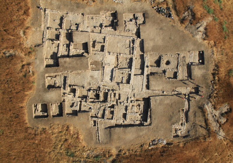
An aerial view shows the immense administrative building constructed around 500 B.C. and used until the 2nd century B.C. as it appeared after more than 10 years of excavation. (Courtesy Pascal Partouche, Skyview Photography, Ltd. We christened this the Hellenistic Administrative Building, on the basis of the granary and the archive, both administrative features.
Digging in the opposing southeastern and northwestern corners revealed that it was one enormous complex. The room next to the northwestern corner had a plastered floor, several wine jars from the Greek island of Rhodes, and 14 huge jars, almost five feet tall each, leaning against the walls. With permission from the Israel Antiquities Authority, we took the broken bottoms of two jars back to the United States for residue analysis and discovered phytoliths—mineral secretions left by plants after they decay—of Triticum aestivum (bread wheat). It was clear that this building had been a storeroom for wine and grain—lots of grain. Each jar held almost 25 gallons, which, once ground into flour, would produce about 150 loaves of bread.
Additional surprises came to light around the corner where we found more than 40 amphoriskoi (small, two-handled flasks) and about 1,500 tiny stamped clay lumps, or bullae. The bullae carry images including those of Greek deities, Seleucid kings, and animals and symbols. They have string holes through the sides and the neat linear impressions of papyrus on the back, both indications that they originally sealed rolled-up papyrus documents. The quantity of bullae in the room indicated that it once housed a sizeable archive. While none of the documents survive, the bullae themselves provide clues about who sent the texts and who officially approved them...
The hundreds of useful objects that were left behind in the building, including more than 20 Rhodian wine jars, continued to confirm that it had been abandoned very quickly. The wine vessels have handles stamped with the names of officials, each of whose tenures can be dated with great accuracy. The latest jars date to 144 or 143 B.C. According to 1 Maccabees 11:63–73, at that time there was a battle in the valley below the Kedesh plateau between the Hasmonean leader Jonathan (the Hasmoneans were a family of high priests and kings who ruled the Jewish state of Judea between 167 and 37 B.C.) and the Seleucid king Demetrius. Jonathan’s forces pursued the Seleucids to Kedesh, killed many, and camped there for several days before leaving for Jerusalem. It appears that the hastily abandoned remains found throughout the building are a result of that battle...
More on Evidence of a Cult in Judah at Time of King David
Complete article
Archaeologists in an Uproar Over David-and-Goliath-Era Finds at the Contested Edge of Jerusalem

Scholars hope that recent discoveries at Khirbet Qeiyafa, an archeological site southwest of Jerusalem, will shed new light on the ancient history of present-day Israel, and even corroborate the story of David and Goliath recounted in the Bible. Though leaving ample room for debate, Yosef Garfinkel, an archaeologist at the Hebrew University of Jerusalem, has told MSNBC that several objects found by his team strongly suggest the heretofore disputed presence of Israelites from the southern kingdom of Judea...
Garfinkel contends that his finds confirm that Khirbet Qeiyafa was an embattled outpost occupied by Israelites during the time of David. By his estimation, the columns, façades, and recessed doorways on the model shrines found at the site correspond strikingly to Solomon's temple. "For the first time in history," reads a statement from the Hebrew University, "we have actual objects from the time of David which can be related to monuments described in the Bible." Garfinkel furthermore points out that although archaeologists at the site have found thousands of bones of sheep, goats, and cattle, they have found no bones from pigs, which may suggest a dietary prohibition on swine like that observed by Hebrews.
While the news has made headlines across Israel, Garfinkel has failed to convince many Biblical scholars who know Khirbet Qeiyafa well. Prof. Nadav Na'aman, a historian and archaeologist at Tel Aviv University, was unmoved by the lack of pig bones at the site. "The Canaanites also did not eat pork," he told Ha'aretz. "Only the Philistines ate a great deal of pork at this time." Responding to Garfinkel's description of the artifacts as "totally different from Philistine, Canaanite or the cult in the Kingdom of Israel," Aren Maeir of Bar-Ilan University told the Times of Israel that that Biblical distinctions between Israelites and Philistines are "fuzzier than the way they are often described."
Tuesday, May 15, 2012
Anthropologists discover earliest form of wall art
Anthropologists working in southern France have determined that a 1.5 metric ton block of engraved limestone constitutes the earliest evidence of wall art. Their research, reported in the most recent edition of the Proceedings of the National Academy of Sciences, shows the piece to be approximately 37,000 years old and offers rich evidence of the role art played in the daily lives of Early Aurignacian humans.
The research team, comprised of more than a dozen scientists from American and European universities and research institutions, has been excavating at the site of the discovery—Abri Castanet—for the past 15 years. Abri Castanet and its sister site Abri Blanchard have long been recognized as being among the oldest sites in Eurasia bearing artifacts of human symbolism. Hundreds of personal ornaments have been discovered, including pierced animal teeth, pierced shells, ivory and soapstone beads, engravings, and paintings on limestone slabs.
"Early Aurignacian humans functioned, more or less, like humans today," explained New York University anthropology professor Randall White, one of the study's co-authors. "They had relatively complex social identities communicated through personal ornamentation, and they practiced sculpture and graphic arts."
Aurignacian culture existed until approximately 28,000 years ago.
In 2007, the team discovered an engraved block of limestone in what had been a rock shelter occupied by a group of Aurignacian reindeer hunters. Subsequent geological analysis revealed the ceiling had been about two meters above the floor on which the Aurignacians lived—within arms' reach.
Using carbon dating, the researchers determined that both the engraved ceiling, which includes depictions of animals and geometric forms, and the other artifacts found on the living surface below were approximately 37,000 years old.
"This art appears to be slightly older than the famous paintings from the Grotte Chauvet in southeastern France," explained White, referring to the cave paintings discovered in 1994.
"But unlike the Chauvet paintings and engravings, which are deep underground and away from living areas, the engravings and paintings at Castanet are directly associated with everyday life, given their proximity to tools, fireplaces, bone and antler tool production, and ornament workshops."
He added that this discovery, combined with others of approximately the same time period in southern Germany, northern Italy, and southeastern France, raises new questions about the evolutionary and adaptive significance of art and other forms of graphic representation in the lives of modern human populations.
Saturday, May 12, 2012
Remains were Discovered of the Closest Building to the First Temple
On its Floor – a Hebrew Seal Bearing the Name ‘Matanyahu’
In the excavations, underwritten by the Ir David Foundation, a personal Hebrew seal from the end of the First Temple period was discovered on the floor of the ancient building. The seal is made of a semi-precious stone and is engraved with the name of its owner: “Lematanyahu Ben Ho…” ("למתניהו בן הו..." meaning: “Belonging to Matanyahu Ben Ho…”). The rest of the inscription is erased.
From the very start of the excavations in this area the archaeologists decided that all of the soil removed from there would be meticulously sifted (including wet-sifting and thorough sorting of the material remnants left in the sieve).
People used personal seals in the First Temple period for the purpose of signing letters and they were set in a signet ring. The seals served to identify their owner, just as they identify officials today.
According to Eli Shukron, excavation director on behalf of the Israel Antiquities Authority, “the name Matanyahu, like the name Netanyahu, means giving to God. These names are mentioned several times in the Bible. They are typical of the names in the Kingdom of Judah in latter part of the First Temple period – from the end of the eighth century BCE until the destruction of the Temple in 586 BCE. To find a seal from the First Temple period at the foot of the Temple Mount walls is rare and very exciting. This is a tangible greeting of sorts from a man named Matanyahu who lived here more than 2,700 years ago. We also found pottery sherds characteristic of the period on the floor in the ancient building beneath the base of the drainage channel, as well as stone collapse and evidence of a fire”.
Subscribe to:
Posts (Atom)