Tuesday, December 15, 2009

Herod the Great's Tomb

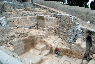
The long search for Herod the Great's tomb ended with the exposure of the remains of his grave, sarcophagus and mausoleum on Mount Herodium's northeastern slope.


Herod was the Roman-appointed king of Judea from 37 to 4 BCE, who was renowned for his many monumental building projects, including the reconstruction of the Temple in Jerusalem, the palace at Masada, as well as the complex at Herodium, 15 kilometers south of Jerusalem. .

Herodium is the most outstanding among King Herod's building projects. This is the only site that carries his name and the site where he chose to be buried and to memorialize himself -- all of this with the integration of a huge, unique palace at the fringe of the desert, said Prof. Netzer. Therefore, he said, the exposure of his tomb becomes the climax of this site's research.

The approach to the burial site - which has been described by the archaeologists involved as one of the most striking finds in Israel in recent years - was via a monumental flight of stairs (6.5 meters wide) leading to the hillside that were especially constructed for the funeral procession.

The excavations on the slope of the mountain, at whose top is the famed structure comprised of a palace, a fortress and a monument, commenced in August 2006. The expedition, on behalf of the Institute of Archaeology of the Hebrew University of Jerusalem, was conducted by Prof. Netzer, together with Yaakov Kalman and Roi Porath and with the participation of local Bedouins.

The location and unique nature of the findings, as well as the historical record, leave no doubt that this was Herod's burial site, said Prof. Netzer.

The mausoleum itself was almost totally dismantled in ancient times. In its place remained only part of its well built podium, or base, built of large white ashlars (dressed stone) in a manner and size not previously revealed at Herodium.

Among the many high quality architectural elements, mostly well decorated, which were spread among the ruins, is a group of decorated urns (made in the form of special jars that were used to store body ashes). Similar ones are to be found on the top of burial monuments in the Nabatean world. The urns had a triangular cover and were decorated on the sides.

Spread among the ruins are pieces of a large, unique sarcophagus (close to 2.5 meters long), made of a Jerusalemite reddish limestone, which was decorated by rosettes. The sarcophagus had a triangular cover, which was decorated on its sides. This is assumed with certainty to be the sarcophagus of Herod. Only very few similar sarcophagi are known in the country and can be found only in elaborate tombs such as the famous one at the King's Tomb on Selah a-Din Street in East Jerusalem. Although no inscriptions have been found yet at Herodium, neither on the sarcophagus nor in the building remains, these still might be found during the continuation of the dig.

Worthy of note is the fact that the sarcophagus was broken into hundreds of pieces, no doubt deliberately. This activity, including the destruction of the monument, apparently took place in the years 66-72 C.E. during the first Jewish revolt against the Romans, while Jewish rebels took hold of the site, according to Josephus and the archaeological evidence. The rebels were known for their hatred of Herod and all that he stood for, as a "puppet ruler" for the Romans.

The search for Herod's tomb, which actively began 30 years ago, focused until the middle of 2006 at Lower Herodium, in an area which was, no doubt, especially built for the funeral and burial of the king - the "Tomb Estate." In order to reveal there the remains from Herod's days, the expedition was "forced" to first expose a large complex of Byzantine structures (including a church), an effort that demanded many years of digging.

The Tomb Estate included two monumental buildings and a large ritual bath (mikveh) as well as the large route (350 meters long and 30 meters wide) which was prepared for the funeral. When no sign of the burial place itself was found within the Tomb Estate, the expedition started to search for it on the slope of the hill, although there seems to be no doubt that the initial intention of the king was to be buried in the estate and that only in a later stage of his life - apparently when he grew old - did he change his mind and asked to be buried within the artificial cone which gave the hill of Herodium its current volcano-shape.

The main historical source of the Second Temple's days, the historian Josephus Flavius, has described the site of Herodium in detail, as well as the funeral in the year 4 BCE, but not the tomb proper. He wrote as follows:

"The king's funeral next occupied his attention. Archelaus, omitting nothing that could contribute to its magnificence, brought forth all the royal ornaments to accompany the procession in honor of the deceased. The bier was of solid gold, studded with precious stones, and had a covering of purple, embroidered with various colors; on this lay the body enveloped in purple robe, a diadem encircling the head and surmounted by a crown of gold, the scepter beside his right hand.

Around the bier were Herod's sons and a large group of his relations; these were followed by the guards, the Thracian contingent, Germans and Gauls, all equipped as for war. The reminder of the troops marched in front, armed and in orderly array, led by their commanders and subordinate officers; behind these came five hundred of Herod's servants and freedmen, carrying spices. The body was thus conveyed for a distance of two hundred furlongs to Herodium, where, in accordance with the directions of the deceased, it was interred. So ended Herod's reign." Jewish Wars, 1,23,9

Prof. Netzer started his archaeological activity at Herodium in 1972, at first on a small scale. The scope of his work widened with the decision to turn Herodium (the mount together with Lower Herodium) into a national park, which was due to occupy 125 acres. (Until that stage only the mount was proclaimed as a national park and was operated by the Nature and Parks Authority.)

The enlargement of the park started in 1980; unfortunately the activity at the site stopped as a result of the first Intifada, but not before the complex of tunnels from the days of Bar-Kokhba, within the mount, were opened to the public. The archaeological excavations at the site, which also stopped in 1987, were renewed 10 years later and continued until 2000, and after a second break, were renewed at the end of 2005.

Underground Cave Dating From The Year 1 A.D.

An artificial underground cave, the largest in Israel, has been exposed in the Jordan Valley in the course of a survey carried out by the University of Haifa's Department of Archaeology. Prof. Adam Zertal, who headed the excavating team, reckons that this cave was originally a large quarry during the Roman and Byzantine era and was a "one of a kind." Various engravings were uncovered in the cave, including cross markings, and it is assumed that this could have been an early monastery.

"It is probably the site of "Galgala" from the historical Madaba Map," Prof. Zertal says.


The enormous and striking cave covers an area of approximately 1 acre: it is some 100 meters long and about 40 meters wide. The cave is located 4 km north of Jericho. The cave, which is the largest excavated by man to be discovered in Israel, was exposed in the course of an archaeological survey that the University of Haifa has been carrying out since 1978.

As with other discoveries in the past, this exposure is shrouded in mystery. "When we arrived at the opening of the cave, two Bedouins approached and told us not to go in as the cave is bewitched and inhabited by wolves and hyenas," Prof. Zertal relates. Upon entering, accompanied by his colleagues, he was surprised to find an impressive architectonic underground structure supported by 22 giant pillars. They discovered 31 cross markings on the pillars, an engraving resembling the zodiac symbol, Roman letters and an etching that looks like the Roman Legion's pennant. The team also discovered recesses in the pillars, which would have been used for oil lamps, and holes to which animals that were hauling quarried stones out of the cave could have been tied.

The cave's ceiling is some 3 meters high, but was originally probably about 4 meters high. According to Prof. Zertal, ceramics that were found and the engravings on the pillars date the cave to around 1-600 AD. "The cave's primary use had been as a quarry, which functioned for about 400-500 years. But other findings definitely indicate that the place was also used for other purposes, such as a monastery and possibly as a hiding place," Prof. Zertal explains.

The main question that arose upon discovering the cave was why a quarry was dug underground in the first place. "All of the quarries that we know are above ground. Digging down under the surface requires extreme efforts in hauling the heavy rocks up to the surface, and in this case the quarrying was immense. The question is, why?"

For a possible answer to this mystery, Prof. Zertal points to the famous Madaba map. This is a Byzantine mosaic map that was found in Jordan and is the most ancient map of the Land of Israel. Jerusalem and the Jordan Valley are depicted with precision on the map, and a site called Galgala is depicted next to a Greek inscription that reads "Dodekaliton", which translates as "Twelve Stones." This place is marked at a distance from Jericho that matches this cave's distance from the city.

According to the map, there is a church next to Dodekaliton; there are two ancient churches located nearby the newly discovered cave. According to Prof. Zertal, until now it has been hypothesized that the meaning of "Twelve Stones" related to the biblical verses that describe the twelve stones that the Children of Israel place in Gilgal. However, it could be that the reference is a description of the quarry that was dug where the Byzantines identified the Gilgal.

"During the Roman era, it was customary to construct temples of stones that were brought from holy places, and which were therefore also more valuable stones. If our assumption is correct, then the Byzantine identification of the place as the biblical Gilgal afforded the site its necessary reverence and that is also why they would have dug an underground quarry there," Prof. Zertal concludes. "But" he adds, "much more research is needed."

Enormous 'Foot-Shaped' Enclosures In Jordan Valley

Foot-shaped" structures have been revealed in the Jordan valley and are among the earliest sites that archeologists believe were built by the ancient people of Israel. The structures are thought to be symbolic of the biblical concept of ownership.


"The 'foot' structures that we found in the Jordan valley are the first sites that the People of Israel built upon entering Canaan and they testify to the biblical concept of ownership of the land with the foot," said archaeologist Prof. Adam Zertal of the University of Haifa, who headed the excavating team that exposed five compounds in the shape of an enormous "foot" -- likely to have been used at that time to mark ownership of territory.

The finding is believed to represent the first time that enclosed sites identified with the biblical sites termed in Hebrew "gilgal", which were used for assemblies, preparation for battle, and rituals, have been revealed in the Jordan valley. The Hebrew word "gilgal" (a camp or stone-structure), is mentioned thirty-nine times in the Bible. The stone enclosures were located in the Jordan valley and the hill country west of it. To this day, no archaeological site has been proposed to be identified with the gilgal.

Between the years 1990 and 2008, during the Manasseh Hill-Country Survey that covers Samaria and the Jordan Valley, five such enclosures were found and excavated, all designed in the shape of a human foot. The site are believed to date back to the outset of the Iron Age I (the 13th-12th centuries BCE). Based on their size and shape, it is clear that they were used for human assembly and not for animals.

Two of the sites (in Bedhat esh-Sha'ab and Yafit 3) were excavated in the years 2002-2005, under the directorship of Dr. Ben-Yosef and the guidance of Adam Zertal. The findings, mostly of clay vessels and animal bones, date their foundation to the end of the 13th century BCE, and one of them endured up to the 9th or 8th century BCE without architectonic adjustment.

In at least two cases, paved circuits, some two meters wide, were found around the structures. These were probably used to encircle the sites in a ceremony. "Ceremonial encirclement of an area in procession is an important element in the ancient Near East," Prof. Zertal says, adding that the origins of the Hebrew term "hag" (festival) in Semitic languages is from the verb "hug", which means "encircle". Thus, this discovery can also shed new light on the religious processions and the meaning of the Hebrew word for festival, "hag".

Prof. Zertal emphasized that the "foot" held much significance as a symbol of ownership of territory, control over an enemy, connection between people and land, and presence of a deity. Some of these concepts are mentioned in ancient Egyptian literature. The Bible also has a wealth of references to the importance of the "foot" as a symbol of ownership, the link between people and their deity, defeating the enemy 'underfoot', and the temple imaged as a foot.

"The discovery of these 'foot' structures opens an entirely new system of linguistic and historical perceptions," Prof. Zertal emphasizes. He explains that the meaning of the biblical Hebrew word for "foot" -- "regel" -- is also a "festival" or "holiday". As such, the source of the Hebrew term "aliya la-regel", literally translated as "ascending to the foot" (and now known in English as a pilgrimage), is attributed to the "foot" sites in the Jordan valley. "Now, following these discoveries, the meanings of the terms become clear. Identifying the 'foot' enclosures as ancient Israeli ceremonial sites leads us to a series of new possibilities to explain the beginnings of Israel, of the People of Israel's festivals and holidays," he stated.

According to Prof. Zertal, the "foot" constructions were used for ceremonial assemblies during Iron Age I (and probably after). When the religious center was moved to Jerusalem and settled there, the command of "aliya la-regel" (pilgrimage) became associated with Jerusalem. The source of the term, however, is in the sites that have now been discovered in the Jordan valley and the Altar on Mt. Ebal. "The biblical text testifies to the antiquity of these compounds in Israel's ceremonials, and the 'foot' structures were built by an organized community that had a central leadership," Prof. Zertal stated.

Assyrian Rulers Hdqrts In Jerusalem Suburb

Dr. Oded Lipschits, from Tel Aviv University's Department of Archaeology, directs Ramat Rachel, an archaeological dig two miles from the Old City of Jerusalem. Until now archaeologists believed the site was a palace of an ancient Judean king, probably King Hezekiah, who built it around 700 BCE.

But evidence points to foreign rule, says Dr. Lipschits, who believes the site was likely an ancient local administrative center -- a branch office -- of Assyrian rulers. "They were wise rulers," he says, "using a good strategy for keeping control, stability and order in the region."

As today's corporations know well, the strategy was all about location. Explains Lipschits, "Between 700 BCE to about 70 CE, Jerusalem was home to various Judean cults and at times a center for religious fanaticism. The Assyrians understood that they could gain better control of their vassal kingdom -- and continue collecting taxes -- by maintaining a safe distance."

Where did they set up their branch offices? In the "suburbs." The Assyrians built their economic hub for the region two miles south of Jerusalem at Ramat Rachel. They created elaborate gardens, stocked their cellars with the wine and olive oil they collected in taxes, and quietly but carefully monitored Jerusalem.

"You can see Jerusalem from Ramat Rachel, but when you're inside Jerusalem's City of David, you can't see Ramat Rachel at all," says Lipschits. "The Assyrians kept a watchful eye, but didn't let the locals feel a dominant foreign presence.

"It was smart for the Assyrian managers to take a few steps back, and not appear to be interfering with the city's religious center and local culture. Businesses today could be advised to adopt similar strategies with their branch offices in foreign locations," he surmises.

Tel Megiddo: Armageddon

Tel Aviv University archaeologists are studying Tel Megiddo, the New Testament location of "Armageddon," and unearthing truths about King Solomon.


Some come to dig the archeological site at Tel Megiddo because they are enchanted by ancient stories of King Solomon. Others come because they believe in a New Testament prophecy that the mound of dirt will be the location of a future Judgment Day apocalyptic battle. Hence the second, rather more chilling name for the site: "Armageddon."

Tel Megiddo has been the subject of a number of decisive battles in ancient times (among the Egyptian, Hebrew and Assyrian peoples) and today it holds a venerated place in archaeology, explains site co-director and world-renowned archeologist Prof. Israel Finkelstein.

Says Prof. Finkelstein, from the Department of Archaeology and Ancient Near Eastern Cultures at Tel Aviv University, "Megiddo is one of the most interesting sites in the world for the excavation of biblical remains. Now volunteers and students from around the world can participate in the dig which lets them uncover 3,000 years worth of history -- from the late 4th millennium B.C.E. to the middle of the first millennium C.E."

Prof. Finkelstein, who belongs to the Sonia and Marco Nadler Institute of Archaeology at Tel Aviv University, has been co-directing the site with Prof. David Ussishkin, also of Tel Aviv University, since 1994.

Likened to a "lightening rod" by the journal Science (2007), Prof. Finkelstein is famous for his unconventional way of interpreting biblical history: he puts emphasis on the days of the biblical authors in the 7th century B.C.E. and theorizes that ancient rulers such as David and Solomon, who lived centuries earlier, were "tribal chieftains ruling from a small hill town, with a modest palace and royal shrine."

Yet, "new archaeological discoveries should not erode one's sense of tradition and identity," he states.

Prof. Ze'ev Herzog, who heads the archaeology institute at Tel Aviv University, says, "There has been an important revolution in biblical history in the last decades. We are now uncovering the difference between myth and history, and between reality and ideology of the ancient authors. This is the role of our generation of archaeologists -- to unearth the real historical reality to find out why and how the biblical records were written."

The archeologists aren't the only ones looking for answers. More than one hundred volunteers come from all corners of the world to dig Megiddo alongside Prof. Finkelstein every year. They are teachers, journalists, actors, construction workers, professors and housewives, as well as archaeology, history and divinity students who dig for credit.

Saturday, December 5, 2009

Archaeological Evidence Of Exodus in Egypt!

*
An exciting new analysis from one of Egypt's most prominent archaeologists about the Aper-el or Aper-al tomb in the Saqqara region:


The Whisper of Tombs

29/10/2009
By Dr. Zahi Hawass

Cairo, Asharq Al-Awsat- In my opinion, the Israelite Exodus from Egypt will remain a point of controversy amongst scientists and researchers until the Day of Judgment or until new archaeological evidence is unearthed that is able to settle this issue. However in light of the information currently available to historians and archaeologists, we can do no more than practice moderation and caution.

There have been whispers in the archaeological community following the discovery of the Aper-al tomb in the Saqqara region in the area known as Abwab al-Qotat [Doors of the Cats] by French archaeologist Alain Zivie. Abwab al-Qotat was given its name following the discovery of thousands of mummified cats interred in the tomb...

The discovery of this tomb which took place almost 20 years ago remains an important archaeological event. The reason for this is that the person buried in the tomb was known as "Aper-al" and this is an Egyptianized form of a Hebrew name. Aper-al was the vizier for King Amenhotep III, and later for his son King Akhenaten. Pharaoh Akhenaten was the first ruler to institute monotheism represented by the worship of the sun which he called Aten.

Excavations of this tomb continued for almost 10 years, beginning in 1980 and ending in late 1989. Amongst the artefacts discovered here were several portraits entitled "spiritual father of Aten" as well as "the Priest" and "the first servant of Aten." This means that Aper-al served as the chief priest of Aten in the Memphis region during the reign of King Akhenaten.

Of course the effects of the news of the discovery of a Hebrew tomb has raised many questions and controversies amongst archaeologists with regards to whether or not a temple for Aten existed in Memphis or not. The portraits found in the Aper-al tomb indicate that such a temple did in fact exist in Memphis, and this is contrary to the tradition accepted by archaeologists which is that monotheism [Atenism] did not exist beyond the city of Tell el-Amrana in central Egypt. Tel-Amrana was the city founded by Akhenaten for his family. Akhenaten swore never to depart the city so long as he lived, and he named it Akhen-Aten meaning the city faithful and loyal to Aten.

In addition to this, there has been prolonged controversy between Torah scholars and archaeologists over the credibility of Aper-al in fact being a Hebrew name. This creates the impression that Hebrews were present in Egypt during the eighteenth dynasty, and that some Egyptianized Hebrews held senior state positions. It is important to emphasize that all the artefacts discovered in the Aper-al tomb, such as the sarcophagus, the mummies, as well as the carvings on the walls of the tomb, are consistent with the Egyptian style of the time. Even Aper-al’s portrait, his cloths, and his jewellery, are purely ancient Egyptian. This is the truth, the whole truth, and nothing but the truth.


A video describing the findings:


Portrait of Aper-el and his daughter


And another dazzling report:

The remains of the Vizier, his wife and their son were found in beautiful coffins, along with canopic jars of alabaster, objects of daily and religious use, and many jewels. The gold was transferred to the Cairo Museum and is on exhibit there. The beautiful rings and bracelets can be compared only with those found at Thebes at the beginning of this century.

Dr. Zivie's report, referring to the funerary chamber as the 'chapel', stated that:

"...until the end of 1993, only a small part of the chapel itself, near the entrance, was known. A late masonry, very compact and thick, was present almost everywhere at the first level of the tomb, preventing investigation. This masonry is no only present in Aper-El's tomb, with its representations of the Vizier. Three cult niches were revealed when we removed the masonry and gebel (dry stones) which had blocked the entire chapel..

The decoration on the main, central, niche remained in a very good state of preservation. On the sides are paintings of the Vizier, each with his complete name, Aper-EI, receiving offerings of flowers or purification from two sons previously unknown to us. Their names and titles are present: one, Seny, was a high official; the other, Hatiay, was a priest. The representations are important because they illustrate the art of the time of Akhenaton (the Amarna Period) and its aftermath not at Amarna or at Thebes, but rather at Memphis, which remained the main city of the country.

But also in some neighboring tombs. This masonry can almost certainly be dated to the beginning of the Ptolemaic (Greek) Period. The site would have been consolidated then for re-use in cat burials at the sanctuary of Bastet above the cliff.

It was necessary to remove the blocking (late masonry) in order to explore the chapel completely... a technical task, not a work of excavation. We undertook it with the agreement of the Egyptian Antiquities Organization. The operation provided the Mission with a chance discovery: the larger part of the chapel of the tomb had been hidden by the masonry. The decoration had been very well preserved behind the stones and mortar.

The work took several months, but the chapel is now completely cleared... Now we have a complete picture of the first level of the tomb. The result is impressive. There are three square pillars, one completely unknown before, on the inner faces of which one can still discern representations of the Vizier and of his son. The fourth pillar is no longer present. A splendid ceiling, beautifully decorated in brilliant colors, is also almost completely preserved.

The Southern Wall of Jerusalem: Second Temple era

An exciting discovery in Jerusalem constituting extraordinary remains of the wall of the city from the time of the Second Temple (second century BCE-70 CE) that was built by the Hasmonean kings and was destroyed during the Great Revolt, and also the remains of a city wall from the Byzantine period (324-640 CE) which was built on top of it, were uncovered in an extensive excavation that is currently underway on Mount Zion. The lines of these fortifications delineated Jerusalem from the south in periods when the ancient city had reached its largest size.


The lines of the wall that delineate Mount Zion from the west and the south were first discovered and excavated at the end of the nineteenth century (1894-1897) by the Palestine Exploration Fund, under the direction of the archaeologist Frederick Jones Bliss and his architect assistant, Archibald Dickie. The work methods they employed involved the excavation of shafts that were linked by subterranean tunnels which ran along the outer face of the city walls.

Over the years their shafts and tunnels have filled up with soil and a year and a half ago when archaeologists were asked to determine the location of the areas that were excavated one hundred years ago they were unsuccessful in doing so. By cross-referencing the plans of the old excavation with updated maps of the area from today archaeologist Yehiel Zelinger was able to locate the tunnel which the British expedition had dug. There remained in it “souvenirs” that were left behind by the early excavators in the form of one of the laborer’s shoes, the top of a gas light which was used to illuminate the tunnels, as well as fragments of beer and wine bottles from 120 years ago.

According to Yehiel Zelinger, excavation director on behalf of the Israel Antiquities Authority, “Having located the two city walls on Mount Zion corroborates our theory regarding the expansion of the city toward the south during these two periods, when Jerusalem reached its largest size. In the Second Temple period the city, with the temple at its center, was a focal point for Jewish pilgrimage from all over the ancient world and in the Byzantine period it attracted Christian pilgrims who came in the footsteps of the story of the life and death of their messiah. The exposure of the Hasmonean city wall and the line of fortifications from the Byzantine period, which is dated 400 years later and is right on top of the former, prove that this is the most advantageous topographic location for the defense of the city. The artifacts indicate that in spite of the fact that the builders of the Byzantine wall were unaware of the existence of the wall from the time of the Second Temple they constructed their wall precisely along the same route”.

Zelinger adds, “The fact that after 2,100 years the remains of the first city wall were preserved to a height of three meters is amazing. This is one of the most beautiful and complete sections of construction in the Hasmonean building style to be found in Jerusalem”.