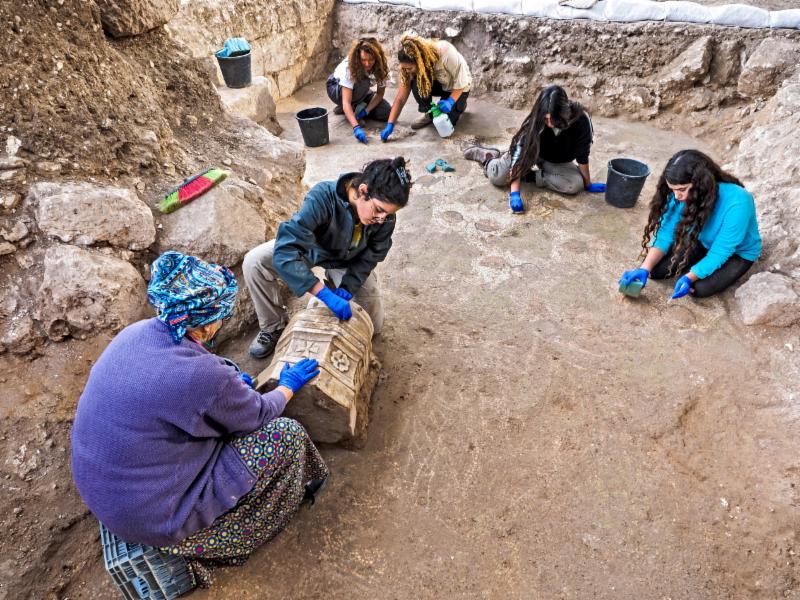
The spectacular remains of a 1,500-year-old (Byzantine Period)
monastery and church decorated with mosaic floors and imported marble
elements are currently being uncovered during large scale excavations
conducted by the Israel Antiquities Authority in Beit Shemesh with the
help of over 1,000 teenagers. The excavation is being conducted prior to
the expansion of Ramat Beit Shemesh, funded by the Ministry of
Construction and Housing, and implemented by the CPM Corporation managed
by Anatoly Snider.
According to Benyamin Storchan, director of the excavations for the
Israel Antiquities Authority, "We were surprised by the wonderful state
of preservation of the ancient remains, and the richness of the finds
being uncovered. The artifacts found in the large building, which seems
to be a monastic compound, may indicate that the site was important and
perhaps a center for ancient pilgrims in the Judean Shephelah region.
During the excavation, we uncovered before our eyes the remains of
walls built of large worked stone masonry and a number of architectural
elements including a marble pillar base decorated with crosses and
marble window screens. The marble artifacts were brought from the region
of Turkey and further inland by wagon. In one of the rooms we uncovered
a beautiful mosaic floor decorated with birds, leafs, and
pomegranates". "We already know of a number of ancient churches and
monasteries in the Judean Shephelah" added Storchan, "but this one has
outstanding preservation".
Until now, only a small percent of the monastery has been uncovered, which was abandoned in the 7th century CE for unknown reasons.
Since the beginning of the excavation during the summer, over 1,000
teenagers from different groups and organization, mostly schools and
pre-military organizations have participated in the excavation.
According to Hadas Keich, 16 years old and student of the Sde Boker
Field School "We searched for a way to fundraise for our class trip to
Poland, and we decided to take part in the archaeological excavations.
Little by little we uncovered here exciting finds, which helped to
connect us to our country and its history. Amazing what is hidden here
beneath our feet."
Photos & Video Credits: Assaf Peretz, Yaniv Berman,
An impressive 2200-year-old (Hellenistic period) structure, possibly an
Idumean palace or temple, was uncovered during Sukkot in archaeological
excavations at the site of Horvat 'Amuda, situated at the heart of a
military training area in the Lachish region.
According to the excavation
directors, Dr. Oren Gutfeld of the Hebrew University, and Pablo Betzer
and Michal Haber of the Israel Antiquities Authority: "If this
was indeed an Idumean palace or temple, it is a rare and exciting find -
similar structures in this country can be counted on the fingers of one
hand. It seems that the building was intentionally dismantled, possibly
during the Hasmonean conquest of the region."
Two stone incense altars were discovered in one of the rooms. One of
them, bearing the carved image of a bull, is depicted as standing in
what is apparently the façade of a temple adorned with magnificent
columns. According to the archaeologists, the altar is "a unique and
rare find in terms of its decoration." The bull, they say, "may have
symbolized a deity worshipped by the Idumeans." In addition to the
incense altar, delicate pottery vessels were also uncovered, including
painted bowls, juglets and oil lamps.
Also found at the site are numerous underground spaces, used as quarries or to house ritual baths (miqvaot),
oil presses and dovecotes. Hiding tunnels from the time of the Jewish
revolts against the Romans were also discovered; one of these contained
an intact cooking pot from the time of the Bar Kokhba Revolt (132-135
CE).
The new discovery came to light with the help of camera-equipped drones
- technology that has become part of the archaeologists' tool box in
recent years. As part of an extensive archaeological research project of
the area between Bet Guvrin and Maresha in the north and Moshav Amatzia
in the south, the drone cameras photographed the archaeological remains
from high above, subsequently revealing hints of the structure now
under excavation.
Calling the discovery a research breakthrough, the
archaeologists say: "This technology helped us choose where to focus our
excavation probes, and, indeed, it very quickly emerged that this was
in fact a unique discovery. We hope that our continued excavation of the
site in the spring will uncover more of the story told here."
The excavation at "Horvat Amuda", which was funded by the Beit Lehi
Foundation and the Israel Antiquities Authority, was carried out with
the participation of archaeology students from the Hebrew University,
Bar-Ilan University, as well as a group of volunteers from the United
States.
During the Hellenistic period "Horvat Amuda" was apparently one of the
agricultural satellite settlements of Maresha, which had by now become
the Idumean district capital (today it is part of Bet Guvrin-Maresha
National Park).
Prior to that, in the fifth century BCE (the Persian
period), the Idumeans - a Semitic people originating in southern Jordan -
settled in the Judean Shephelah (foothills). After the area was
conquered by the Hasmoneans in 112 BCE, the Idumeans converted and
subsequently blended into the Judean population.
Photos Credits: Michal Haber, Clara Amit, Courtesy of the Israel Antiquities Authority
The mosaic, which was apparently the floor of a church or
monastery, contains an inscription noting the year of the building's
construction according to the Georgian calendar * This is the first
Georgian church or monastery ever discovered on the Israeli coast.
An impressive 1,500-year-old church, with an inscription in Greek
mentioning a date according to the Georgian calendar, was uncovered in
archaeological excavations in Ashdod in August. According to the
archaeologists, the floor was part of a Georgian church or monastery.
This is the third season of excavation at the ancient tell of Ashdod-Yam, under the direction of Dr. Alexander Fantalkin of Tel Aviv University's Archaeology and Ancient Near Eastern Civilizations Department, in cooperation with Prof. Angelika Berlejung of Leipzig University. The
colored mosaic came to light during expansion of the excavation at the
Ashdod-Yam antiquities site, in a cooperative project with the
participation of Dr. Fantalkin, Dr. Balbina Bäbler of the University of
Göttingen, and Sa'ar Ganor, Israel Antiquities Authority Ashkelon
district archaeologist.
The ancient city of Ashdod-Yam, on the coast of what is now the
southern part of the city of Ashdod, was one of the most important
cities on the coast of the Land of Israel in the Byzantine period. The
city, known in sources of the period as Azotus Paralios, covered a large
area, and the renowned Madaba Map shows it with public buildings,
including churches and a street flanked by colonnades. Beginning in the
last excavation season, ancient Ashdod-Yam, hidden under the sand dunes,
began to bring forth real surprises, which are shedding light on the
city's long-ago inhabitants.
The dig uncovered a remarkable mosaic, with a four-line commemoration
inscription in Greek dedicated to the structure's builders. The
inscription mentions Bishop Procopius, in whose day the church was
built, and the year of its construction, apparently according to the
Georgian calendar:
"[By the grace of God (or Christ)], this work was done from the
foundation under Procopius, our most saintly and most holy bishop, in
the month Dios of the 3rdindiction, year 292".
According to Dr. Leah Di Segni of the Hebrew University of Jerusalem,
who deciphered the inscription, the date according to the Georgian
calendar corresponds to the year 539 CE. "This is the earliest
appearance of the use of the Georgian calendar in the Land of Israel,
many years before it was used in Georgia itself," Dr. Di Segni said. Dr. Fantalkin, Dr. Bäbler and Ganor said: "As far as we know, Ashdod is now home to the largest community of Jews of Georgian origin in the world.
Testimony to the presence of the actual Georgians in the Land of Israel
as far back as the Byzantine period has been found dozens of kilometers
from Ashdod - in Jerusalem and its surroundings. But this is the first time that a Georgian church or monastery has been discovered on the Israeli coast."
The archaeologists said that according to historical sources, the
famous Georgian prince and bishop Peter the Iberian lived in Ashdod-Yam
before his death. "And now it seems that we have uncovered actual
evidence of his influence on the Byzantine city of Ashdod-Yam," they
added. "This public structure, which has only now begun to come to
light, is part of an extensive archaeological complex in the southern
part of modern Ashdod. We are now hard at work to raise additional funds
to continue the archaeological excavation of Ashdod-Yam," the
excavators said.
Photos Credit: Anat Rasiuk, Courtesy of the Israel Antiquities Authority
The earliest evidence of the arrival of eggplants in this
Israel has come to light in the City of David, the archeological site of
ancient Jerusalem: A 1,100-year-old refuse pit found in Israel
Antiquities Authority excavations in the Jerusalem Walls National Park
reveals dietary habits in the Early Islamic period
When did eggplants first arrive in Israel? A 1,100-year-old refuse pit,
discovered in archaeological excavations at the stepped street in the
City of David in the Jerusalem Walls National Park, may provide an
answer. Eggplant seeds were identified in the pit, which dates from the
Early Islamic period (also called the Abbasid period - 750-940 CE).
These seeds, the earliest evidence of eggplants known in this country,
were found alongside thousands of grape seeds, olive and Christ's
thorn jujube pits, black mulberries, lentils, figs and more. The refuse
pit was uncovered in an Israel Antiquities Authority excavation on the
stepped street in the City of David, in collaboration with the Israel
Nature and Parks Authority and funded by the City of David Foundation. According to Nahshon Szanton, excavation director for
the Israel Antiquities Authority: "As a natural outcome of their
activity, workshops and markets created a great deal of garbage that
sometimes was buried in refuse pits and cesspits that were dug nearby.
Archaeological findings from the refuse pits provide tangible evidence
of what written historical sources of the period have to say, and
provide valuable information about the diet, lifestyle and economic and
trade connections of the inhabitants of Jerusalem and neighboring
countries 1,000 years ago. The eggplant seeds, which originated in Persia, are just one example of the research potential of ancient refuse."
In the refuse pit that was discovered along the Second Temple Period
Pilgrimage Road in the City of David, was discovered various vessels.
Among them was an ancient lamp bearing the inscription "baracha" or
blessing, in Arabic. Also found were bones from cattle, fish and birds,
as well as many types of seeds. These represent a variety of foods and
vegetable products - legumes, fruit and vegetables, as well as edible
wild grasses that were also used as spices and for medicinal purposes.
The contents of the pit are now being studied intensively by Oriya Amichay and Nahshon Szanton
for the Israel Antiquities Authority, in cooperation with Bar-Ilan
University's Archaeo-Botany Laboratory, headed by Prof. Ehud Weiss.
According to the scholarsAmichay andSzanton : "Finding
thousands of grape seeds in refuse pit could attest to industrial
activity involving grapes. Wine may have been produced here, or, more
likely, grape honey (dibes). We know that with the Muslim
conquest grape honey production became more prevalent in the area while
wine production declined due to the Muslim religious ban on alcoholic
beverages."
To the researchers' surprise, eggplant was also discovered among the
many botanical species found in the pit. The discovery of the earliest
eggplant seeds in this country and dating them to the Abbasid period
provides important information about how eggplant first became part of
local agriculture. According to the scholars: "The Arab conquest
increased the extent of commerce in this country in general and in the
Jerusalem area in particular. This gradual process led to changes in the
diet of the local inhabitants due to the arrival of new species and
tastes in our region, in addition to those already familiar in the local
cuisine up to that time."
The scholars note that the botanical finds were uncovered due a rare
mineral phenomenon: "In Israel, organic finds are usually preserved if
they become carbonized as the result of a fire or when the site is in an
area where weather conditions delay the breakdown of the material (for
example in the Judean Desert). In contrast to these types of
preservation, the botanical finds in the refuse pit on the stepped
street in the City of David, like material found in refuse pits
discovered in the past in excavations at the nearby Givati Parking Lot,
were preserved in a unique way: The components of the seeds underwent a
mineral process that rendered them inorganic - their outer form did not
change and the seeds did not decompose, but rather were preserved in the
pit until they were recovered during the excavation.
Photos and Clip Credits:
Photos: Eliyahu Yannai, Clip: Michel Rozilio & Amit Ben Atar
The discovery of more than a thousand sites in Syria has revised our
understanding of the settlement of the steppes during all periods in
the history of the Near East. Recently, analysis of aerial and satellite
images has enabled the discovery of a vast structured surveillance and
communication network dating from the Middle Bronze Age (2nd millennium
BCE). This research, led by researchers from the Archéorient laboratory
(Environnements et sociétés de l'Orient ancien - CNRS/Université Lumière
Lyon 2) and the Directorate-General of Antiquities and Museums of
Syria, is published in the journal Paléorient on December 19, 2017.
The region explored by the Franco-Syrian mission "Marges arides de
Syrie du Nord" is located to the east of Hama and extends across
approximately 7,000 km2. Positioned at the threshold of the densely
populated sedentary regions of the Fertile Crescent to the west, and the
arid, nomad-inhabited steppes to the east, it has not been continuously
exploited by the region's inhabitants. Here, the multidisciplinary team
from the geo-archaeological mission has discovered particularly
well-preserved sites, including a fortified surveillance network over
the territory dating from the second millennium (-2,000 to -1,550). It
is the first time that such an extensive fortified system has been
discovered in the territory.
This structure, exceptional in its extent and designed to protect
urban areas and their hinterlands, is composed of a series of
fortresses, small forts, towers, and enclosures that run along the
mountainous ridge which dominates the steppes of central Syria. The
researchers' work suggests that the fortresses were made from large
blocks on unsculpted basalt and formed walls several meters wide and
high. In addition, each fortified site was positioned in such a way to
ensure that it could see and be seen by others. The spatial organization
of this network thus depended on the ability to communicate through
light (or smoke) signals in order to rapidly convey information to the
major centers of power. The purpose of this regional network would have
been to defend the territory, to surveil and protect transport corridors
and, above all, to protect the most attractive lands.
These results consolidate field observations conducted prior to the
exploration. These had already enabled the sites to be dated using
ceramics collected on site. The access to aerial and satellite
observations, from 1960 to the present day, made it possible to
reconstruct the network beyond the limits of the zone under exploration.
It has thus been identified across a north-south distance of around 150
km.
Six hundred kilometers south of Lake Titicaca and more than 3700 m
above sea level, the Intersalar region, between the two large salt lakes
of Uyuni and Coipasa, is dotted with fields of quinoa and numerous
communities. Today, this region is the main producer of this pseudo
cereal that is exported throughout the world. Close to these villages,
numerous archaeological settlement sites bear witness to an ancient
human occupation, dating from between the 13th and 15th centuries.
Within an area of 60 x 40 km, the researchers studied 48 sites, at which
they identified more than 4500 archaeological granaries that were used
for quinoa storage.
But, was the climate at that time similar to the
current climate? All climate proxies agree and characterize the period
from 1200-1450 CE as dry. Within this drier time interval, the rise of
rainfed agriculture in the southern altiplano coincided with a
catastrophic volcanic event, the eruption of the Samalas Volcano in
Indonesia (1257 CE), that initiated climatic changes lasting several
decades, with drops in temperature and precipitation on a global scale.
"The massive success of agricultural production in such an
unfavorable environment is very surprising," says Richard Joffre
ecologist at the CNRS. "It can only be explained by the development of
very specific and detailed environmental knowledge that aimed to save
water and avoid frost, and by the mastery of a set of agricultural
practices by this pre-Hispanic society. Many micro-terraces are
discernible. We mapped more than 1500 hectares of them. Moreover, very
few traces of irrigation systems have been found. Production here was
based on an unirrigated agricultural system, something remarkable in
these arid conditions."
Moreover, according to Pablo Cruz, an anthropologist with CONICET,
"the distribution of granaries at the sites and the management of
agricultural land all indicate a non-centralized agrarian system. We
found no material signs of the centralization of power or the presence
of a governing elite."
Thierry Winkel, an ecologist with the IRD, points out "that similar
production systems continue to be employed in the indigenous communities
of Bolivia's southern altiplano today, providing quinoa producers
social and productive resilience in the face of current climate and
socio-economic changes..."
Did this particular social and productive organization make it
easier for this society to adapt to the worsening climate recorded at
that time? The authors of this study propose this stimulating
hypothesis. The authors highlight that "these principles of
decentralization and self-organization are proving to be an effective
response in terms of adaptive strategies in the face of environmental
adversity."
IMAGE: Drone aerial shot of the ancient Turkish
ruins on Dongoin shiree. (North at the top.) Segments of the
inscriptions and sarcophagus excavated from the hole at the center of
the...
view more
Credit: Osaka University and Institute of History and Archaeology, Mongolian Academy of Science
A joint excavation team from Osaka University and the Institute of
History and Archaeology of the Mongolian Academy of Sciences discovered
the ruins of a unique monument surrounded by 14 large stone pillars with
Turkic Runic inscriptions arranged in a square on the steppe called
Dongoin shiree in eastern Mongolia during their three-year (2015 ~ 2017)
joint excavation. (Figure 1)
Before the investigation of the ruins began in May 2015,
intellectuals involved had thought that inscriptions and ruins of Turkic
royalties were only on the steppes in the western part of Ulan Bator,
the capital of Mongolia (Figure 2). However, this excavation team led by
Professor Takashi OSAWA at Osaka University discovered 12 new
inscriptions at the site, obtaining clues for clarifying power
relationships in eastern Mongolia in the Middle Ages from the contents
of the inscriptions and the stone configuration at the monument.
The major feature of the monument is its structural configuration in
which the stone sarcophagus at the center of the mound, where a
deceased person might be placed, is surrounded by 14 stone pillars with
inscriptions (Figure 3). On ever stone inscription, tamga (signs) of the
ancient Turkic tribes are carved more than 100. These excavated
inscriptions are some of the largest Turkic inscriptions discovered in
Mongolia. Using radiocarbon dating of pieces of calcined coal,
sheepskin, and horse bone excavated from the sarcophagus, it was
estimated that this unique monument was built in the 8th century, during
the late Second Ancient Turkic Qaghanate.
Professor Takashi OSAWA deciphered these inscriptions and found that
the person who is buried and commemorated in the inscriptions assumed
the position of Yabgu (viceroy), the highest ranking just behind Qaghan*, during the reign of Bilge Qaghan (716-734 AD) of the Second Turkic Qaghanate. It was also found that the Yabgu became a Tölis-Shad
(Royalty of the East), a commander in chief and highest administrative
officer, in eastern Mongolia during the reign of Tengri Qaghan (734-741
AD). * Qaghan (or Khagan) is a title of imperial rank in the Turkic and Mongolian languages equal to the status of emperor, and is someone who rules a Qaghanate or Khaganate (empire).
These findings show that the Dongoin shiree steppe, where the unique
monument ruins remain, was the center of the eastern area of the
ancient Turkic Qaghanate, whose location was not known from materials
written in Chinese and Turkic texts.
This monument will reveal that power relationships of rulers in the
east area of the Turkic Qaghanate and their territories as well as their
political and military relationships with Mongolian tribes, such as the
Khitan, Tatabi, and Tatar. In addition, the arrangement of these stone
pillars on the plateau will also provide important information for
discussing the religious ideas and world outlook of the ancient nomads.
Ancient faeces from prehistoric burials on the Greek island of Kea
have provided the first archaeological evidence for the parasitic worms
described 2,500 years ago in the writings of Hippocrates - the most
influential works of classical medicine.
University of Cambridge researchers Evilena Anastasiou and Piers
Mitchell used microscopy to study soil formed from decomposed faeces
recovered from the surface of pelvic bones of skeletons buried in the
Neolithic (4th millennium BC), Bronze Age (2nd millennium BC) and Roman
periods (146 BC - 330 AD).
The Cambridge team worked on this project with Anastasia
Papathanasiou and Lynne Schepartz, who are experts in the archaeology
and anthropology of ancient Greece, and were based in Athens.
They found that eggs from two species of parasitic worm (helminths)
were present: whipworm (Trichuris trichiura), and roundworm (Ascaris
lumbricoides). Whipworm was present from the Neolithic, and roundworm
from the Bronze Age.
Hippocrates was a medical practitioner from the Greek island of Cos,
who lived in the 5th and 4th centuries BC. He became famous for
developing the concept of humoural theory to explain why people became
ill.
This theory - in which a healthy body has a balance of four
'humours': black bile, yellow bile, blood and phlegm - remained the
accepted explanation for disease followed by doctors in Europe until the
17th century, over 2,000 years later.
Hippocrates and his students described many diseases in their
medical texts, and historians have been trying to work out which
diseases they were. Until now, they had to rely on the original written
descriptions of intestinal worms to estimate which parasites may have
infected the ancient Greeks.
The Hippocratic texts called these
intestinal worms Helmins strongyle, Ascaris, and Helmins plateia.
The researchers say that this new archaeological evidence identifies
beyond doubt some of the species of parasites that infected people in
the region. The findings are published today in the Journal of Archaeological Science: Reports.
"The Helmins strongyle worm in the ancient Greek texts is likely to
have referred to roundworm, as found at Kea. The Ascaris worm described
in the ancient medical texts may well have referred to two parasites,
pinworm and whipworm, with the latter being found at Kea," said study
leader Piers Mitchell, from Cambridge's Department of Archaeology.
"Until now we only had estimates from historians as to what kinds of
parasites were described in the ancient Greek medical texts. Our
research confirms some aspects of what the historians thought, but also
adds new information that the historians did not expect, such as that
whipworm was present".
The mention of infections by these parasites in the Hippocratic
Corpus includes symptoms of vomiting up worms, diarrhoea, fevers and
shivers, heartburn, weakness, and swelling of the abdomen.
Descriptions of treatment for intestinal worms in the Corpus were
mainly through medicines, such as the crushed root of the wild herb
seseli mixed with water and honey taken as a drink.
"Finding the eggs of intestinal parasites as early as the Neolithic
period in Greece is a key advance in our field," said Evilena
Anastasiou, one of the study's authors. "This provides the earliest
evidence for parasitic worms in ancient Greece."
"This research shows how we can bring together archaeology and
history to help us better understand the discoveries of key early
medical practitioners and scientists," added Mitchell.
IMAGE: The fortress of Kuelap, popularly known
as 'the Machu Picchu of the north,' dominates the landscape at an
elevation of 3,000 meters.
view more
Credit: Chiara Barbieri
The Chachapoyas region was conquered by the Inca Empire in the late
15th century. Knowledge of the fate of the local population has been
based largely on Inca oral histories, written down only decades later
after the Spanish conquest. The Inca accounts claim that the native
population was forcibly resettled out of Chachapoyas and dispersed
across the Inca Empire.
However, a new study in Scientific Reports,
by an international team including researchers from the Max Planck
Institute for the Science of Human History, uses genetic evidence to
reveal that despite Inca conquest, the population of Chachapoyas has
remained genetically distinct, and not assimilated with that of the Inca
heartland.
Despite their spectacular achievements, from the first cities of the
Americas to the Inca Empire, the indigenous peoples of the Andes left
no written histories. One legacy that can now be read, however, is the
genetic diversity of their descendants today, especially when taken
together with the rich archaeology of the Andes and the prehistory of
its native languages. This is the approach taken in a new study in Scientific Reports to test the demographic legacy of the Incas.
The study emerges out of a collaboration between research institutes
in Peru and in Germany, including the Max Planck Institute for the
Science of Human History. The focus is on a key region in the
cloud-forest transition between the Andes and Amazonia in northern Peru.
Here the Incas encountered fierce resistance from the "Warriors of the
Clouds," the Chachapoyas culture, noted particularly for its
distinctive body-shaped sarcophagi and the monumental fortress of
Kuelap, the "Machu Picchu of the north."
Particularly to punish and to
secure control over such rebellious lands, the Incas are thought to have
resettled millions of people across the "Four Quarters" of their
empire, Tawantinsuyu.
Chachapoyas was reportedly singled out for such
treatment, making it an ideal case for using genetics to test the
accuracy of Inca oral histories, which were not written down until
almost a century later, by the Spanish conquistadors.
"By targeting various linguistic indicators, we were able to
pinpoint a genetic signal in Chachapoyas that turned out to be far more
diverse than we expected, especially in the male line, from father to
son," explains Chiara Barbieri, a geneticist at the Max Planck Institute
for the Science of Human History in Jena, Germany, and lead author of
the study. "First of all, there's still a strong surviving Native
American component, despite all the admixture with European genes ever
since the Spanish conquest. What's more, here the native component is
quite different from the main genetic network in the highlands of
central and southern Peru. This is where the Inca Empire and its
predecessors originated, and their conquests, road networks and
empire-building ended up homogenizing the genetic make-up here."
The
current study reveals how the people of Chachapoyas, by contrast,
remained relatively isolated. "So it seems that some genetic legacy of
the Chachapoyas did indeed resist Inca impacts, all the way through to
today," explains Barbieri.
Two Peruvian geneticists, José Sandoval and Ricardo Fujita of the
Universidad San Martin de Porres in Lima, Peru, also took part in the
study. "These latest samples are part of a wider genetic coverage of
Peru that we've been building up for years. It's these groups like the
Chachapoya, culturally and linguistically highly distinctive, who have
the most to tell us about our ancestors: where they came from, where
they migrated to, what interactions they had with each other, and so on.
Also, the Chachapoyas culture left such extensive archaeological
remains that there are good prospects for recovering ancient DNA, to
complement the modern picture."
Paul Heggarty, a linguist and senior author of the study, also of
the Max Planck Institute for the Science of Human History, was first
motivated to launch this project after unexpected results from a
linguistic fieldwork trip to Chachapoyas. He was able to find a few
remaining elderly speakers of an indigenous language that most assumed
was already extinct in this region. "Quechua is one of our most direct
living links to the people of the New World before Columbus. It still
has millions of speakers, more than any other language family of the
Americas - but not in Chachapoyas anymore. There are only a dozen or so
fluent speakers now, in a few remote villages, so we need to act fast
if we're to work out its real origins here."
The Chachapoyas form of Quechua has usually been classified as most
closely related to the Quechua spoken in Ecuador, but the new DNA
results show no close connections between the Quechua-speakers in these
two areas. "Linguists need to rethink their traditional view of the
family tree of Quechua languages, and the history of how they spread
through the Andes," notes Heggarty. "It seems that Quechua reached
Chachapoyas without any big movement of people. This also doesn't fit
with the idea that the Incas forced out the Chachapoyas population
wholesale."
Jairo Valqui, another linguist co-author from the National
University of San Marcos in Lima, adds a further perspective on an even
earlier language layer. "Once Quechua and Spanish arrived, the local
Chachapoyas languages died out. Recovering anything from them is a real
puzzle and a challenge for linguists. They left very few traces, but
there are some characteristic combinations of sounds, for example, that
still survive in people's surnames and in local placenames, like Kuelap
itself."
Valqui, himself a Chachapoyano, also makes a point of taking these
genetic results back to the local population. "For Peruvian society
today, this matters. There's long been an appreciation of the Incas, but
often at the cost of sidelining everything else in the archaeological
record across Peru, and the diversity in our linguistic and genetic
heritage too. As these latest findings remind us: Peru is not just Machu
Picchu, and its indigenous people were not just the Incas."
IMAGE: Map of sites and postulated migratory pathways associated with modern humans dispersing across Asia during the Late Pleistocene.
view more
Credit: Bae et al. 2017. On the origin of modern
humans: Asian perspectives. Science. Image by: Katerina Douka and
Michelle O'Reilly
Most people are now familiar with the traditional "Out of Africa"
model: modern humans evolved in Africa and then dispersed across Asia
and reached Australia in a single wave about 60,000 years ago. However,
technological advances in DNA analysis and other fossil identification
techniques, as well as an emphasis on multidisciplinary research, are
revising this story. Recent discoveries show that humans left Africa
multiple times prior to 60,000 years ago, and that they interbred with
other hominins in many locations across Eurasia.
A review of recent research on dispersals by early modern humans
from Africa to Asia by researchers from the Max Planck Institute for the
Science of Human History and the University of Hawai'i at Manoa
confirms that the traditional view of a single dispersal of anatomically
modern humans out of Africa around 60,000 years ago can no longer be
seen as the full story. The analysis, published in the journal Science,
reviews the plethora of new discoveries being reported from Asia over
the past decade, which were made possible by technological advances and
interdisciplinary collaborations, and shows that Homo sapiens reached
distant parts of the Asian continent, as well as Near Oceania, much
earlier than previously thought. Additionally, evidence that modern
humans interbred with other hominins already present in Asia, such as
Neanderthals and Denisovans, complicates the evolutionary history of our
species.
New model: Multiple dispersals of modern humans out of Africa, beginning as early as 120,000 years ago
The authors brought together findings from multiple recent studies
to refine the picture of human dispersals out of Africa and into Asia.
While scientists once thought that humans first left Africa in a single
wave of migration about 60,000 years ago, recent studies have identified
modern human fossils in far reaches of Asia that are potentially much
older. For example, H. sapiens remains have been found at multiple sites
in southern and central China that have been dated to between 70,000
and 120,000 years ago. Additional finds indicate that modern humans
reached Southeast Asia and Australia prior to 60,000 years ago.
However, other recent studies do confirm that all present-day
non-African populations branched off from a single ancestral population
in Africa approximately 60,000 years ago. This could indicate that there
were multiple, smaller dispersals of humans out of Africa beginning as
early as 120,000 years ago, followed by a major dispersal 60,000 years
ago. While the recent dispersal contributed the bulk of the genetic
make-up of present-day non-Africans, the earlier dispersals are still
evident.
"The initial dispersals out of Africa prior to 60,000 years ago were
likely by small groups of foragers, and at least some of these early
dispersals left low-level genetic traces in modern human populations. A
later, major 'Out of Africa' event most likely occurred around 60,000
years ago or thereafter," explains Michael Petraglia of the Max Planck
Institute for the Science of Human History.
Multiple interbreeding events
Recent genetic research has resolved the question of whether or not
modern humans interbred with other ancient hominins - they definitely
did. Modern humans interbred not only with Neanderthals, but also with
our recently-discovered relatives the Denisovans, as well as a currently
unidentified population of pre-modern hominins. One estimate is that
all present-day non-Africans have 1-4% Neanderthal heritage, while
another group has estimated that modern Melanesians have an average of
5% Denisovan heritage. In all, it is now clear that modern humans,
Neanderthals, Denisovans and perhaps other hominin groups likely
overlapped in time and space in Asia, and they certainly had many
instances of interaction.
The increasing evidence of interactions suggests that the spread of
material culture is also more complicated than previously thought.
"Indeed, what we are seeing in the behavioral record is that the spread
of so-called modern human behaviors did not occur in a simple
time-transgressive process from west to east. Rather, ecological
variation needs to be considered in concert with behavioral variation
between the different hominin populations present in Asia during the
Late Pleistocene," explains Christopher Bae of the University of Hawai'i
at Manoa.
In light of these new discoveries, our understanding of human
movements across the Old World has become much more complex, and there
are still many questions left open. The authors argue for the
development of more complicated models of human dispersals and for
conducting new research in the many areas of Asia where none has been
done to date. Additionally, it will be important to review materials
collected prior to the development of modern analytic methods, to see
what more can now be learned from them. "Fortunately," states Katerina
Douka, also of the Max Planck Institute for the Science of Human
History, "there have been an increasing number of multidisciplinary
research programs launched in Asia over the past few decades. The
information that is being reported is helping to fill in the gaps in the
evolutionary records."
"It is an exciting time to be involved with interdisciplinary research projects across Asia," adds Bae.
-
Storytelling promoted co-operation in hunter-gatherers prior to the advent of organised religion, a new UCL study reveals.
The research shows that hunter-gatherer storytellers were
essential in promoting co-operative and egalitarian values before
comparable mechanisms evolved in larger agricultural societies, such as
moralising high-gods.
Storytellers were also more popular than even the best foragers,
had greater reproductive success, and were more likely to be co-operated
with by other members of the camp, according to the research published
today in Nature Communications.
The researchers, led by Daniel Smith, Andrea Migliano and Lucio
Vinicius from UCL's Department of Anthropology and funded by the
Leverhulme Trust, based their findings on their study of the Agta, an
extant hunter-gatherer group descended from the first colonisers of the
Philippines more than 35,000 years ago.
They asked three elders to tell them stories they normally told
their children and each other, resulting in four stories narrated over
three nights. They found the stories about humanised natural entities
such as animals or celestial bodies promoted social and co-operative
norms to co-ordinate group behaviour.
One, about the male sun falling out with the female moon before
settling their differences over who should illuminate the sky by
agreeing to share the duty, one during the day and the other during the
night. The story promotes sex equality and co-operation between the
sexes, which is common among forager societies.
The UCL study showed that 70% of a sample of 89 stories from
seven different hunter-gatherer societies concerned reinforcing and
regulating social behaviour.
"These stories appear to co-ordinate group behaviour and
facilitate co-operation by providing individuals with social information
about the norms, rules and expectations in a given society", according
to Daniel Smith.
Consistent with this interpretation, Agta camps with a greater
proportion of skilled story-tellers possessed increased levels of
co-operation.
Almost 300 members from 18 Agta camps were also asked to choose
who they would most like to live with, with skilled storytellers nearly
twice as likely to be nominated as less skilled individuals.
Potentially because they receive increased social support in
return for telling stories, the study found that skilled storytellers
had on average 0.53 more children than those who were not skilled,
demonstrating the reproductive benefits of being a good storyteller.
The authors state that storytelling may have been pivotal in
organising human social behaviour by promoting co-operation, spreading
co-operative norms and representing punishment of norm-breakers.
"Hunter-gatherer religions do not have moralising gods and yet
they are highly cooperative towards the whole community. Thus,
storytelling in hunter-gatherers was a precursor to more elaborate forms
of narrative fiction such as moralising high-gods, common in
post-agricultural populations", said Andrea Migliano, the last author of
the paper.
New research by a team of scientists and archaeologists based at the
Weizmann Institute of Science and the University of Copenhagen suggests
that the 15,000-year-old 'Natufian Culture' could live comfortably in
the steppe zone of present-day eastern Jordan - this was previously
thought to be either uninhabitable or only sparsely populated.
The hunter-gatherers of the Natufian Culture, which existed in
modern-day Israel, Jordan, Lebanon and Syria between c. 14,500 - 11,500
years ago, were some of the first people to build permanent houses and
tend to edible plants. These innovations were probably crucial for the
subsequent emergence of agriculture during the Neolithic era.
Previous
research had suggested that the centre of this culture was the Mount
Carmel and Galilee region, and that it spread from here to other parts
of the region. The new study by the Copenhagen-Weizmann team, published
in Scientific Reports, challenges this 'core region' theory.
The new paper is based on evidence from a Natufian site located in
Jordan, c. 150 km northeast of Amman. The site, called Shubayqa 1, was
excavated by a University of Copenhagen team led by Dr. Tobias Richter from 2012-2015.
The excavations uncovered a well-preserved Natufian site, which
produced a large assemblage of charred plant remains. These kinds of
botanical remains are rare at many other Natufian sites in the region,
and enabled the Weizmann-Copenhagen team to obtain the largest number of
dates for any Natufian site yet in Israel or Jordan.
"We dated more than twenty samples from different layers of the
site, making it one of the best and most accurately dated Natufian sites
anywhere. The dates show, among other things, that the site was first
settled not long after the earliest dates obtained for northern Israel,
ca. 14,600 years ago. This suggests that the Natufian either expanded
very rapidly, which we think is unlikely, or that it emerged more or
less simultaneously in different parts of the region," Dr. Richter
reports, adding:
"The early date of Shubayqa 1 also shows that Natufian
hunter-gatherers were more versatile than previously thought. Past
research had linked the emergence of the Natufian to the rich habitat of
the Mediterranean woodland zone. But the early dates from Shubayqa show
that these late Pleistocene hunter-gatherers were also able to live
quite comfortably in more open parkland steppe zones further east. Some
of their subsistence appears to have relied heavily on the exploitation
of club rush tubers, as well as other wild plants. They also hunted
birds, gazelle and other animals," says Tobias Richter.
Precise dating methodology
The dating was undertaken by Professor Elisabetta Boaretto at the
Weizmann Institute of Science using Accelerator Mass Spectrometry, or
AMS, dating. Boaretto is head of the D-REAMS lab in the Weizmann
Institute - one of the few labs in the world that works with the
technology and methods to analyze even the smallest organic remains from
a site and precisely date them.
Using a specially designed mass spectrometer, Boaretto is able to
reveal the amount of carbon-14 in a sample down to the single atom.
Based on the half-life of the radioactive carbon-14 atoms, the dating
done in her lab is accurate to around 50 years, plus or minus. For the
analysis of the specimen from Shubayqa, the team was able to select only
short-lived plant species or short-lived plant parts, such as seeds or
twigs, to obtain the dates. This ensured the highest possible accuracy
for the dates.
Boaretto says that the "core area" theory may have come about, in
part, because the Mt. Carmel sites have been the best preserved and
studied, until now. In addition to calling into question the idea of the
Natufian beginning in one settlement and spreading outwards, the study
suggests that the hunter-gatherers who lived 12,000 to 15,000 years ago
were ingenious and resourceful. They learned to make use of numerous
plants and animals where ever they were, and to tend them in a way that
led to early settlement.
The authors say that this supports a view in which there were many
pathways to agriculture and "the 'Neolithic way of life' was a highly
variable and complex process that cannot be explained on the basis of
single-cause models."
You may already be surprised to hear there are iron objects dating
back to the Bronze Age, but their meteorite origin is even more
astonishing. Though meteorites had already been recognized as one source
of this metal, the scientific community couldn't determine whether they
accounted for most or simply a few Bronze Age iron artifacts. Albert
Jambon, as part of his work at the Institut de minéralogie, de physique
des matériaux et de cosmochimie (CNRS / UPMC / IRD / Muséum national
d'Histoire naturelle),[1] has demonstrated that iron used during the
Bronze Age is always meteoric and he explained how this practice was
abandoned during the Iron Age. His work is published in the December
2017 issue of the Journal of Archaeological Science.
The Iron Age began in Anatolia and the Caucasus around 1200 BCE. But
nearly 2,000 years earlier, various cultures were already fashioning
objects out of iron. These items were extremely rare and always greatly
treasured. Iron ore abounds on the Earth's surface. So what made these
artifacts so valuable? Initial research had shown that some were made
with iron from meteorites, which led scientists to wonder how many
others were. Albert Jambon gathered the available data and conducted his
own nondestructive chemical analyses of samples using a portable X-ray
fluorescence spectrometer.
His collection of iron artifacts includes
beads from Gerzeh (Egypt, ?3200 BCE); a dagger from Alaca Höyük (Turkey,
?2500 BCE); a pendant from Umm el-Marra (Syria, ?2300 BCE); an axe from
Ugarit (Syria, ?1400 BCE) and several others from the Shang dynasty
civilization (China, ?1400 BCE); and the dagger, bracelet, and headrest
of Tutankhamen (Egypt, ?1350 BCE).
His analyses revealed that each of these Bronze Age artifacts was
made with meteoric iron. When large celestial bodies like our planet are
forming, nearly all nickel drifts towards the molten iron core. Thus,
it is extremely rare to find nickel on the surface. However, some
meteorites are created when celestial bodies are shattered. If these
meteorites are composed of core material, they mostly contain iron with
high levels of nickel and cobalt. This characteristic makes it possible
to identify the source of iron.
Meteoric iron is also already in a metal
state, ready for use, which explains why it went into all Bronze Age
iron artifacts. In contrast, the iron compounds in terrestrial ores must
first undergo the process of reduction, which removes bound oxygen to
yield the desired metal. This is the basis of smelting in furnaces, a
breakthrough that marked the beginning of the Iron Age. With smelting,
Iron Age cultures could forget rare extraterrestrial metal and tap into
terrestrial iron ores, which were far more abundant and easier to
procure. Albert Jambon's findings refute certain theories proposing that
nickel-laden iron alloys were obtained from terrestrial ores.
IMAGE: This is bone jewelry found at Sungir in the burial of children (1-3) and in the cultural layer (4).
view more
Credit: Vladislav Zhitenev
Vladislav Zhitenev, a Russian archaeologist from MSU, studied bone
jewelry found at Sungir Upper Paleolithic site. A group led by Vladislav
Zhitenev found out that many items were crafted specifically for burial
purposes, while others were worn on a daily basis. The style of the
jewelry was influenced by many cultures of Europe and the Russian Plain.
The article was published in EPAUL 147.
Sungir Upper Paleolithic site is located in Vladimir Region and is
dated back to 29,000-31,000 years. Scientist began to study his place
over thirty years ago. The encampment of prehistoric hunters includes a
burial site of a 40-50 year old man and a grave of two children who died
10-14 years of age. Archaeological excavation revealed over 80 thousand
different objects
.
"This children's grave contains more adornments and other burial
items than any other Upper Paleolithic burial site in Eurasia," - says
Vladislav Zhitenev, the author of the study, doctor of historical
sciences, and assistant professor of the Archaeology Department of the
Faculty of History, MSU. Currently all findings are kept in the State
Vladimir-Suzdal Museum Reserve.
Having studied pendants made from the teeth of Arctic fox, bone
beads, and other personal ornaments, scientists found out that these
items were worn for a long time as they exhibited rubbing marks and
other signs of tear. Other ornaments found at the burials were made in a
hurry and don't look so smooth and convenient. Evidently, they were
crafted specifically for the burial ceremony. These items include a
large horse figurine with a disproportionately short back led. Although
the surface of the figurine had been polished, it has a lot of
manufacturing and processing marks.
It is still unknown why the grave of children appeared to contain so
many objects including worn ones. According to one version, people used
the child burial to make a sacrifice to save the community from an
adversity of some kind, such as illness or hunger. Burial items were
made not only by experienced craftsmen, but by children as well. One of
the tusk disks found in the children's grave was made carelessly and
unskillfully. It is likely it was crafted by a kid.
Adornments are elements of a non-verbal language used by prehistoric
people to tell friends from enemies and to learn about one's social
status and standing. By studying personal ornaments scientists learn
more about different aspects of intercultural communication in the Upper
Paleolithic period.
Vladislav Zhitenev found out that the man and the children lived
relatively at the same time separated by several generations at most.
This is confirmed by the identical style of peronal ornaments found in
their graves. The children were buried at the same time, but the time
period between their death and the passing of the man is still unknown.
Radiocarbon dating method failed to provide an answer as it is not
accurate to the year when applied to such prehistoric specimens. But
when radiocarbon dating gives only approximate results, archaeologists
turn to implicit data.
"When looking at an item, one can always see a master's hand. Many
adornments from the burial sites of the man and the children were
crafted in the same way, as if by the same person. Alternatively, this
technique could have been passed within the family, say, from father to
son or from grandmother to granddaughter," - explains Vladislav
Zhitenev. Therefore, the man and the children were separated in time by
no more than several dozen years.
Sungir adornments are difficult to classify and include into a
certain cultural tradition, as they had been influenced by many
cultures. On the one hand, they have a lot in common with the
Aurignacian culture that was widely spread in Western and Central Europe
in the Early Upper Paleolithic Stone Age. On the other hand, Sungir
findings resemble those from some early sites in Kostenki. Finally, all
these items are combined with stone objects crafted using a Neanderthal
technology, although the remains found in Sungir belonged to Homo
sapiens.
Having studied Sungir adornments, scientists found out that a part
of them was crafted specifically for the burial ceremony, and another
one was worn on a daily basis; the man and the children lived roughly at
the same time; and the crafting style was influenced by many cultures
including the Aurignacian culture and the culture of the Russian Plain.
In his further studies Vladislav Zhitenev plans to focus on
intercultural communication, for example, to find difference between the
sites with and without a Neanderthal component.
IMAGE: A piece of the Coptic translation of the First Apocalypse of James from the Nag Hammadi Codex V.
view more
Credit: Image of artifact from the Nag Hammadi Library, Oxford University.
The first-known original Greek copy of a heretical
Christian writing describing Jesus' secret teachings to his brother
James has been discovered at Oxford University by biblical scholars at
The University of Texas at Austin.
To date, only a small number of texts from the Nag Hammadi library
-- a collection of 13 Coptic Gnostic books discovered in 1945 in Upper
Egypt -- have been found in Greek, their original language of
composition. But earlier this year, UT Austin religious studies scholars
Geoffrey Smith and Brent Landau added to the list with their discovery
of several fifth- or sixth-century Greek fragments of the First
Apocalypse of James, which was thought to have been preserved only in
its Coptic translations until now.
"To say that we were excited once we realized what we'd found is an
understatement," said Smith, an assistant professor of religious
studies. "We never suspected that Greek fragments of the First
Apocalypse of James survived from antiquity. But there they were, right
in front of us."
The ancient narrative describes the secret teachings of Jesus to his
brother James, in which Jesus reveals information about the heavenly
realm and future events, including James' inevitable death.
"The text supplements the biblical account of Jesus' life and
ministry by allowing us access to conversations that purportedly took
place between Jesus and his brother, James -- secret teachings that
allowed James to be a good teacher after Jesus' death," Smith said.
Such apocryphal writings, Smith said, would have fallen outside the
canonical boundaries set by Athanasius, Bishop of Alexandria, in his
"Easter letter of 367" that defined the 27-book New Testament: "No one
may add to them, and nothing may be taken away from them."
With its neat, uniform handwriting and words separated into
syllables, the original manuscript was probably a teacher's model used
to help students learn to read and write, Smith and Landau said.
"The scribe has divided most of the text into syllables by using
mid-dots. Such divisions are very uncommon in ancient manuscripts, but
they do show up frequently in manuscripts that were used in educational
contexts," said Landau, a lecturer in the UT Austin Department of
Religious Studies.
The teacher who produced this manuscript must have "had a particular
affinity for the text," Landau said. It does not appear to be a brief
excerpt from the text, as was common in school exercises, but rather a
complete copy of this forbidden ancient writing.
Smith and Landau announced the discovery at the Society of Biblical
Literature Annual Meeting in Boston in November and are working to
publish their preliminary findings in the Greco Roman Memoirs series of
the Oxyrhynchus Papyri.
IMAGE: This is the Ebbsfleet excavation with Pegwell Bay & Ramsgate.
view more
Credit: University of Leicester
The first evidence for Julius Caesar's invasion of Britain has been
discovered by archaeologists from the University of Leicester. The
findings will be explored as part of the BBC Four's Digging For Britain
on Wednesday 29 November.
Based on new evidence, the team suggests that the first landing of
Julius Caesar's fleet in Britain took place in 54BC at Pegwell Bay on
the Isle of Thanet, the north--east point of Kent.
This location matches Caesar's own account of his landing in 54 BC,
with three clues about the topography of the landing site being
consistent with him having landed in Pegwell Bay: its visibility from
the sea, the existence of a large open bay, and the presence of higher
ground nearby.
The project has involved surveys of hillforts that may have been
attacked by Caesar, studies in museums of objects that may have been
made or buried at the time of the invasions, such as coin hoards, and
excavations in Kent.
The University of Leicester project, which is funded by the
Leverhulme Trust, was prompted by the discovery of a large defensive
ditch in archaeological excavations before a new road was built. The
shape of the ditch at Ebbsfleet, a hamlet in Thanet, is very similar to
some of the Roman defences at Alésia in France, where the decisive
battle in the Gallic War took place in 52 BC.
The site, at Ebbsfleet, on the Isle of Thanet in north-east Kent
overlooking Pegwell Bay, is now 900 m inland but at the time of Caesar's
invasions it was closer to the coast. The ditch is 4-5 metres wide and 2
metres deep and is dated by pottery and radiocarbon dates to the 1st
century BC.
The size, shape, date of the defences at Ebbsfleet and the presence
of iron weapons including a Roman pilum (javelin) all suggest that the
site at Ebbsfleet was once a Roman base of 1st century BC date.
The archaeological team suggest the site may be up to 20 hectares in
size and it is thought that the main purpose of the fort was to protect
the ships of Caesar's fleet that had been drawn up on to the nearby
beach.
Dr Andrew Fitzpatrick, Research Associate from the University of
Leicester's School of Archaeology and Ancient History said: "The site at
Ebbsfleet lies on a peninsular that projects from the south-eastern
tip of the Isle of Thanet. Thanet has never been considered as a
possible landing site before because it was separated from the mainland
until the Middle Ages.
"However, it is not known how big the Channel that separated it from
the mainland (the Wantsum Channel) was. The Wantsum Channel was clearly
not a significant barrier to people of Thanet during the Iron Age and
it certainly would not have been a major challenge to the engineering
capabilities of the Roman army."
Caesar's own account of his landing in 54 BC is consistent with the landing site identified by the team.
Dr Fitzpatrick explained: "Sailing from somewhere between Boulogne
and Calais, Caesar says that at sunrise they saw Britain far away on the
left hand side. As they set sail opposite the cliffs of Dover, Caesar
can only be describing the white chalk cliffs around Ramsgate which were
being illuminated by the rising sun.
"Caesar describes how the ships were left at anchor at an even and
open shore and how they were damaged by a great storm. This description
is consistent with Pegwell Bay, which today is the largest bay on the
east Kent coast and is open and flat. The bay is big enough for the
whole Roman army to have landed in the single day that Caesar describes.
The 800 ships, even if they landed in waves, would still have needed a
landing front 1-2 km wide.
"Caesar also describes how the Britons had assembled to oppose the
landing but, taken aback by the size of the fleet, they concealed
themselves on the higher ground. This is consistent with the higher
ground of the Isle of Thanet around Ramsgate.
"These three clues about the topography of the landing site; the
presence of cliffs, the existence of a large open bay, and the presence
of higher ground nearby, are consistent with the 54 BC landing having
been in Pegwell Bay."
The last full study of Caesar's invasions was published over 100 years ago, in 1907.
It has long been believed that because Caesar returned to France the
invasions were failures and that because the Romans did not leave a
force of occupation the invasions had little or no lasting effects on
the peoples of Briton. It has also been believed that because the
campaigns were short they will have left few, if any, archaeological
remains.
The team challenge this notion by suggesting that in Rome the
invasions were seen as a great triumph. The fact that Caesar had crossed
the sea and gone beyond the known world caused a sensation. At this
time victory was achieved by defeating the enemy in battle, not by
occupying their lands.
They also suggest that Caesar's impact in Briton had long-standing
effects which were seen almost 100 years later during Claudius's
invasion of Briton.
Professor Colin Haselgrove, the principal investigator for the
project from the University of Leicester, explained: "It seems likely
that the treaties set up by Caesar formed the basis for alliances
between Rome and British royal families. This eventually resulted in the
leading rulers of south-east England becoming client kings of Rome.
Almost 100 years after Caesar, in AD 43 the emperor Claudius invaded
Britain. The conquest of south-east England seems to have been rapid,
probably because the kings in this region were already allied to Rome.
"This was the beginning of the permanent Roman occupation of
Britain, which included Wales and some of Scotland, and lasted for
almost 400 years, suggesting that Claudius later exploited Caesar's
legacy."
The fieldwork for the project has been carried out by volunteers
organised by the Community Archaeologist of Kent County Council who
worked in partnership with the University of Leicester. The project was
also supported by staff from the University of Leicester Archaeological
Services (ULAS).
Kent County Council cabinet member Matthew Balfour said: "The
council is delighted to have been able to work in partnership with the
University of Leicester to help build on the incredible findings made
during our road development. The archaeology of Thanet is very special
and we are particularly pleased that such important findings have been
made with the involvement of volunteers from the Kent community. When we
built the road we ensured that the community played a big part in the
archaeological works and it is satisfying to see the legacy of our
original work continuing."
Principal Archaeological Officer for Kent County Council Simon
Mason, who oversaw the original road excavations carried out by Oxford
Wessex Archaeology, said: "Many people do not realise just how rich the
archaeology of the Isle of Thanet is. Being so close to the continent,
Thanet was the gateway to new ideas, people, trade and invasion from
earliest times. This has resulted in a vast and unique buried
archaeological landscape with many important discoveries being regularly
made. The peoples of Thanet were once witness to some of the earliest
and most important events in the nation's history: the Claudian invasion
to start the period of Roman rule, the arrival of St Augustine's
mission to bring Christianity and the arrival of the Saxons celebrated
through the tradition of Hengist and Horsa. It has been fantastic to be
part of a project that is helping to bring another fantastic chapter,
that of Caesar, to Thanet's story."
Andrew Mayfield said: "The project has been a fantastic opportunity
for us to explore the extraordinary archaeology of Thanet alongside the
University of Leicester team. Volunteers, both locally from Thanet and
further afield in Kent, enthusiastically give up their time and the
success of the dig is very much down to their hard work and commitment.
We were also lucky to welcome students from both Canterbury
Universities, a local branch of the Young Archaeologists Club as well as
the local school. This was very much a team effort."
The findings will be explored further as part of the BBC Four's
Digging For Britain. The East episode, in which the Ebbsfleet site
appears, will be the second programme in the series, and will be
broadcast on Wednesday 29 November 2017.
Comparisons of bone strength between prehistoric women and living
female athletes demonstrate that prehistoric women performed rigorous
manual labor for thousands of years in central Europe at levels
exceeding those of modern women. Additionally, in contrast to men,
manual labor was a more important component of prehistoric women's
behavior than terrestrial mobility through the first 5,500 years of
European farming, suggesting women's labor was crucial to the
development of agriculture.
Past studies of the rigidity of male
shinbones (tibia bones) during the same period demonstrate how male
terrestrial mobility likely increased over time. Meanwhile, women's
activity in prehistory has been difficult to interpret, due in part to a
wide variability in their bone changes, potential for sex-specific
skeletal responses and a lack of modern comparative data.
To address
these issues, Alison Macintosh and colleagues investigated trends in
female upper and lower limb bones and inter-limb strength. They compared
the bones of prehistoric women spanning the first ~6,150 years of
agriculture in central Europe to living female semi-elite athletes -
endurance runners, rowers and soccer players - and sedentary women.
Inter-limb strength proportions between the humerus and tibia were used
to characterize the relative importance of manual labor (indicated by
more force on the arms) versus terrestrial mobility (indicated by more
force on the legs) among agricultural women.
A new study comparing the bones of Central European women that lived
during the first 6,000 years of farming with those of modern athletes
has shown that the average prehistoric agricultural woman had stronger
upper arms than living female rowing champions.
Researchers from the University of Cambridge's Department of
Archaeology say this physical prowess was likely obtained through
tilling soil and harvesting crops by hand, as well as the grinding of
grain for as much as five hours a day to make flour.
Until now, bioarchaeological investigations of past behaviour have
interpreted women's bones solely through direct comparison to those of
men. However, male bones respond to strain in a more visibly dramatic
way than female bones.
The Cambridge scientists say this has resulted in the systematic
underestimation of the nature and scale of the physical demands borne by
women in prehistory.
"This is the first study to actually compare prehistoric female
bones to those of living women," said Dr Alison Macintosh, lead author
of the study published today in the journal Science Advances.
"By interpreting women's bones in a female-specific context we can
start to see how intensive, variable and laborious their behaviours
were, hinting at a hidden history of women's work over thousands of
years."
The study, part of the European Research Council-funded ADaPt (Adaption, Dispersals and Phenotype) Project, used a small CT scanner in Cambridge's PAVE laboratory
to analyse the arm (humerus) and leg (tibia) bones of living women who
engage in a range of physical activity: from runners, rowers and
footballers to those with more sedentary lifestyles.
The bones strengths of modern women were compared to those of women
from early Neolithic agricultural eras through to farming communities of
the Middle Ages.
"It can be easy to forget that bone is a living tissue, one that
responds to the rigours we put our bodies through. Physical impact and
muscle activity both put strain on bone, called loading. The bone reacts
by changing in shape, curvature, thickness and density over time to
accommodate repeated strain," said Macintosh.
"By analysing the bone characteristics of living people whose
regular physical exertion is known, and comparing them to the
characteristics of ancient bones, we can start to interpret the kinds of
labour our ancestors were performing in prehistory."
Over three weeks during trial season, Macintosh scanned the limb
bones of the Open- and Lightweight squads of the Cambridge University
Women's Boat Club, who ended up winning this year's Boat Race and
breaking the course record. These women, most in their early twenties,
were training twice a day and rowing an average of 120km a week at the
time.
The Neolithic women analysed in the study (from 7400-7000 years ago)
had similar leg bone strength to modern rowers, but their arm bones
were 11-16% stronger for their size than the rowers, and almost 30%
stronger than typical Cambridge students.
The loading of the upper limbs was even more dominant in the study's
Bronze Age women (from 4300-3500 years ago), who had 9-13% stronger arm
bones than the rowers but 12% weaker leg bones.
A possible explanation for this fierce arm strength is the grinding
of grain. "We can't say specifically what behaviours were causing the
bone loading we found. However, a major activity in early agriculture
was converting grain into flour, and this was likely performed by
women," said Macintosh.
"For millennia, grain would have been ground by hand between two
large stones called a saddle quern. In the few remaining societies that
still use saddle querns, women grind grain for up to five hours a day.
"The repetitive arm action of grinding these stones together for
hours may have loaded women's arm bones in a similar way to the
laborious back-and-forth motion of rowing."
However, Macintosh suspects that women's labour was hardly likely to have been limited to this one behaviour.
"Prior to the invention of the plough, subsistence farming involved
manually planting, tilling and harvesting all crops," said Macintosh.
"Women were also likely to have been fetching food and water for
domestic livestock, processing milk and meat, and converting hides and
wool into textiles.
"The variation in bone loading found in prehistoric women suggests
that a wide range of behaviours were occurring during early agriculture.
In fact, we believe it may be the wide variety of women's work that in
part makes it so difficult to identify signatures of any one specific
behaviour from their bones."
Dr Jay Stock, senior study author and head of the ADaPt Project,
added: "Our findings suggest that for thousands of years, the rigorous
manual labour of women was a crucial driver of early farming economies.
The research demonstrates what we can learn about the human past through
better understanding of human variation today."
The formation and vast influence of China’s landmark Qin dynasty will be showcased at the Cincinnati Art Museum in Terracotta Army: Legacy of the First Emperor of China from April 20 through August 12, 2018.
This special exhibition includes 120 objects drawn from the
collections of Chinese art museums and archaeological institutes. More
than 40 of these works have never been on view in the U.S. before this
exhibition.
Expanding upon previous exhibitions, Terracotta Army not
only includes the impressive terracotta figures, but also considers
important works of art from the Qin's neighboring states and tells the
story of the nomadic peoples of northwestern China.
Dating from 770-206 B.C., these works of art, excavated from the
emperor’s mausoleum as well as aristocratic and nomadic tombs, richly
reflect history, myths and burial practices in ancient China. In
addition to the nine life-size terracotta figures, the exhibition
includes a cavalry horse, arms and armor, ritual bronze vessels, works
in gold and silver, jade ornaments, precious jewelry and ceramics.
“This international exchange is a momentous occasion for our museum
and the Greater Cincinnati region. The original scholarship supporting
the exhibition and the opportunity for Cincinnati to learn about the
legacy of the First Emperor will be a revelation to every visitor to the
museum. We are proud to showcase the splendor of the art and history of
China through our ambitious partnership with Shaanxi Province,” said
Cameron Kitchin, Cincinnati Art Museum’s Louis and Louise Dieterle
Nippert Director.
The Cincinnati Art Museum co-organized the exhibition with the
Virginia Museum of Fine Arts (VMFA), where it makes its debut from
November 18, 2017 to March 11, 2018. The exhibition is presented in
partnership with Shaanxi Provincial Cultural Relics Bureau, Shaanxi
History Museum (Shaanxi Cultural Heritage Promotion Center), and Emperor
Qin Shihuang’s Mausoleum Site Museum of the People’s Republic of China.
Dr. Hou-mei Sung, Curator of Asian Art at the Cincinnati Art Museum,
curated the exhibition with Li Jian, the VMFA’s E. Rhodes and Leona B.
Carpenter Curator of East Asian Art.
Terracotta Army’s story begins with Ying Zheng (259-210
B.C.), who became the first emperor of China in 221 B.C., after his army
defeated other regional states and unified the country. After coming to
power, he implemented fundamental cultural, political and economic
reforms and established China’s core territory.
In 1974 local farmers digging a well outside the city of Xi’an in
Shaanxi province, China, discovered pottery shards and bronze arrows
near the mausoleum of Ying Zheng. This led to the astonishing discovery
of 8,000 life-size terracotta warriors and horses, which is considered
one of the most important archaeological finds in human history. The
mausoleum was named a UNESCO World Heritage Site in 1987.
Significantly, the exhibition considers the relationship between the
first emperor’s Qin dynasty (221-206 B.C.) and other peoples, exploring
their distinctive artistic styles and fostering an appreciation of
diverse cultures. The exhibition also provides a glimpse into ongoing
excavations and research, which continue to shed new light on the Qin
culture and the First Emperor’s burial complex.
“I believe this exhibition will provide a great opportunity for
American audiences to understand the daily life of Qin people and the
visual culture of the empire more than 2,000 years ago. This exhibition
actively promotes cultural exchange between China and the United States,
and increases understanding and friendship between peoples of both
nations,” said Dr. Zhao Rong, Director of the Shaanxi Provincial
Cultural Relics Bureau.
A major scholarly catalogue titled Terracotta Army: Legacy of the First Emperor of China
accompanies the exhibition. It includes contributions from the curators
and other scholars and features new scholarship and research based on
recent excavations.
The exhibition will be on view in the Western & Southern
Galleries (232 and 233). Organized with the generous support of the
Harold C. Schott Foundation. It is presented by CFM International, and
supported by the John and Dorothy Hermanies Fund, the E. Rhodes and
Leona B. Carpenter Foundation, Christie’s, Elizabeth Tu Hoffman
Huddleston, and the Jeanann Gray Dunlap Foundation.
Tickets for Terracotta Army: Legacy of the First Emperor of China
are free for museum members and are available for purchase by the
general public at the Cincinnati Art Museum front desk and online at
cincinnatiartmuseum.org.
The exhibition includes an interactive activity, family and gallery
guides and related programs will be held at the museum throughout the
spring and summer. The Art After Dark on Friday, April 27, 5–9 p.m.,
will be themed by the exhibition and will include free admission to the
exhibition. Other events include Family First Saturday: Explore China on
May 2, 2017, 12–4 p.m., and the Fourth Annual Cincinnati Asian Art
Society Lecture, which will focus on the terracotta army on May 6, 2018,
at 2 p.m. Find more information at cincinnatiartmuseum.org/terracotta.
The Cincinnati Art Museum is supported by the
generosity of individuals and businesses that give annually to Artswave.
The Ohio Arts Council helps fund the Cincinnati Art Museum with state
tax dollars to encourage economic growth, educational excellence and
cultural enrichment for all Ohioans. The Cincinnati Art Museum
gratefully acknowledges operating support from the City of Cincinnati,
as well as our members.
Free general admission to the Cincinnati Art Museum is made possible
by a gift from the Rosenthal Family Foundation. Special exhibition
pricing may vary. Parking at the Cincinnati Art Museum is free. The
museum is open Tuesday – Sunday, 11 a.m.–5 p.m. and Thursday, 11 a.m.–8
p.m.
An ancient image of a two-humped camel has been discovered in the
Kapova cave (Southern Urals). The age of the painting is preliminarily
estimated to be between 14,500 and 37,700 years, a time when there were
no camels in the Southern Urals. This discovery confirms researchers'
belief that artists in the Upper Paleolithic could migrate over long
distances.
The image of a camel's shape is painted in red ochre and partially
outlined with charcoal. This unique discovery was made by Eudald
Guillamet, a well-known restorative specialist from Andorra, who was
invited by the State Office of Protection of Cultural Heritage of
Bashkiria to clean the cave of graffiti.
"This painting, cleared on the polychrome panel "Horses and Signs,"
which has been well-known since the late 1970s, has no analogues in the
art complexes of the caves of France and Spain, but does have some
resemblance to the camel painting from the Ignatievskaya cave. Now it
will probably become a significant image in the Upper Paleolithic cave
bestiary of the Southern Urals," comments V.S. Zhitenev, head of Moscow
State University's South Ural archeological expedition and leading
researcher for the Kapova and Ignatievskaya caves.
"The age of the drawings in this panel cannot be accurately
established yet, but the results of uranium-thorium dating of the
calcite deposits on which the image is painted, and which cover it,
unambiguously show that the time period during which the drawing was
made was during the Upper Paleolithic age, which is no earlier than
37,700 years ago and no later than 14,500 years ago. In the course of
excavating the Kapova cave, only the upper layer of deposits with traces
of activity of Paleolithic artists, about 17,000 - 19,000 years ago,
has been dated so far," concluded the scientist.
The artistic features and arrangement of the images, as well as the
traces of human activity in the cave, show that the traditions of
organization of underground sanctuaries in the Upper Paleolithic
originated in the Franco-Cantabrian region. However, at such a distance
from the main European cluster of cave sites with wall paintings, local
specifics in the development of graphic traditions inevitably arose.
The long evolution of the traditions of cave art in the region is
revealed by the fact that people living in the Southern Urals during the
Ice Age painted not only the images of horses, bisons, mammoths, and
woolly rhinoceroses that were widespread in European caves, but
representations of the local fauna as well. Analysis of stone tools
confirms the assumption.
"It is very significant that this camel vividly confirms the theory
of the Volga-Caspian direction of the connections among the people who
created the sanctuary in the Kapova cave. This direction was earlier
grounded in the use of ornaments from fossil shells brought from the
Caspian region. Moreover, this direction is very interesting in terms of
a possible way that the traditions of creating cave sanctuaries with
wall paintings could have been spread, if we consider the Carpathian
caves with Ice Age wall paintings," explains Vladislav Zhitenev.
"Equally important, along with the discovery of the camel painting, is
the fact that fragments of the shape of another animal, apparently a
mammoth, were cleaned off. This is the first well-preserved painting of a
woolly giant from the Ice Age on the middle level of the cave. Cleaning
calcite off from the newly-discovered figures confirmed the theory of a
significant similarity in the general structure of the visual panels,
with leading images of horses, and large geometric shapes, in which one
may see representations of animals. The similarity in the arrangement of
vertical and horizontal figures (or rather, explicit compositions) on
panels located on two different floors indicates a profound connection
between the ideas expressed by the Paleolithic artists. The upper and
middle levels are connected by a thirteen meter high vertical well."
In December, archeologists from Moscow State University will
continue researching Paleolithic art in the Kapova and Ignatievskaya
caves. In winter, the walls of the underground halls and galleries are
much drier than in the summer, which makes it easier to reveal the
smallest details of the paintings. Monitoring of the state of the wall
paintings will also continue, with the aim of studying the impact of
dynamic factors of the underground environment on geochemical processes
related to the destruction of wall paintings. It is carried out in a
joint project with specialists from Shulgan-Tash Nature Reserve.
Kapova cave
The Kapova cave is located in Bashkiria, 400 km away from Ufa, on
the territory of Shulgan-Tash nature reserve. The cave is one of the
most famous sites containing Paleolithic parietal art in Europe. Among
the images depicted, one can come across such vivid representatives of
mammoth fauna as wooly rhino, bison, horse, and, of course, the wooly
mammoth itself. The wall paintings were created about 17 000 - 19 000
years ago. Figures of fish and a zooanthropomorhic figure (a mixomorph
combining human and animal traits), rarely seen in European sites, are
of special interest.
The principal array of images in the Kapova cave are unidentifiable
spots of red pigment, which are partially blurred shapes, partly the
remains of erased drawings, and partially traces of Paleolithic artistic
activities of unknown origin. Some of the found traces of artistic
activity are finger-painted lines, fingerprints and, possibly, prints of
the lower part of the palm. The microstratigraphic position of the
remains of intentionally erased images, above which the Paleolithic
artist painted new animal shape and signs, has been revealed in some
panels.