Monday, December 31, 2012
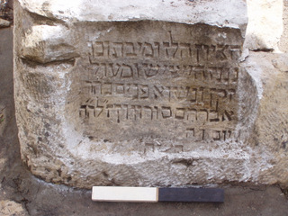
Christians and Jews In 5th-6th Century Yemen
Complete article
...In 525 AD, the Negus, or king, of Aksum dispatched a fleet across the Red Sea. Soldiers and fighting elephants were ferried across the water to the East on un-tarred, raft-like ships to spread the gospel. In the ensuing decades, his army captured large parts of Arabia.
The first spearhead was targeted at the capital Zafar. Like a fortress in the sky, the town was perched on an extinct volcano, at an altitude of 2,800 meters (9,184 feet) above sea level. Its walls, riddled with towers and alarm bells, were four-and-a-half kilometers long. About 25,000 people lived in Zafar.
According to Yule, between the 3rd and the 5th century the confederation managed to complete a "meteoric rise" and become a superpower. Its merchants traded in sandalwood from Ceylon and valerian from Persia. The state controlled the port of Aden, where the ships of spice traders from India docked. Frankincense, which was made in Arabia, was also traded. It was a place of luxury. Yule found wine amphorae, the remains of precious fish condiments and palaces decorated with sphinxes and lions.
A Peaceful Multi-Cultural Community
The social structure in Zafar also appeared to be unique. The city had a large Jewish community, as evidenced by a seal with a Torah niche. Hebrew inscriptions were discovered. Zafar's residents also included Christians, who built a church there in 354 AD. Arabs who worshipped old idols lived in the alleys.
But this peaceful, multicultural community soon came to an end, as tensions began to mount in the 5th century, and Arabia was transformed into a front.
The Byzantine Empire, bristling with weapons, operated in the west, and its vassals kept making inroads toward the desert. They were accompanied by Christian missionaries, who brought the doctrine of the Holy Trinity to the shepherds on the edge of the Rub' al Khali, the sand desert that makes up much of the southern third of the Arabian Peninsula.
These Sacred Heart imperialists confronted the Persian realm of the Sassanids, with its archers and armies of bearded soldiers clad in heavy metal armor. The Jews, who lived by the tens of thousands in the oases, were to some extent aligned with this power.
It was a confrontation between east and west, and everyone was forced to choose a side.
This also applied to Zafar. To stop the advance of Christianity, individual Arab kings initially converted to Judaism. The entire ruling class of the realm eventually followed suit. From then on, people were given names like Yehuda and Yussuf.
Then they took up arms. In approximately 520 AD, they attacked the Christian colony of Najran, where there were churches and monasteries. Countless Christians were slaughtered. The shocking news traveled all the way to Europe...
Religious practices and rituals in the early days of the Kingdom of Judah has recently been discovered
Rare evidence of the religious practices and rituals in the early days of the Kingdom of Judah including a ritual building (a temple) and a cache of sacred vessels some 2,750 years old have been uncovered at Tel Motza, to the west of Jerusalem.
General view of the excavation site. Photograph: Skyview, courtesy of the Israel Antiquities Authority.
The finds, dated to the early monarchic period and including pottery figurines of men and horses, provide rare testimony of a ritual cult in the Jerusalem region at the beginning of the period of the monarchy.
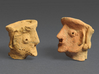
Figurines of a person. Photograph: Clara Amit, courtesy of the Israel Antiquities Authority
They were uncovered during excavations by the Israel Antiquities Authority, prior to work by the National Roads Company on the new Highway 1 section.
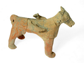
Figurine of a horse. Photograph: Clara Amit, courtesy of the Israel Antiquities Authority
According to Anna Eirikh, Dr. Hamoudi Khalaily and Shua Kisilevitz, directors of the excavation on behalf of the Israel Antiquities Authority, "The ritual building at Tel Motza is an unusual and striking find, in light of the fact that there are hardly any remains of ritual buildings of the period in Judaea at the time of the First Temple. The uniqueness of the structure is even more remarkable because of the vicinity of the site's proximity to the capital city of Jerusalem, which acted as the Kingdom's main sacred center at the time." According to the archaeologists, "Among other finds, the site has yielded pottery figurines of men, one of them bearded, whose significance is still unknown."
Tel Motza and the surrounding region are renowned for their prime archaeological importance. Many finds have previously been uncovered at the site, from a variety of different periods. From the 1990's to the beginning of the present millennium, the site was excavated in preparation for the new route taken by Highway 1. At the time, the site's archaeologists proposed once more identifying the site with the Biblical settlement "Mozah" mentioned in the Book of Joshua – a town in the tribal lands of Benjamin bordering on Judaea (Joshua 18: 26). The proposal was based, among other things, on the discovery at the site of a public building, a large structure with storehouses, and a considerable number of silos. At the time, archaeologists identified the site as a storehouse, run by high-ranking officials, for Jerusalem's grain supplies.
The current excavations have revealed evidence that provides another aspect to our understanding of the site. According to archaeologists Eirikh, Dr. Khalaily and, Kisilevitz, "The current excavation has revealed part of a large structure, from the early days of the monarchic period (Iron Age IIA). The walls of the structure are massive, and it includes a wide, east-facing entrance, conforming to the tradition of temple construction in the ancient Near East: the rays of the sun rising in the east would have illuminated the object placed inside the temple first, symbolizing the divine presence within. A square structure which was probably an altar was exposed in the temple courtyard, and the cache of sacred vessels was found near the structure. The assemblage includes ritual pottery vessels, with fragments of chalices (bowls on a high base which were used in sacred rituals), decorated ritual pedestals, and a number of pottery figurines of two kinds: the first, small heads in human form (anthropomorphic) with a flat headdress and curling hair; the second, figurines of animals (zoomorphic) – mainly of harnessed animals. The archeologists stress that "The find of the sacred structure together with the accompanying cache of sacred vessels, and especially the significant coastal influence evident in the anthropomorphic figurines, still require extensive research."
Ritual elements in the Kingdom of Judah are recorded in archaeological research, especially from the numerous finds of pottery figurines and other sacred objects found at many sites in Israel, and these are usually attributed to domestic rituals. However, the remains of ritual platforms and temples used for ritual ceremonies have only been found at a few sites of this period. According to the site's directors, "The finds recently discovered at Tel Motza provide rare archaeological evidence for the existence of temples and ritual enclosures in the Kingdom of Judah in general, and in the Jerusalem region in particular, prior to the religious reforms throughout the kingdom at the end of the monarchic period (at the time of Hezekiah and Isaiah), which abolished all ritual sites, concentrating ritual practices solely at the Temple in Jerusalem."
Wednesday, December 19, 2012
The Dead Sea Scrolls now available online
On the occasion of the 65th anniversary of the discovery of the Dead Sea Scrolls, the Israel Antiquities Authority and Google has launched the Leon Levy Dead Sea Scrolls Digital Library website, www.deadseascrolls.org.il. The public is invited to experience, view, examine, and explore this collection of over 5000 images of Dead Sea Scrolls, in a quality never seen before.
The library was assembled over the course of two years, in collaboration with Google, using advanced technology first developed by NASA. It includes some 1000 new images of scroll fragments; 3500 scans of negatives from the 1950s; a database documenting about 900 manuscripts, two-thousand years old, comprising thousands of scroll fragments; and interactive content pages. It enables scholars and millions of users worldwide to reveal and decipher details hence invisible to the naked eye. The site displays infra-red and color images at a resolution of 1215 dpi, at a 1:1 scale, equivalent in quality to the original scrolls. Google has provided hosting services and use of Google Maps, image technology and YouTube. The project was made possible by an exceptionally generous grant from the Leon Levy Foundation, and further contribution by the Arcadia Fund, as well as the support of the Yad Hanadiv Foundation.
One of the earliest known texts is a copy of the Book of Deuteronomy, which includes the Ten Commandments; part of chapter 1 of the Book of Genesis, dated to the first century BCE, which describes the creation of the world; a number of copies of Psalms scrolls; tiny texts of tefillin from the Second Temple period; letters and documents hidden by refugees fleeing the Roman army during the Bar Kochba Revolt; and hundreds of additional 2000-year-old texts, shedding light on biblical studies, the history of Judaism and the origins of Christianity.
Shuka Dorfman, Director of the Israel Antiquities Authority, said: "Only five conservators worldwide are authorized to handle the Dead Sea Scrolls. Now, everyone can "touch" the scrolls on-screen around the globe, and view them in spectacular quality, equivalent to the original! On the occasion of the 65th anniversary of their discovery, the IAA, in collaboration with Google, presents the scrolls online, using the most advanced imaging technology. Thus, this most important national treasure is available to the general public, preserving it for future generations."
Yossi Matias, Head of Google’s R&D Center in Israel, said: “We’re working to bring important cultural and historical materials online and help preserve them for future generations. The pieces of culture and history being made accessible today - the manuscripts of the 10 commandments, the story of the creation of the world, and more - are known to almost every schoolchild around the world. This partnership is another step towards preserving cultural material around the world, and enabling users to enjoy it.”
About the Scrolls: In 1947, while searching for a stray goat in the Judean Desert, a Bedouin shepherd came upon a cave, in which he found a clay jar containing 2000-year-old scrolls. Ultimately, Bedouin treasure hunters and archaeologists found the remains of hundreds of additional ancient scrolls in nearby caves. These ancient pieces of parchment and papyrus, including the oldest copies of the Hebrew Bible, were preserved for two-thousand years by the hot, dry desert climate and the darkness of the caves where they were hidden. The scrolls unveil the diverse religious beliefs which prevailed in ancient Judaism during the turbulent Second Temple period, whence Jesus lived and preached. The scrolls are considered the most important archaeological discovery of the twentieth century.
Tuesday, December 18, 2012
Archaeologist finds crisis in Syria has Mesopotamian precedent
Research carried out at the University of Sheffield has revealed intriguing parallels between modern day and Bronze-Age Syria as the Mesopotamian region underwent urban decline, government collapse, and drought.
Dr Ellery Frahm from the University of Sheffield’s Department of Archaeology made the discoveries by studying stone tools of obsidian, razor-sharp volcanic glass, crafted in the region about 4,200 years ago.
Dr Frahm used artefacts unearthed from the archaeological site of Tell Mozan, known as Urkesh in antiquity, to trace what happened to trade and social networks when Bronze-Age Syrian cities were abandoned in the wake of a regional government collapse and increasing drought due to climate shifts.
“Unfortunately,” explained Dr Frahm, “the situation four thousand years ago has striking similarities to today. Much like the fall of the Akkadian Empire, a governmental collapse is a real possibility in Syria after nearly two years of fighting. Some archaeologists and historians contend that the Akkadian Empire was brought down by militarism and that violence ended its central economic role in the region.
“Additionally, farming in north-eastern Syria today relies principally on rainfall rather than irrigation, just as in the Bronze Age, and climate change has already stressed farming there. But it isn't just climate change that is the problem. Farming, rather than herding, has been encouraged at unsustainable levels by the state through land-use policies, and as occurred during urbanisation four millennia ago, populations have dramatically increased in the area.”
The diverse origins of the obsidian tools, which date from the rise of the Akkadian Empire in Mesopotamia to several centuries after its fall, revealed how social networks and trading routes evolved during this period.
Dr Frahm explained the motivation behind the research: “This time of transition in Mesopotamia has received great attention for the concurrence of aridification, de-urbanisation, and the decline of the Akkadian Empire about 4,200 years ago. However, our current understanding of this ‘crisis’ has been almost exclusively shaped by ceramic styles, estimated sizes of archaeological sites, and evidence of changing farming practices. Trade and the associated social networks have been largely neglected in prior studies about this time, and we decided obsidian was an ideal way to investigate them.”
Obsidian blade
Obsidian, naturally occurring volcanic glass, is smooth, hard, and far sharper than a surgical scalpel when fractured, making it a highly desired raw material for crafting stone tools for most of human history. In fact, obsidian tools continued to be used throughout the ancient Middle East for millennia beyond the introduction of metals, and obsidian blades are still used today as scalpels in specialised medical procedures.
“Our discovery that obsidian in Urkesh came from six different volcanoes before the crisis, whereas they normally came from just two or three at surrounding sites, implies that Urkesh was an unusually cosmopolitan city with diverse visitors, or visitors with diverse itineraries. During the crisis, however, obsidian only came from two nearby sources, suggesting that certain trade or social networks collapsed. It was two or three centuries before diverse obsidian appeared again at this city, and even then, it came from different quarries, signalling the impact the crisis had on trade and mobility throughout the wider region.
“One compelling interpretation of our findings is that the regional government of the Akkadian Empire shaped Urkesh’s local economy. This city might have specialised its economy in response to demand from the Akkadians for certain commodities, such as metals from the nearby mountains. With climate shifts and the end of the empire, Urkesh’s inhabitants might have had to refocus their economy on local production and consumption, covering their own needs rather than engaging in specialised long-distance trade.
“By drawing these parallels to the current situation in Syria, we are not making light of it,” explains Dr Frahm. “Quite the opposite. The situation in Syria is heartbreaking, horrifying even when I see the images from Syria via social media. As an archaeologist, there is nothing that I can do to help the situation right now. But those of us who study people and the past are in a unique position to consider what could happen after the immediate crisis ends. What happens to cities when a state falls? How do the residents sustain themselves if that infrastructure collapses? Will they move to another area? Droughts are known to increase wars. As climate change increases, could fighting start again over scarce water resources? This is the type of contribution that archaeology can make towards improving the future.”
Dr Frahm’s team used a variety of scientific techniques to analyse the obsidian artefacts, including an electron microscope outfitted for chemical analyses, a handheld chemical analyser that can be used at archaeological sites, and a series of sophisticated magnetic analyses at one of the world’s best facilities for studying rock magnetism, the Institute for Rock Magnetism at the University of Minnesota.
The paper, entitled Environment and Collapse: Eastern Anatolian Obsidians at Urkesh (Tell Mozan, Syria) and the Third-Millennium Mesopotamian Urban Crisis, has been published online by the Journal of Archaeological Science and is available here: Journal of Archaeological Science
Ohio: Hopewell Civilzation's Pipes From Illinois?
In the early 1900s, an archaeologist, William Mills, dug up a treasure-trove of carved stone pipes that had been buried almost 2,000 years earlier. Mills was the first to dig the Native American site, called Tremper Mound, in southern Ohio. And when he inspected the pipes, he made a reasonable – but untested – assumption. The pipes looked as if they had been carved from local stone, and so he said they were. That assumption, first published in 1916, has been repeated in scientific publications to this day. But according to a new analysis, Mills was wrong.
Illinois State Archaeological Survey director Thomas Emerson and his colleagues discovered that pipestone pipes buried roughly 2,100 years ago in a mound site in southeast Ohio came from stone gathered in northern Illinois. | Photo by L. Brian Stauffer
Illinois State Archaeological Survey director Thomas Emerson and his colleagues discovered that pipestone pipes buried roughly 2,100 years ago in a mound site in southeast Ohio came from stone gathered in northern Illinois. | Photo by L. Brian Stauffer
In a new study, the first to actually test the stone pipes and pipestone from quarries across the upper Midwest, researchers conclude that those who buried the pipes in Tremper Mound got most of their pipestone – and perhaps even the finished, carved pipes – from Illinois.
The researchers spent nearly a decade on the new research. They first collected the mineralogical signatures of stone found in traditional pipestone quarries in Illinois, Kansas, Michigan, Minnesota, Missouri and Ohio. Then they compared the material found in those quarries to the mineralogical makeup of the artifacts left behind by the people of Tremper Mound.
Less than 20 percent of the 111 Tremper Mound pipes they tested were made from local Ohio stone. About 65 percent were carved from flint clay found only in northern Illinois and 18 percent were made of a stone called catlinite – from Minnesota.
The researchers are still puzzling over how most of these materials made it to Ohio from Illinois, and are baffled by another new discovery. Pipes from a site only about 40 miles north of Tremper Mound, an elaborate cluster of immense mounds known as Mound City, were carved almost entirely from local stone. Mound City was inhabited at about the same time or shortly after Tremper Mound, and the pipes found there are stylistically very similar to the Tremper pipes. (See a slideshow of some pipes.)
The researchers describe their findings in a paper in American Antiquity.
These results should remind archaeologists that things are not as simple as they sometimes appear, said Thomas Emerson, the principal investigator on the study and the director of the Illinois State Archaeological Survey (ISAS) at the University of Illinois.
“This is how mythology becomes encased in science,” he said.
The study also confirms that the people who produced these pipestone artifacts, known today as members of the Hopewell tradition, were more diverse and varied in their cultural practices than scientists once appreciated, Emerson said.
The Hopewell people, who lived in the region from about 100 B.C. to roughly A.D. 400, have long been the subject of speculation, as the artifacts they left behind and the manner in which these goods were disposed of are not easily understood. Those living in southeastern Ohio, especially, seemed to be “conspicuous consumers and connoisseurs of the exotic,” Emerson said.
The Hopewell people from that area collected “massive assemblages of obsidian from Wyoming, mica from the Appalachians, and caches of elaborately carved pipes,” Emerson said. They also collected shells from the Gulf Coast, along with the skulls of exotic animals (an alligator, for instance).
“Strange animals, strange minerals, strange things were really a focus,” he said.
Most of the carved stone pipes from that era have been found in Ohio, where very large caches often containing more than 100 pipes were ritually broken, burned and buried, Emerson said. The same style of pipes are found in Illinois, but many fewer have been uncovered in Illinois to date, he said, and they are dispersed, not heaped together in giant hordes as in Ohio. (Watch a video about the Hopewell pipes.
There is evidence of stone carving at the Illinois sources where the stone was gathered, but none at Tremper Mound, suggesting that the Illinois stone was carved into pipes before it was transported to Ohio.
The team used a variety of techniques to analyze the material in the quarries and the artifacts. One method, called X-ray diffraction (XRD), produces a distinct signal that reflects the proportion of minerals in different types of stone. The stone must be pulverized, however, to subject it to XRD. To analyze the intact pipes, the researchers used a non-destructive portable technology, called PIMA, which illuminates a specimen with short-wavelength infrared radiation and records the refracted (unabsorbed) wavelengths, allowing investigators to identify the minerals present. They verified the accuracy of the PIMA by comparing its results to those obtained with XRD on quarry specimens and broken pipes.
The new findings should challenge archaeologists to look more carefully at the evidence left behind by the Hopewell people, Emerson said.
“This study really says to the archaeological community, you need to go back to the drawing board,” he said. “You’ve been telling stories for decades that are based on essentially misinformation.”
Farm from the period of the Hasmonean dynasty founded by the Maccabees
...Archaeologists have announced their discovery of an agricultural farm in Jerusalem's Kiryat Hayovel neighborhood that dates from the period of the Hasmonean dynasty founded by the Maccabees.
The farm was discovered on Hantke Street, during construction work for a light rail line in the area.
The findings indicate two distinct stages of use, one from the Hellenistic period, between 400 B.C.E. and 200 B.C.E., and one from the Roman period, between the middle of the second century B.C.E. and the middle of the first century B.C.E., which corresponds to the time of Hasmonean rule.
There are indications that with more excavation, the farm could turn out to be part of a town, said Israel Antiquities Authority archaeologist Daniel Ein Mor, who is leading the Hantke Street dig.
"We discovered rock foundations in the buildings, pointing to a huge investment," he said. "The quality of the construction is excellent, so I wouldn't be surprised if future findings reveal it is even something bigger, maybe a settlement."
So far archaeologists have uncovered a wine press, outdoor stoves, canals and a large amount of earthenware, including a small perfume bottle, in the area. They also found a small lead weight with a carved letter, possibly the Hebrew letter "yod," which in this case was written upside down.
Ein Mor said he thinks the inhabitants cultivated the land near the Ein Karem Stream, where ancient terraced fields have been discovered...
Complete article
Wednesday, December 12, 2012
Chemical analysis reveals first cheese making in Northern Europe in the 6th millennium BC
The first unequivocal evidence that humans in prehistoric Northern Europe made cheese more than 7,000 years ago is described in research by an international team of scientists, led by the University of Bristol, UK, published today in Nature.
By analysing fatty acids extracted from unglazed pottery pierced with small holes excavated from archaeological sites in Poland, the researchers showed that dairy products were processed in these ceramic vessels. Furthermore, the typology of the sieves, close in shape to modern cheese-strainers, provides compelling evidence that these specialised vessels have been used for cheese-making.
Before this study, milk residues had been detected in early sites in Northwestern Anatolia (8,000 years ago) and in Libya (nearly 7,000 years ago). Nevertheless, it had been impossible to detect if the milk was processed to cheese products.
Researchers from the Organic Geochemistry Unit at the University of Bristol, together with colleagues at Princeton (USA), Łódź, Gdánsk and Poznań (Poland) studied unglazed pottery from the region of Kuyavia (Poland) dating from around 7,000 years ago. These had been typologically interpreted as cheese-strainers by archaeologists for more than 30 years due to the peculiar presence of small sized holes on the surface of the sherds. In fact, these archaeological sherds looked like modern cheese-strainers.
Using lipid biomarker and stable isotope analysis, researchers examined preserved fatty acids trapped in the fabric of the pottery and showed that the sieves had indeed been used for processing dairy products. Milk residues were also detected in non-perforated bowls, which may have been used with the sieves.
Contrastingly, the analyses of non-perforated pottery (cooking pots or bottles) demonstrated that they were not used for processing milk. The presence of ruminant carcass fats in cooking pots showed that they were likely used to cook meat, while the presence of beeswax in bottles suggests the sealing of the pottery to store water.
Thus, the analyses of such a range of ceramics from the same area showed for the first time that different types of pottery were used in a specific manner, with sieves (and maybe bowls) being used for cheese-making, cooking pots for cooking meat and waterproofed bottles for storing water.
The processing of milk and particularly the production of cheese were critical in early agricultural societies as it allowed the preservation of milk in a non-perishable and transportable form and, of primary importance, it made milk a more digestible commodity for early prehistoric farmers.
Mélanie Salque, a PhD student from the University of Bristol and one of the authors of the paper said: "Before this study, it was not clear that cattle were used for their milk in Northern Europe around 7,000 years ago. However, the presence of the sieves in the ceramic assemblage of the sites was thought to be a proof that milk and even cheese was produced at these sites. Of course, these sieves could have been used for straining all sorts of things, such as curds from whey, meat from stock or honeycombs from honey. We decided to test the cheese-making hypothesis by analysing the lipids trapped into the ceramic fabric of the sieves.
"The presence of milk residues in sieves (which look like modern cheese-strainers) constitutes the earliest direct evidence for cheese-making. So far, early evidence for cheese-making were mostly iconographic, that is to say murals showing milk processing, which dates to several millennia later than the cheese strainers."
Peter Bogucki one of the co-authors of this new study and proponent of the cheese strainer hypothesis nearly 30 years ago notes that: "As well as showing that humans were making cheese 7,000 years ago, these results provide evidence of the consumption of low-lactose content milk products in Prehistory. Making cheese allowed them to reduce the lactose content of milk, and we know that at that time, most of the humans were not tolerant to lactose. Making cheese is a particularly efficient way to exploit the nutritional benefits of milk, without becoming ill because of the lactose."
Friday, December 7, 2012
Extensive New First Temple Period Remains Unearthed in Jerusalem
Findings include what could be the largest haul yet of pottery fragments from the time of Jerusalem's First Temple.
Archaeologists, students and volunteers have unearthed archaeological remains that will shed additional light on the occupation of ancient Jerusalem's royal precinct of the time of the Israelite and Judahite kings, going back to the 10th century BCE.
Under the direction of Eilat Mazar of the Hebrew University in Jerusalem, painstaking excavation by a team of archaeologists, including a group from the Herbert W. Armstrong College in the U.S., has revealed extensive architectural elements, including floor layers and walls, that suggest at least one very large structure of yet-to-be-determined function. This, after weeks of excavating through layers containing artifacts, architectural elements and other features representing later periods of occupation, including those of the Byzantine and Second Temple (Herodian) periods.
"Now", says Mazar, "all over the place we have Iron Age (1300 - 600 BCE ) floor layers, we have alot of Iron Age pottery, 10th century BCE pottery......I think it's the richest assemblage we have ever had from the 10th century until now in Jerusalem."
Like the other structures within the vicinity, a building of possible monumental proportions may be emerging. As she stood above looking down at the excavation area spread out below her, she speaks to a small group of observers standing next to her, sharing her vantage point. "We have these large walls that show that this was a very large structure -- it's huge..."
Complete article
Thursday, December 6, 2012
European Romani exodus began 1,500 years ago, DNA evidence shows
Despite their modern-day diversity of language, lifestyle, and religion, Europe's widespread Romani population shares a common, if complex, past. It all began in northwestern India about 1,500 years ago, according to a study reported on December 6th in Current Biology, a Cell Press publication, that offers the first genome-wide perspective on Romani origins and demographic history.
The Romani represent the largest minority group in Europe, consisting of approximately 11 million people. That means the size of the Romani population rivals that of several European countries, including Greece, Portugal, and Belgium.
"We were interested in exploring the population history of European Romani because they constitute an important fraction of the European population, but their marginalized situation in many countries also seems to have affected their visibility in scientific studies," said David Comas of the Institut de Biologia Evolutiva at Universitat Pompeu Fabra in Spain.
The Romani people lack written historical records on their origins and dispersal. To fill in the gaps in the new study, Comas and Manfred Kayser from Erasmus University Rotterdam in the Netherlands, together with their international European colleagues, gathered genome-wide data from 13 Romani groups collected across Europe to confirm an Indian origin for European Romani, consistent with earlier linguistic studies.
The genome-wide evidence specified the geographic origin toward the north or northwestern parts of India and provided a date of origin of about 1,500 years ago. While the Middle East and Caucasus regions are known to have had an important influence on Romani language, the researchers saw limited evidence for shared genetic ancestry between the European Romani and those who live in those regions of the world today. Once in Europe, Romani people began settling in various locations, likely spreading across Europe via the Balkan region about 900 years ago.
"From a genome-wide perspective, Romani people share a common and unique history that consists of two elements: the roots in northwestern India and the admixture with non-Romani Europeans accumulating with different magnitudes during the out-of-India migration across Europe," Kayser said. "Our study clearly illustrates that understanding the Romani's genetic legacy is necessary to complete the genetic characterization of Europeans as a whole, with implications for various fields, from human evolution to the health sciences."
Friday, November 30, 2012
Native Americans and Northern Europeans more closely related than previously thought
Using genetic analyses, scientists have discovered that Northern European populations—including British, Scandinavians, French, and some Eastern Europeans—descend from a mixture of two very different ancestral populations, and one of these populations is related to Native Americans. This discovery helps fill gaps in scientific understanding of both Native American and Northern European ancestry, while providing an explanation for some genetic similarities among what would otherwise seem to be very divergent groups. This research was published in the November 2012 issue of the Genetics Society of America's journal GENETICS (http://www.genetics.org).
According to Nick Patterson, first author of the report, "There is a genetic link between the paleolithic population of Europe and modern Native Americans. The evidence is that the population that crossed the Bering Strait from Siberia into the Americas more than 15,000 years ago was likely related to the ancient population of Europe."
To make this discovery, Patterson worked with Harvard Medical School Professor of Genetics David Reich and other colleagues to study DNA diversity, and found that one of these ancestral populations was the first farming population of Europe, whose DNA lives on today in relatively unmixed form in Sardinians and the people of the Basque Country, and in at least the Druze population in the Middle East. The other ancestral population is likely to have been the initial hunter-gathering population of Europe. These two populations were very different when they met. Today the hunter-gathering ancestral population of Europe appears to have its closest affinity to people in far Northeastern Siberia and Native Americans.
The statistical tools for analyzing population mixture were developed by Patterson and presented in a systematic way in the report. These tools are the same ones used in previous discoveries showing that Indian populations are admixed between two highly diverged ancestral populations and showing that Neanderthals contributed one to four percent of the ancestry of present-day Europeans. In addition, the paper releases a major new dataset that characterizes genetic diversity in 934 samples from 53 diverse worldwide populations.
"The human genome holds numerous secrets. Not only does it unlock important clues to cure human disease, it also reveal clues to our prehistoric past," said Mark Johnston, Editor-in-Chief of the journal GENETICS. "This relationship between humans separated by the Atlantic Ocean reveals surprising features of the migration patterns of our ancestors, and reinforces the truth that all humans are closely related."
Wednesday, November 28, 2012
Archaeologists discover shipwrecks, ancient harbor on coast of Israel
A team of archaeologists from the University of Rhode Island, the Israel Antiquities Authority, and the University of Louisville have discovered the remains of a fleet of early-19th century ships and ancient harbor structures from the Hellenistic period (third to first century B.C.) at the city of Akko, one of the major ancient ports of the eastern Mediterranean. The findings shed light on a period of history that is little known and point to how and where additional remains may be found.

The discoveries were presented on November 15 and 17 in Chicago at the annual meeting of the American Schools of Oriental Research by URI assistant professors Bridget Buxton and William Krieger on behalf of the Israel Coast Exploration project.
According to Buxton, three of the four well-preserved shipwrecks found off the coast south of Akko were first detected using a sub-bottom profiler in 2011. Later, storms stripped off several meters of inshore sediments and temporarily revealed the wrecks, as well as an additional large vessel. The wrecks are now reburied.
During the brief time the shipwrecks were exposed, the Israel Antiquities Authority investigated one of them: a 32 meter vessel which still preserved its brass gudgeon (rudder socket) and many small artifacts, such as plates, a candlestick, and even a cooking pot with bones in it. Laboratory analyses completed this summer by the IAA revealed that the ship's wood came from Turkey. The team believes these ships may have belonged to the Egyptian navy under Admiral Osman Nurredin Bey, whose ships were severely damaged in his attempt to capture Akko in the Egyptian-Ottoman War of 1831. The town eventually fell to Egyptian land forces under Ibrahim Pasha in 1832.
"These ships have occasionally been exposed and buried again by storms since we found them," Buxton said. "We're in a race against time to find other ships in the area and learn from them before storms totally dislodge or destroy them."
Although shipwrecks from the 1800s are not the highest priorities in a region where civilization goes back thousands of years, Buxton is excited by the discovery for what it tells her about where much older ships may be found.
"Like many underwater archaeologists I'm very interested in finding a well-preserved example of an ancient multi-decked warship from the Hellenistic age," said Buxton. "These ships were incredible pieces of technology, but we don't know much about their design because no hulls have been found. However, a combination of unusual environmental and historical factors leads us to believe we have a chance of finding the remains of one of these ships off the northern coast of Israel."
Buxton believes that the ships they are looking for are likely buried in the coastal sediment, which has built up over the centuries through natural processes. However, time is not on their side. "That protective silt is now being stripped away," she said. "And it's being stripped away a lot faster than it was originally dumped, by a combination of development, environmental changes, and the effects of the Aswan Dam." The Nile River has historically deposited large quantities of silt in the area, but the dam has significantly reduced the flow of silt.
The archaeologists found the ships and another early modern vessel within Akko's modern harbor while testing their equipment in preparation for an ongoing survey out in deeper water. The sub-bottom profiler detects anomalies below the sea floor. "It's the gift that keeps on giving," Buxton said. "We found so many targets to explore that we didn't have time to check all of them, but even just having information about where things are helps Koby (Jacob Sharvit, director of the IAA Maritime Antiquities Unit) know where to look after any big storms."
One line of buried targets detected off the southern seawall of old Akko is particularly suggestive. Continuing excavations in this area over the summer revealed an alignment between these targets and a newly-discovered slipway and shipshed structure, which continued out under the sea floor 25 meters from the Ottoman city wall. The feature resembles other naval shipsheds found in places such as Athens where they were used to haul up ancient warships. The excavation project was initially undertaken to strengthen the eroding sea wall, but it also revealed Hellenistic masonry, pottery vessels, an ancient mooring stone, and a stone quay 1.3 meters below the modern sea level. The possibility that much more of the Hellenistic port lies well-preserved under the sea floor is exciting for the archaeologists, because it means that shipwrecks from earlier centuries that have so far not been found at Akko may simply be buried deeper down in the sediment.
"We've got fragmentary historic records for this area in the Hellenistic period, and now we've found a very important feature from the ancient harbor. Ancient shipwrecks are another piece of the puzzle that will help us to rewrite the story of this region at a critical time in Mediterranean history," she said.
Located on the northern coast of Israel, the UNESCO World Heritage Site of Akko is one of the few cities in the Mediterranean with more than 5,000 years of maritime history. Also known as Acre, Ake and Ptolemais, its port was an important waypoint for the Phoenicians, Romans, Crusaders, Ottomans and other ancient maritime empires. In the Hellenistic period, it was bitterly fought over by the rival empires of Egypt and Syria.
"Understanding the history and archaeology of Akko's port is crucial to understanding the broader issues of maritime connectivity and the great power struggles that defined the history of the Eastern Mediterranean during the Hellenistic Age," Buxton said.
Thursday, November 15, 2012
Archaeologists Date Stone-tipped Weapons: 500,000 Years Old

This is a ~500,000-year-old point from Kathu Pan 1. Multiple lines of evidence indicate that points from Kathu Pan 1 were used as hafted spear tips. Scale bar = 1 cm.
A collaborative study involving researchers at Arizona State University, the University of Toronto, and the University of Cape Town found that human ancestors were making stone-tipped weapons 500,000 years ago at the South African archaeological site of Kathu Pan 1 – 200,000 years earlier than previously thought. This study, "Evidence for Early Hafted Hunting Technology," is published in the November 16 issue of the journal Science.
Attaching stone points to spears (known as "hafting") was an important advance in hunting weaponry for early humans. Hafted tools require more effort and foreplanning to manufacture, but a sharp stone point on the end of a spear can increase its killing power.
"There is a reason that modern bow-hunters tip their arrows with razor-sharp edges. These cutting tips are extremely lethal when compared to the effects from a sharpened stick. Early humans learned this fact earlier than previously thought," said Benjamin Schoville, a coauthor of this study affiliated with the Institute of Human Origins, a research center of the College of Liberal Arts and Sciences at Arizona State University
Hafted spear tips are common in Stone Age archaeological sites after 300,000 years ago. This study shows that hafted spear tips were also used in the early Middle Pleistocene, a period associated with Homo heidelbergensis, the last common ancestor of Neandertals and modern humans.
"Rather than being invented twice, or by one group learning from the other, stone-tipped spear technology was in place much earlier," said Schoville. "Although both Neandertals and humans used stone-tipped spears, this is the first evidence that this technology originated prior to or near the divergence of these two species."
"It now looks like some of the traits that we associate with modern humans and our nearest relatives can be traced further back in our lineage," said Jayne Wilkins, lead author from the University of Toronto. "This changes the way we think about early human adaptations and capacities before the origin of our own species."
Point function was determined by comparing wear on the ancient points to damage inflicted on modern experimental points used to spear a springbok carcass target with a calibrated crossbow. This method has been used effectively to study weaponry from more recent contexts in the Middle East and southern Africa.
"When points are used as spear tips, there is a lot of damage that forms at the tip of the point, and large distinctive fractures form. The damage on these ancient stone spear points is remarkably similar to those produced with our calibrated crossbow experiment, and we demonstrate they are not easily created from other processes," said coauthor Kyle Brown, a skilled stone tool replicator from the University of Cape Town.
The points were recovered during 1979 excavations by Peter Beaumont of the McGregor Museum, Kimberly, South Africa.
In 2010, a team directed by coauthor Michael Chazan from the University of Toronto reported that the point-bearing deposits at KP1 dated to around 500,000 years ago using optically stimulated luminescence and U-series/electron spin resonance methods. The dating analyses were carried out by Naomi Porat, Geological Survey of Israel, and Rainer Grün, Australian National University.
Tuesday, November 13, 2012
Desecrated Ancient Temple Sheds Light on Early Power Struggles at Tel Beth-Shemesh

TAU archaeologists unearth unique 11th-century BCE sacred compound with a turbulent history Credit: Image courtesy of American Friends of Tel Aviv University)

Floor level of the temple at Beth Shemesh. Photo: Dale Manor.
Tel Aviv University researchers have uncovered a unique 11th-century BCE sacred compound at the site of Tel Beth-Shemesh, an ancient village that resisted the aggressive expansion of neighboring Philistines. The newly discovered sacred complex is comprised of an elevated, massive circular stone structure and an intricately constructed building characterized by a row of three flat, large round stones. Co-directors of the dig Prof. Shlomo Bunimovitz and Dr. Zvi Lederman of TAU's Sonia and Marco Nadler Institute of Archaeology say that this temple complex is unparalleled, possibly connected to an early Israelite cult — and provides remarkable new evidence of the deliberate desecration of a sacred site.
The village of Beth-Shemesh frequently changed hands between the ambitious Philistines and the Canaanite and Israelite populations that resisted them. The temple and its history reflect the power struggles that defined the region in the 12th-11th century BCE, say Prof. Bunimovitz and Dr. Lederman. Their findings will be presented this month at the annual meeting of the American Schools of Oriental Research in Chicago.
In the archaeological record, there are no parallels to this Canaanite or Israelite sacred compound of the period, note the researchers. Research has revealed that the temple has a rich history steeped in conflict. Excavators determined that the temple was not only destroyed, but also desecrated. More intensive scientific analysis of the site, conducted by geoarchaeolgist Dr. Shawn Bubel of the University of Lethbridge in Alberta, Canada, has shown that the temple ruins were used as animal pens, maybe by the invading Philistines.
Power clash in Tel Beth-Shemesh

Bird's-eye view over the sacred complex, with round stone structure at right and temple at left. Photo: SkyView.
After ruling out the use of the site as a domestic structure, the researchers knew that they had found something unique. Excavations revealed almost only shards of painted chalices and goblets found spread on the floor but no traces of domestic use. One of the three flat stones was surrounded by animal bone remnants, and the two other stones were seemingly designed to direct liquids. These clues convinced Prof. Bunimovitz and Dr. Lederman that they had uncovered a likely place of sacred worship.
But the temple didn't remain sacred. Samples of earth taken from layers above the destroyed temple and analyzed at the Weizmann Institute of Science revealed astonishing results. Directly above the temple was a packed-in layer containing phytoliths (remains of weeds that are commonly eaten by livestock) and spherulites (microscopic remnants of manure produced by grass-eating animals), indicating the presence of animal pens directly on top of the sacred site, explains Prof. Bunimovitz. Intermittent burning in order to clean the pens likely resulted in the concentrated state of the layer.
This desecration was no accident or coincidence, the researchers believe. Instead, it represents the see-saw of political might between the Philistines and the local population. Presumably the Philistines gained temporary control of Beth-Shemesh, and brought in livestock to live on what they knew had been a sacred site to their enemies.
Preserving tradition
According to Prof. Bunimovitz and Dr. Lederman, this discovery also serves to illuminate the recent discovery of a number of round clay ovens, called "tabuns," in the layer excavated above the temple. Typically, such ovens were located in a domestic building for food preparation, explains Prof. Bunimovitz. But these particular ovens were not part of a neighborhood or living quarter.
When the temple was discovered directly underneath, a plausible explanation for the mysterious ovens emerged. "We believe that ancestors of those who had built the original complex came back to rebuild the site," says Dr. Lederman, who suspects that the ovens were used to cook celebration feasts held in veneration of the old temple. Thus, despite the desecration of the temple by the Philistines, the memory of the sacred site survived. Once the Philistines withdrew from the area, the descendents of the original worshippers returned to commemorate this sacred place.
The researchers are now looking for additional funding to help further the excavation and analysis of this unique and surprising sacred site, which has only been partially unearthed.

A team of archeologists and mathematicians from Tel Aviv University has discovered a unique, ancient system of calculating volume that differs significantly from the metric system we use today. The method appears to have been used by Egyptians and Phoenicians from the 14th to the 10th century BCE. It allowed merchants (and their clients) to accurate estimate the amount of oil, wine and other products stored in spherical containers and was entirely based on the sphere rather than the cube as a way to measure length and volume.
The Hekat and the Royal Cubit
Until this discovery archeologists believed merchants in antiquity had no accurate, standardized way of measuring the volume of fluids transported in ceramic vessels. However, digital analysis of hundreds of pots and jars found at Tel Megiddo and other sites across the Middle East revealed a strong correlation between the size and volume of these containers. The discovery was made by Professor Itzhak Benenson, head of the Department of Geography and the Human Environment at Tel Aviv University, researcher Elena Zapassky and Professor Israel Finkelstein and Dr. Yuval Gadot from the Department of Archeology.
Ancient Egyptians used a measuring unit called the "royal cubit", equivalent to approximately 52 centimeters, to measure length, and a "hekat", equivalent of approximately 5 liters, to measure volume. When TAU researchers began to measure ceramic vessels in cubits and hekats rather than meters and liters they came across an astounding discovery. Vessels with a circumference of one royal cubit could hold approximately half a hekat's worth of liquid. The correlation, repeated across hundreds of containers, is very unlikely to be accidental and indicates Ancient Egyptians had a method of accurately measuring liquid in a spherical container.
Standardization in the Ancient World
This Egyptian measuring system was adopted by Phoenicians and was still used in the area long after the fall of Egypt's New Kingdom in the late 12th century BCE. Researchers believe this is yet another indication of Egypt's immense political and cultural influence over the region, as it wasn't until the Assyrian conquest – in the 8th century BCE – that new measuring systems were introduced. Interestingly, as the royal cubit and the hekat were slowly phased out, the shapes and sizes of vessels used for transport and trade changed in accordance with new, Assyrian, measurement systems.
Friday, November 9, 2012
Neandertals might have produced sophisticated tools, body ornaments
A population of Neandertals produced sophisticated bone tools and body ornaments more than 40,000 years ago, a study finds. Jean-Jacques Hublin and colleagues analyzed bone samples from two sites in France: Grotte du Renne and Saint Césaire, where Neandertal remains are associated with artifacts from a period called the Châtelperronian.
The researchers extracted collagen from the samples and performed radiocarbon dating using an accelerator mass spectrometer. At Grotte du Renne, the Châtelperronian artifacts were dated to between 44,500 and 41,000 years ago, and a Neandertal tibia bone from Saint Césaire was found to date close to 41,950 years ago. These ages are significant because modern humans replaced the last known European Neandertals starting around 50,000 years ago. Given the dating results, the authors conclude that Neandertals must have made the bone tools and body ornaments found at the sites.
The findings contradict prior research that concluded that modern humans made the Châtelperronian items. However, because Neandertals produced body ornaments only after modern humans arrived in neighboring regions, cultural exchange likely took place between modern humans and Neandertals, according to the authors.
Thursday, November 8, 2012
Extreme weather preceded collapse of Maya civilization
Decades of extreme weather crippled, and ultimately decimated, first the political culture and later the human population of the ancient Maya, according to a new study by an interdisciplinary team of researchers that includes two University of California, Davis, scientists.
The collapse of the Maya is one of the world's most enduring mysteries. Now, for the first time, researchers have combined a precise climatic record of the Maya environment with a precise record of Maya political history to provide a better understanding of the role weather had in the civilization's downfall.
Their findings are published in the Nov. 9, 2012 issue of the journal Science.
"Here you had an amazing state-level society that had created calendars, magnificent architecture, works of art, and was engaged in trade throughout Central America," said UC Davis anthropology professor and co-author Bruce Winterhalder. "They were incredible craftspersons, proficient in agriculture, statesmanship and warfare—and within about 80 years, it fell completely apart."
To determine what was happening in the sociopolitical realm during each of those years, the study tapped the extensive Maya Hieroglyphic Database Project, run by UC Davis Native American Language Center director and linguist Martha Macri, a specialist in Mayan hieroglyphs who has been tracking the culture's stone monuments for nearly 30 years.
"Every one of these Maya monuments is political history," said Macri.
Inscribed on each monument is the date it was erected and dates of significant events, such as a ruler's birthday or accession to power, as well as dates of some deaths, burials and major battles. The researchers noted that the number of monuments carved decreased in the years leading to the collapse.
But the monuments made no mention of ecological events, such as storms, drought or references to crop successes or failures.
For that information, the research team collected a stalagmite from a cave in Belize, less than 1 mile from the Maya site of Uxbenka and about 18 miles from three other important centers. Using oxygen isotope dating in 0.1 millimeter increments along the length of the stalagmite, the scientists uncovered a physical record of rainfall over the past 2,000 years.
Combined, the stalagmite and hieroglyphs allowed the researchers to link precipitation to politics. Periods of high and increasing rainfall coincided with a rise in population and political centers between 300 and 660 AD. A climate reversal and drying trend between 660 and 1000 AD triggered political competition, increased warfare, overall sociopolitical instability, and finally, political collapse. This was followed by an extended drought between 1020 and 1100 AD that likely corresponded with crop failures, death, famine, migration and, ultimately, the collapse of the Maya population.
"It has long been suspected that weather events can cause a lot of political unrest and subject societies to disease and invasion," Macri said. "But now it's clear. There is physical evidence that correlates right along with it. We are dependent on climatological events that are beyond our control."
Said Winterhalder: "It's a cautionary tale about how fragile our political structure might be. Are we in danger the same way the Classic Maya were in danger? I don't know. But I suspect that just before their rapid descent and disappearance, Maya political elites were quite confident about their achievements."
A Neolithic well uncovered in the Jezreel Valley
A rare well dating to the Neolithic period was uncovered in recent excavations the Israel Antiquities Authority carried out at ‘Enot Nisanit’, along the western fringes of the Jezreel Valley prior to enlarging Ha-Yogev Junction (Highway 66) by the National Roads Company. Archaeologists estimate the well was built approximately 8,500 years ago.
The skull that was exposed during the excavation. Photographic credit: Clara Amit, courtesy of the Israel Antiquities Authority
During the excavations the skeletal remains of a woman approximately 19 years of age and a man older than her were uncovered deep inside the well. How did these come to be in the well? Was this an accident or perhaps murder? As of now the answer to this question remains a mystery.
According to Yotam Tepper, excavation director on behalf of the Israel Antiquities Authority, “What is clear is that after these unknown individuals fell into the well it was no longer used for the simple reason that the well water was contaminated and was no longer potable”.
Tepper adds, “The impressive well that was revealed was connected to an ancient farming settlement and it seems the inhabitants used it for their subsistence and living. The upper part of the well was built of stones and its lower part was hewn in the bedrock. Two capstones, which narrowed the opening, were set in place at the top of the well. It is c. 8 meters deep and its upper part measures about 1.3 meters in diameter”.
The flint implements that were exposed during the excavation. Photographic credit: Clara Amit, courtesy of the Israel Antiquities Authority
Tepper says, “Numerous artifacts indicating the identity of the people who quarried it – the first farmers of the Jezreel Valley – were recovered from inside the well. The finds include, among other things, deeply denticulated sickle blades knapped from flint which were used for harvesting, as well as arrow heads and stone implements. The excavation of the accumulations in the well shaft yielded animal bones, organic finds and charcoal which will enable future studies about the domestication of plants and animals, and also allow researchers to determine the exact age of the well by means of advanced methods of absolute dating”.
“The well that was exposed in the Jezreel Valley reflects the impressive quarrying ability of the site’s ancient inhabitants and the extensive knowledge they possessed regarding the local hydrology and geology which enabled them to quarry the limestone bedrock down to the level of the water table. No doubt the quarrying of the well was a community effort that lasted a long time”, said Tepper.
According to Dr. Omri Barzilai, head of the Prehistory Branch of the Israel Antiquities Authority, “Wells from this period are unique finds in the archaeology of Israel, and probably also in the prehistoric world in general. The two oldest wells in the world were previously exposed in Cyprus and they indicated the beginning of the domestication phenomenon: it seems that ancient man tried to devise ways of protecting his drinking water from potential contamination by the animals he raised, and therefore he enclosed the water in places that were not accessible to them. The wells had another important advantage: quarrying them provided access to an available source of water that was not dependent upon springs or streams. Another well, which is about 1,000 years later than those in Cyprus, was previously exposed at the Atlit Yam site in Israel, and another well from this period has now been exposed at the ‘Enot Nisanit’ site. The exposure of these wells makes an important contribution to the study of man’s culture and economy in a period when pottery vessels and metallic objects had still not yet been invented”.
Same Scribe's Works Found Among Dead Sea Scrolls At Qumran and At Masada

Qumran
Recently Ada Yardeni, the foremost paleographer working in Israel today, made a startling claim: More than 50 Dead Sea Scroll manuscripts were copied by the same scribe.1 The 54 manuscripts came from six different caves: Qumran Caves 1, 2, 3, 4, 6 and 11. Even more surprising, Yardeni identified the same scribal hand in a manuscript of the Joshua Apocryphon found 30 miles south of Qumran at the famous desert fortress of Masada, the last holdout in the Jewish revolt against Rome.
Complete article
“It seems likely that some manuscripts from Qumran were carried south by refugees fleeing the Roman destruction of Qumran in 68 C.E. [Masada is south of Qumran]. But that’s only a best guess.”
Source of this quote.
Friday, November 2, 2012
Rare find, only artifact of its kind, that of Bes, ever found in Jerusalem.
Excavations in in the Ophel area, located between the southern wall of the Old City of Jerusalem and the City of David to its south. have been conducted by Dr. Eilat Mazar of the Hebrew University Institute of Archaeology. The excavations are at a level dating from the period of King Solomon.
An exciting find at that level was
only about one inch in length, was a small white necklace pendant made from faience (see video below). Originally green, the pendant was a figurine depicting the ancient Egyptian god Bes, a deity worshipped as a fertility god and protector of families and households, and in particular, of mothers, children and childbirth. The find is rare in that it is the first and only artifact of its kind, that of Bes, ever found in Jerusalem.
More info here.
Monday, October 22, 2012
A comprehensive analysis of the anthropological and genetic history of humans' expansion out of Africa
A new, comprehensive review of humans' anthropological and genetic records gives the most up-to-date story of the "Out of Africa" expansion that occurred about 45,000 to 60,000 years ago.
This expansion, detailed by three Stanford geneticists, had a dramatic effect on human genetic diversity, which persists in present-day populations. As a small group of modern humans migrated out of Africa into Eurasia and the Americas, their genetic diversity was substantially reduced.
In studying these migrations, genomic projects haven't fully taken into account the rich archaeological and anthropological data available, and vice versa. This review integrates both sides of the story and provides a foundation that could lead to better understanding of ancient humans and, possibly, genomic and medical advances.
"People are doing amazing genome sequencing, but they don't always understand human demographic history" that can help inform an investigation, said review co-author Brenna Henn, a postdoctoral fellow in genetics at the Stanford School of Medicine who has a PhD in anthropology from Stanford. "We wanted to write this as a primer on pre-human history for people who are not anthropologists."
This model of the Out of Africa expansion provides the framework for testing other anthropological and genetic models, Henn said, and will allow researchers to constrain various parameters on computer simulations, which will ultimately improve their accuracy.
"The basic notion is that all of these disciplines have to be considered simultaneously when thinking about movements of ancient populations," said Marcus Feldman, a professor of biology at Stanford and the senior author of the paper. "What we're proposing is a story that has potential to explain any of the fossil record that subsequently becomes available, and to be able to tell what was the size of the population in that place at that time."
The anthropological information can inform geneticists when they investigate certain genetic changes that emerge over time. For example, geneticists have found that genes for lactose intolerance and gluten sensitivity began to emerge in populations expanding into Europe around 10,000 years ago.
The anthropological record helps explain this: It was around this time that humans embraced agriculture, including milk and wheat production. The populations that prospered – and thus those who survived to pass on these mutations – were those who embraced these unnatural food sources. This, said Feldman, is an example of how human movements drove a new form of natural selection.
Populations that expand from a small founding group can also exhibit reduced genetic diversity – known as a "bottleneck" – a classic example being the Ashkenazi Jewish population, which has a fairly large number of genetic diseases that can be attributed to its small number of founders. When this small group moved from the Rhineland to Eastern Europe, reproduction occurred mainly within the group, eventually leading to situations in which mothers and fathers were related. This meant that offspring often received the same deleterious gene from each parent and, as this process continued, ultimately resulted in a population in which certain diseases and cancers are more prevalent.
"If you know something about the demographic history of populations, you may be able to learn something about the reasons why a group today has a certain genetic abnormality – either good or bad," Feldman said. "That's one of the reasons why in our work we focus on the importance of migration and history of mixing in human populations. It helps you assess the kinds of things you might be looking for in a first clinical assessment. It doesn't have the immediacy of prescribing chemotherapy – it's a more general look at what's the status of human variability in DNA, and how might that inform a clinician."
The study is published in the current edition of the Proceedings of the National Academy of Sciences and was co-authored by Feldman's longtime collaborator, population geneticist Luigi Luca Cavalli-Sforza of Stanford and the Università Vita-Salute San Raffaele in Italy.
Saturday, October 20, 2012
The exact spot where Julius Caesar was stabbed located

Archaeologists believe they have found the exact spot where Julius Caesar was stabbed and killed by a group of rival Roman senators more than 2,000 years ago.
Caesar, who was the head of the Roman Republic, was stabbed to death by a group of senators, including his friend Brutus, during the Ides of March, March 15, 44 BC.
Archaeologists recently announced in a new Spanish National Research Council report that they have unearthed a large concrete structure almost 10 feet wide by 6.5 feet tall, which they believe was erected by Augustus, Julius Caesar’s successor, to condemn the assassination of the former leader.
The concrete structure is located at the base of the Curia (theater) of Pompey, which is the same spot classical writers report that the stabbing took place.
Read more at http://www.inquisitr.com/362522/archaeologists-discover-exact-spot-julius-caesar-was-stabbed/#gU7TMjm0fHBY3Xu6.99
New discoveries at Bethsaida
Complete article
... Dr. Nicolae Roddy... and his excavation colleagues were assigned to carefully uncover and explore an area that contained finds of the Roman period of ancient Bethsaida, the fishing town that was, according to the Biblical account, the home of the New Testament Christian apostles Peter, Andrew and Phillip, and likely James and John as well.
"We uncovered a paved street from the time of Jesus's disciples, which runs westward through the residential area from the corner of the Fisherman's House [an excavated structural feature so-named because of the fishing implements associated with it] down toward the Jordan valley", said Roddy. "I tell people that Andrew, Peter, and Phillip almost certainly walked on it because they would have had to have gone out of their way to avoid it!"
The paved road is actually only one feature among many remarkable finds uncovered in recent years during excavations at the ancient site. Identifying it as the possible site of Bethsaida in 1987, University of Nebraska's Dr. Rami Arav, Director of the Bethsaida Excavations Project for more than 20 years, has thus far revealed a settlement site that saw human occupation from before the time of the early Israelite and Judahite kings up through Hellenistic and Roman times and beyond. And although the site is best known in the literature as the birth and dwelling place of some of the Christian apostles and the fishing village frequented by Jesus where some of the best-known miracles of the Biblical account were performed, it is now also thought to be the site where, 3,000 years ago, the ancient Geshurites established the capital of their kingom (Biblical Geshure). Among the more ancient finds of this earlier period are a massive 4-chambered city gate complex, massive defensive walls, a palace, and clear evidence of a destruction event dated to the time of the invasion by the Assyrian King Tiglath Pileser III in 732 B.C.
The Kingdom of Geshur is known from the Hebrew Bible as being closely allied with ancient Israel during the period of the United Monarchy of kings David and Solomon, and for having been visited by King David, who married Ma'achah, the daughter of the king of Geshur...
Evidence of 2nd Viking Outpost Found in Canada
Complete, very interesting article
...Archaeologist Patricia Sutherland (has) announced new evidence that points strongly to the discovery of the second Viking outpost ever discovered in the Americas.
...Archaeologists have long known that Viking seafarers set sail for the New World
around A.D. 1000. A popular Icelandic saga tells of the exploits of Leif Eriksson, a Viking chieftain from Greenland who sailed westward to seek his fortune. According to the saga, Eriksson stopped long enough on Baffin Island to walk the coast—named Helluland, an Old Norse word meaning "stone-slab land"—before heading south to a place he called Vinland.
In the 1960s two Norwegian researchers, Helge Ingstad and Anne Stine Ingstad, discovered and excavated the Viking base camp at L'Anse aux Meadows (map) on the northern tip of Newfoundland—the first confirmed Viking outpost in the Americas. Dated to between 989 and 1020, the camp boasted three Viking halls, as well as an assortment of huts for weaving, ironworking, and ship repair.
As reported in the November issue of National Geographic magazine, Sutherland first caught wind of another possible Viking way station in 1999, when she spotted two unusual pieces of cord that had been excavated from a Baffin Island site by an earlier archaeologist and stored at the Canadian Museum of Civilization in Gatineau, Quebec.
Sutherland noticed that the strands bore little resemblance to the animal sinew Arctic hunters twisted into cordage. The cords turned out to be expertly woven Viking yarn, identical in technique to yarn produced by Viking women living in Greenland in the 14th century.
The discovery prompted Sutherland to scour other museum collections for more Viking artifacts from Baffin Island and other sites. She found more pieces of Viking yarn and a small trove of previously overlooked Viking gear, from wooden tally sticks for recording trade transactions to dozens of Viking whetstones...
...Since 2001 Sutherland's team has been exploring Tanfield Valley and carefully excavating surviving parts of the mysterious ruins. They have discovered a wide range of evidence pointing to the presence of Viking seafarers: pelt fragments from Old World rats; a whalebone shovel similar to those used by Viking settlers in Greenland to cut sod; large stones that appear to have been cut and shaped by someone familiar with European stone masonry; and more Viking yarn and whetstones. And the stone ruins bear a striking resemblance to some Viking buildings in Greenland...
Monday, October 15, 2012
Archaeologists to mount new expedition to Troy
Troy, the palatial city of prehistory, sacked by the Greeks through trickery and a fabled wooden horse, will be excavated anew beginning in 2013 by a cross-disciplinary team of archaeologists and other scientists, it was announced today (Monday, Oct. 15).
The new expedition will be led by University of Wisconsin-Madison classics Professor William Aylward, an archaeologist with long experience digging in the ruins of classical antiquity, including Troy itself. The new international project at Troy, to be conducted under the auspices of and in cooperation with Turkey's Çanakkale Onsekiz Mart University, will begin a series of summer-time expeditions beginning in 2013.
"Troy is a touchstone of Western civilization," says Aylward. "Although the site has been excavated in the past, there is much yet to be discovered. Our plan is to extend work to unexplored areas of the site and to systematically employ new technologies to extract even more information about the people who lived here thousands of years ago."
Troy and the Trojan War were immortalized in Homer's epic poem the Iliad centuries after the supposed events of the conflict. The site was occupied almost continuously for about 4,500 years, from the beginning of the Bronze Age to the 13th century A.D., when it was abandoned and consigned to myth. It was rediscovered in the 1870s by the wealthy German businessman and pioneering archaeologist Heinrich Schliemann whose work at Troy laid the foundations for modern archaeology.
"Our goal is to add a new layer of information to what we already know about Troy," says Aylward, who is contributing an international team of archaeologists and scientists to conduct what promises to be the most comprehensive dig since Troy's discovery over 140 years ago. "The archaeological record is rich. If we take a closer look with new scientific tools for study of ancient biological and cultural environments, there is much to be found for telling the story of this world heritage site."
The site of Troy is in modern Turkey and is situated on the Dardanelles, a crossroads between East and West and a flashpoint for conflict in both ancient and modern times. The archaeological site is a complex layer cake of history and prehistory, with 10 cities superimposed one atop the other, some with clear evidence for violent destruction.
Following the demise of Troy at the end of the Bronze Age, the site was re-settled by Greeks, Romans and others, who all claimed Homer's Troy and its cast of characters – Achilles, Helen, Patroclus, Priam and Ajax – as their own cultural heritage. The ancient city was visited by the Persian general Xerxes, Alexander the Great, and Roman emperors, including Augustus and Hadrian. Homer's epic poems about a lost age of heroes and the legendary Trojan War have endured as sources of inspiration for art and literature ever since.
Although archaeologists have been digging at Troy for almost 140 years, with the exception of a 50-year hiatus between 1938 and 1988, less than one-fifth of the site has been scientifically excavated. With about 4,500 years of nearly uninterrupted settlement at a crossroads between Europe and Asia, Troy is fundamental for questions about the development of civilization in Europe and the Near East. "Troy deserves a world-class archaeological program," says Aylward.
In its heyday, Troy's citadel, with walls 12 feet thick and more than 30 feet high, was about 6 acres in size. A walled lower town covered an expanse of 50 acres, much of which is unexplored. Mysteries abound. Ancient Troy's royal cemetery, for example, has yet to be discovered and archaeologists are eager to add to the single example of prehistoric writing known from Troy, a small bronze seal from the Bronze Age.
"Major gaps in our knowledge involve the identity of the prehistoric Trojans, the location of their principal cemeteries and the nature of their writing system," says Aylward. "The enduring question of the historicity of the Trojan War is also worthy of further exploration."
In future work at Troy, Aylward plans an array of collaborations in order to deploy powerful new scientific techniques to reveal the hidden record of the ancient city and its inhabitants. New methods to examine chemical residues on pottery from ancient kitchens and banquet halls, for example, may reveal secrets of ancient Trojan culinary proclivities, and genomic analyses of human and animal remains may shed light on diseases and afflictions at a crossroads of civilization.
Much of the new work in the area of "molecular archaeology," which includes DNA sequencing and protein analysis, will be conducted in collaboration with the UW-Madison Biotechnology Center, which has become an active partner in the new Troy project. This past summer, researchers from the center participated in reconnaissance for future studies.
The new Wisconsin expedition to Troy builds on years of existing work and international collaboration at the site. The new program to be inaugurated in 2013 will be conducted under the auspices of Çanakkale Onsekiz Mart University, which is situated near the site of Troy.
Wednesday, October 3, 2012
Tomb of Maya queen K’abel discovered in Guatemala
Archaeologists in Guatemala have discovered the tomb of Lady K’abel, a seventh-century Maya Holy Snake Lord considered one of the great queens of Classic Maya civilization.
The tomb was discovered during excavations of the royal Maya city of El Perú-Waka’ in northwestern Petén, Guatemala, by a team of archaeologists led by Washington University in St. Louis’ David Freidel, co-director of the expedition.
A small, carved alabaster jar (PICTURED ABOVE) found in the burial chamber caused the archaeologists to conclude the tomb was that of Lady K’abel.
The white jar is carved as a conch shell, with a head and arm of an aged woman emerging from the opening. The depiction of the woman, mature with a lined face and a strand of hair in front of her ear, and four glyphs carved into the jar, point to the jar as belonging to K’abel.
Based on this and other evidence, including ceramic vessels found in the tomb and stela (large stone slab) carvings on the outside, the tomb is likely that of K’abel, says Freidel, PhD, professor of anthropology in Arts & Sciences and Maya scholar.
Freidel says the discovery is significant not only because the tomb is that of a notable historical figure in Maya history, but also because the newly uncovered tomb is a rare situation in which Maya archaeological and historical records meet.
“The Classic Maya civilization is the only ‘classical’ archaeological field in the New World — in the sense that like archaeology in Ancient Egypt, Greece, Mesopotamia or China, there is both an archaeological material record and an historical record based on texts and images,” Freidel says.
WUSTL archaeologist David Freidel, PhD, was part of a team that discovered the tomb of Lady K’abel, a seventh-century Maya Holy Snake Lord considered one of the great queens of Classic Maya civilization.
“The precise nature of the text and image information on the white stone jar and its tomb context constitute a remarkable and rare conjunction of these two kinds of records in the Maya area.”
EL PERU WAKA REGIONAL ARCHAEOLOGICAL PROJECT
The burial chamber. The queen’s skull is above the plate fragments.
The discovery of the tomb of the great queen was “serendipitous, to put it mildly,” Freidel says.
The team at El Perú-Waka’ has focused on uncovering and studying “ritually-charged” features such as shrines, altars and dedicatory offerings rather than on locating burial locations of particular individuals.
“In retrospect, it makes a lot of sense that the people of Waka’ buried her in this particularly prominent place in their city,” Freidel says.
Olivia Navarro-Farr, PhD, assistant professor of anthropology at the College of Wooster in Ohio, originally began excavating the locale while still a doctoral student of Freidel’s. Continuing to investigate this area this season was of major interest to both she and Freidel because it had been the location of a temple that received much reverence and ritual attention for generations after the fall of the dynasty at El Perú.
With the discovery, archaeologists now understand the likely reason why the temple was so revered: K’abel was buried there, Freidel says.
Drawing of the glyphs on the back of the alabaster vessel (pictured at top of story) by Stanley Guenter.
K’abel, considered the greatest ruler of the Late Classic period, ruled with her husband, K’inich Bahlam, for at least 20 years (672-692 AD), Freidel says. She was the military governor of the Wak kingdom for her family, the imperial house of the Snake King, and she carried the title “Kaloomte’,” translated to “Supreme Warrior,” higher in authority than her husband, the king.
K’abel also is famous for her portrayal on the famous Maya stela, Stela 34 of El Perú, now in the Cleveland Art Museum.
El Perú-Waka’, located approximately 75 km west of the famous city of Tikal, is an ancient Maya city in northwestern Petén, Guatemala. It was part of Classic Maya civilization (200-900 AD) in the southern lowlands and consists of nearly a square kilometer of plazas, palaces, temple pyramids and residences surrounded by many square kilometers of dispersed residences and temples.
This discovery was made under the auspices of the National Institute of Anthropology and History in Guatemala. The El Perú-Waka’ project is sponsored by the Foundation for the Cultural and Natural Patrimony of Guatemala (PACUNAM).
The project was originally funded by the Jerome E. Glick Foundation of St. Louis and has received support from the Alphawood Foundation, the National Geographic Society, the National Science Foundation and the U.S. Department of the Interior, in addition to private benefactors.
Friday, September 28, 2012
Buddhist statue, discovered by Nazi expedition, is made of meteorite

It sounds like an artifact from an Indiana Jones film; a 1,000 year-old ancient Buddhist statue which was first recovered by a Nazi expedition in 1938 has been analysed by scientists and has been found to be carved from a meteorite. The findings, published in Meteoritics and Planetary Science, reveal the priceless statue to be a rare ataxite class of meteorite.
The statue, known as the Iron Man, weighs 10kg and is believed to represent a stylistic hybrid between the Buddhist and pre-Buddhist Bon culture that portrays the god Vaisravana, the Buddhist King of the North, also known as Jambhala in Tibet.
The statue was discovered in 1938 by an expedition of German scientists led by renowned zoologist Ernst Schäfer. The expedition was supported by Nazi SS Chief Heinrich Himmler and the entire expeditionary team were believed to have been SS members.
Schäfer would later claim that he accepted SS support to advance his scientific research into the wildlife and anthropology of Tibet. However, historians believe Himmler's support may have been based on his belief that the origins of the Aryan race could be found in Tibet.
It is unknown how the statue was discovered, but it is believed that the large swastika carved into the centre of the figure may have encouraged the team to take it back to Germany. Once it arrived in Munich it became part of a private collection and only became available for study following an auction in 2007.
The first team to study the origins of the statue was led by Dr Elmar Buchner from Stuttgart University. The team was able to classify it as an ataxite, a rare class of iron meteorite with high contents of nickel.
"The statue was chiseled from a fragment of the Chinga meteorite which crashed into the border areas between Mongolia and Siberia about 15,000 years ago," said Dr Buchner. "While the first debris was officially discovered in 1913 by gold prospectors, we believe that this individual meteorite fragment was collected many centuries before."
Meteorites inspired worship from many ancient cultures ranging from the Inuit's of Greenland to the aborigines of Australia. Even today one of the most famous worship sites in the world, Mecca in Saudi Arabia, is based upon the Black Stone, believed to be a stony meteorite. Dr Buchner's team believe the Iron Man originated from the Bon culture of the 11th Century.
"The Iron Man statue is the only known illustration of a human figure to be carved into a meteorite, which means we have nothing to compare it to when assessing value," concluded Dr Buchner. "Its origins alone may value it at $20,000; however, if our estimation of its age is correct and it is nearly a thousand years old it could be invaluable."
4,200-year-old fortification, unique in continental Europe
The archaeological excavations carried out this year at the site of La Bastida (Totana, Murcia) have shed light on an imposing fortification system, unique for its time. The discovery, together with all other discoveries made in recent years, reaffirm that the city was the most advanced settlement in Europe in political and military terms during the Bronze Age (ca. 4,200 years ago -2,200 BCE-), and is comparable only to the Minoan civilisation of Crete.
The discovery was presented today by Pedro Alberto Cruz Sánchez, Secretary of Culture of the Region of Murcia and Vicente Lull, professor of Prehistory of the Universitat Autònoma de Barcelona (UAB) and director of the excavation. The event also included the presence of Iván Martínez Flores, executive administrator of the research and head of the UAB Area for Strategic Projects.
The fortification consisted of a wall measuring two to three metres thick, built with large stones and lime mortar and supported by thick pyramid-based towers located at short distances of some four metres. The original height of the defensive wall was approximately 6 or 7 metres. Until now six towers have been discovered along a length of 70 metres, although the full perimeter of the fortification measured up to 300 metres. The entrance to the enclosure was a passageway constructed with strong walls and large doors at the end, held shut with thick wooden beams.
One of the most relevant architectural elements discovered is the ogival arched postern gate, or secondary door, located near the main entrance. The arch is in very good conditions and is the first one to be found in Prehistoric Europe. Precedents can be found in the second city of Troy (Turkey) and in the urban world of the Middle East (Palestine, Israel and Jordan), influenced by the civilisations of Mesopotamia and Egypt. This indicates that people from the East participated in the construction of the fortification. These people would have reached La Bastida after the crisis which devastated their region 4,300 years ago. It was not until some 400 to 800 years later that civilisations like the Hittites and Mycenaeans, or city-states such as Ugarit, incorporated these innovative methods into their military architecture.
A Construction Designed for Combat
The fortification of La Bastida is an impressive construction due to its monumentality, the expertise demonstrated in architecture and engineering, its antiquity and because it helps us today to learn about such a distant past which is also easily recognisable in the present. It also represents an innovation in the art of attacking and defending fortifications, especially on the military front. The construction was designed solely for military purposes, by people experienced in fighting methods unknown in those times to the West.
The towers and exterior walls denote advanced knowledge of architecture and engineering, with slopes of over 40 per cent. The lime mortar used offered exceptional solidity to the construction, strongly holding the stones and making the wall impermeable, as well as eliminating any elements attackers could hold on to.
The postern gate, as a hidden and covered entrance, demanded great planning of the defensive structure as a whole and of the correct engineering technique to fit it perfectly into the wall.
Continental Europe's First Bronze Age City
The latest excavations and the result of Carbon 14 dating indicate that La Bastida was probably the most powerful city of Europe during the Bronze Age and a fortified site since it was first built, in circa 2,200 BCE, with a defence system never before seen in Europe.
The fortification was not the only discovery made. From 2008 to 2011, excavations unearthed large residences measuring over 70 square metres distributed throughout the city's four hectares. These large houses and public buildings were alternated with other smaller constructions, all separated by entries, passageways and squares. A large pool held by a 20-metre dyke with a capacity for almost 400,000 litres of water also clearly denotes that the city's population was of a complexity and that it used advanced techniques incomparable to other cities of its time.
The discoveries made at La Bastida reveal a military, political and social rupture: the establishment of a violent and classist ruling society, which lasted seven centuries and conditioned the development of other communities living in the Iberian Peninsula. Overall, archaeologists are redefining what is known of the origin of economic and political inequalities in Europe, as well as military institution and the role played by violence in the formation of identities.
Ancient synagogue discovered in Turkey

The second synagogue from the Lycian civilization has been discovered in Finike. AA photo
Archaeological teams digging in the ancient city of Limyra in the Mediterranean province of Antalya have announced the discovery of a second synagogue from the Lycian civilization...
Dr. Martin Seyer of the Austrian Archaeology Institute: “We first found a bath and a menorah. After some [further] investigation, we found out that it was a synagogue,” he said.
The synagogue in Limyra, which is located in Turunçova in Antalya’s Finike district, is the second to be found in the historical Lycian region after one discovered in 2009 in the ancient city of Myra in Antalya’s Demre district. Limyra was the former capital of the Lycian Federation...
Complete article
Subscribe to:
Posts (Atom)