Ω
Researchers from George Washington University and the Smithsonian Institution have discovered evidence to debunk the theory that Neandertals’ disappearance was caused in part by a deficient diet – one that lacked variety and was overly reliant on meat. After discovering starch granules from plant food trapped in the dental calculus on 40-thousand-year-old Neandertal teeth, the scientists believe that Neandertals ate a wide variety of plants and included cooked grains as part of a more sophisticated, diverse diet similar to early modern humans.
“Neandertals are often portrayed as very backwards or primitive,” said Amanda Henry, lead researcher and a post-doctoral researcher at GW. “Now we are beginning to understand that they had some quite advanced technologies and behaviors.”
Dr. Henry made this discovery together with Alison Brooks, professor of anthropology and international affairs at GW, and Dolores Piperno.
The discovery of starch granules in the calculus on Neandertal teeth provides direct evidence that they made sophisticated, thoughtful food choices and ate more nutrient-rich plants, for example date palms, legumes and grains such as barley. Until now, anthropologists have hypothesized that Neandertals were outlived by early modern humans due in part to the former’s primitive, deficient diet, with some scientists arguing Neandertals’ diets were specialized for meat-eating. As such, during major climate swings Neandertals could be outcompeted by early humans who incorporated diverse plant foods available in the local environment into their diets.
Drs. Henry, Brooks and Piperno’s discovery suggests otherwise. The researchers discovered starch granules in dental calculus, which forms when plaque buildup hardens, on the fossilized teeth of Neandertal skeletons excavated from Shanidar Cave in Iraq and Spy Cave in Belgium. Starch granules are abundant in most human plant foods, but were not known to survive on fossil teeth this old until this study. The researchers’ findings indicate that Neandertals’ diets were more similar to those of early humans than originally thought. The researchers also determined from alterations they observed in the starch granules that Neandertals prepared and cooked starch-rich foods to make them taste better and easier to digest.
Tuesday, December 28, 2010
Secrets of an Ancient Tel Aviv Fortress Revealed
Ω
Tel Qudadi, an ancient fortress located in the heart of Tel Aviv at the mouth of the Yarkon River, was first excavated more than 70 years ago — but the final results of neither the excavations nor the finds were ever published. Now, research on Tel Qudadi by archaeologists at Tel Aviv University has unpeeled a new layer of history, indicating that there is much more to learn from the site, including evidence that links ancient Israel to the Greek island of Lesbos.

An aerial view of the remains of the Tel Qudadi fortress
Probably not King Solomon's or Israel's
It was previously believed that the fortress was established during the 10th century B.C.E. at the behest of King Solomon, in order to protect the approach from the sea and prevent possible hostile raids against inland settlements located along the Yarkon River. The establishment of the fortress at Tel Qudadi was taken then as evidence of the existence of a developed maritime policy in the days of the United Monarchy in ancient Israel.
In another reconstruction, it was suggested that the fortress was erected sometime in the 9th century B.C.E. and could be attributed to the Kingdom of Israel. Now a careful re-assessment of the finds conducted by Tel Aviv University researchers indicates that the fortress cannot be dated earlier than the late 8th – early 7th centuries B.C.E., much later than previously suggested.
What this means is that the fortress, although maintained by a local population, was an integral part of a network that served the interests of the Assyrian empire in the region. The Assyrians, once rulers of a mighty empire centered in Mesopotamia (modern day Iraq), ruled Israel in the late 8th and most of the 7th centuries B.C.E.
From Lesbos to Tel Aviv
One of the key finds, say researchers, is an amphora (a large jar used to transport oil or wine) which hails from the Greek island of Lesbos. The existence of the artefact, together with a re-assessment of the local ceramic assemblage of Tel Qudadi, has helped researchers to re-calculate the timeline of the site's operation. Amazingly, it seems to be the earliest example of the Lesbian amphorae discovered so far in the Mediterranean, including the island of Lesbos itself.
While a single find cannot prove the existence of trade between ancient Israel and Lesbos, the finding has much to say about the beginnings of the island's amphora production and has implications for understanding trade routes between different parts of the Mediterranean.
What remains a mystery, say the researchers, is how the Lesbian amphora arrived at Tel Qudadi in the first place. It's probable that it was brought as part of an occasional trade route around the Mediterranean — possibly by a Phoenician ship.
An important sea-route for commerce and trade
Now that the site can be dated from the late 8th – early 7th centuries B.C.E., the fortress at Tel Qudadi may be considered an important intermediate station on the maritime route between Egypt and Phoenicia, serving the Assyrian interests in the Levantine coast rather than a part of the Israelite Kingdom.
The Assyrian interest in the coastal area is known to have stemmed from their desire to be involved in the international trade between Phoenicia, Philistia and Egypt. The fortress should be seen then as part of a network of fortresses and trading posts along the coast. It demonstrates that the Assyrian officials invested a great deal of effort in the routing of commerce and its concomitant taxes.
Monday, December 27, 2010
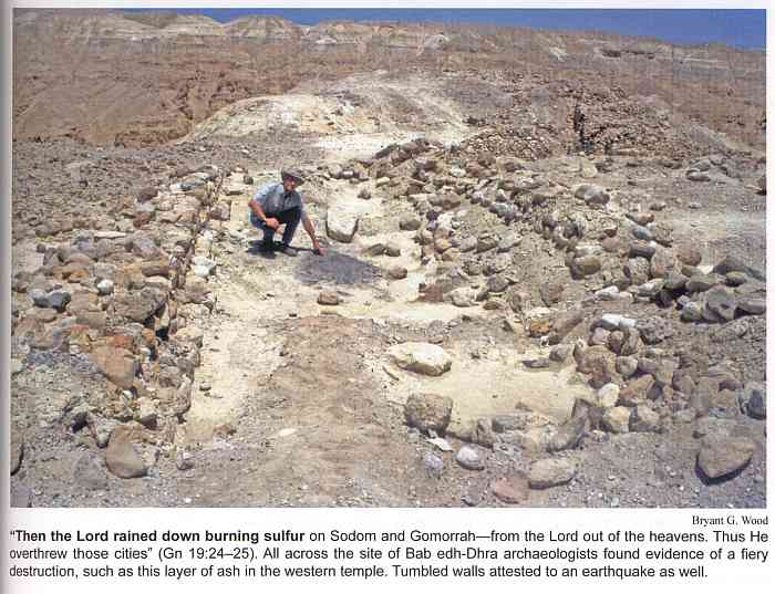
Sodom and Gomorrah in Jordan?
Ω
Complete article
Russia and Jordan have signed an agreement to search the bottom of the Dead Sea for the remains of the Biblical cities of Sodom and Gomorrah, Arabic news media reported over the weekend...
Biblical archaeologists have several theories as to where the Sodom and its associated cities were located. According to the Torah, God overturned Sodom, Gomorrah, and three other cities because of their degeneration, sin and iniquity, turning a once fertile plain into a stark wasteland. Abraham, who prayed for the cities, was unable to prevent God from mandating their destruction.
...Research has centered on the area around the Dead Sea, and the modern city of Sodom, and nearby Mount Sodom, which is made almost completely of rock salt, is considered the most likely site of the ancient cities.
However, some archaeological evidence has emerged that indicates that the site could be on the east bank of the Dead Sea, with two sites in Jordan - Bab edh-Dhra, and Numeira, both considered viable candidates. The Jordanian-Russian search will center on Bab edh-Dhra, which also has several Christian monuments...

More info
Ω
Complete article
Russia and Jordan have signed an agreement to search the bottom of the Dead Sea for the remains of the Biblical cities of Sodom and Gomorrah, Arabic news media reported over the weekend...
Biblical archaeologists have several theories as to where the Sodom and its associated cities were located. According to the Torah, God overturned Sodom, Gomorrah, and three other cities because of their degeneration, sin and iniquity, turning a once fertile plain into a stark wasteland. Abraham, who prayed for the cities, was unable to prevent God from mandating their destruction.
...Research has centered on the area around the Dead Sea, and the modern city of Sodom, and nearby Mount Sodom, which is made almost completely of rock salt, is considered the most likely site of the ancient cities.
However, some archaeological evidence has emerged that indicates that the site could be on the east bank of the Dead Sea, with two sites in Jordan - Bab edh-Dhra, and Numeira, both considered viable candidates. The Jordanian-Russian search will center on Bab edh-Dhra, which also has several Christian monuments...
More info
Ω
Fascinating report on a pre-historic site in the Nazareth hills of lower Galilee
Ω
Investigations at Kfar HaHoresh, a small site nestled in the Nazareth hills of lower Galilee, have revealed a stratigraphic sequence spanning the early through to the late Pre-Pottery Neolithic B (PPNB). Thirteen painstaking excavation seasons have demonstrated tremendous potential for exploring mortuary, ritual, subsistence and industrial activities in this region, and allow a glimpse into an exciting era in human prehistory.
PPNB (ca. 8500-6750 calBC) corresponds to the period when the first large village communities were established in the fertile areas of the Near East. At this time the sphere of cultural interaction had widened, stretching from central Anatolia to southern Sinai and included Cyprus. Rectilinear houses became commonplace, while public and ritual architecture are also found. Although hunting and gathering remained important, plants and animals were becoming increasingly domesticated. Evidence shows there was intensive ritual activity, and prestige items were exchanged over considerable distances....
Read more
Ω
Earliest modern man evolved in Israel?
Ω
Complete article
Eight human teeth dating back as far as 400,000 years ago and found at the prehistoric Qesem Cave near Rosh Ha’ayin – discovered recently by Tel Aviv University researchers – are “the world’s earliest evidence” of modern man (Homo sapiens)...
Until now, remains of humans from only 200,000 years ago have been found in Africa, and the accepted approach has been that modern man originated on that continent.
An international team of scientists performed a morphological analysis on the teeth found in the cave....The examination included CT scans and X-rays indicating the size and shape of the teeth are very similar to those of modern man. The teeth found in the cave are also very similar to evidence of modern man dated to around 100,000 years ago that had previously been discovered in the Skhul Cave on Mount Carmel and the Qafzeh Cave in the Lower Galilee near Nazareth.
The Qesem Cave is dated between 400,000 and 200,000 years ago, and archeologists working there believe that the findings indicate significant changes in the behavior of ancient man. This period of time was crucial in the history of mankind from cultural and biological perspectives, and the fact that teeth of modern man were discovered indicates that these changes are apparently related to evolutionary changes taking place at that time, they maintained.
...The findings that characterize the culture of those who dwelled in the Qesem Cave – the systematic production of flint blades, the habitual use of fire, evidence of hunting, cutting and sharing of animal meat, mining raw materials to produce flint tools from subsurface sources and much more – reinforce the hypothesis that this was, in fact, innovative and pioneering behavior that corresponds with the appearance of modern man...
According to the researchers, the discoveries made in the Qesem Cave may change the perception that has been widely accepted to date in which modern man originated on the continent of Africa
Wednesday, December 8, 2010
2,000 year-old intact carving of Cupid found in Jerusalem
Ω
An intact carving of Cupid made of blue onyx dating from the Roman period was unearthed in the parking lot near the City of David, the Antiquities Authority announced on Monday.
The 2,000-year-old Cupid, about a centimeter long, was probably from a piece of jewelry.
The inlaid stone features cupid holding an upsidedown torch, which was used to symbolize the cessation of life. The piece is part of a series of archeological finds in the area that deal with images of mourning.
Complete article and picture
Ancient Jericho: the largest carpet mosaic in the Middle East
Ω
The small red, blue and ochre square stones, measuring nearly 900 square meters (9,700 square feet) are laid out in complex geometric and floral patterns. They cover the floor of the main bath house of an Islamic palace that was destroyed by an earthquake in the eighth century. Since being excavated in the 1930s and 1940s, the mosaic has largely remained hidden under layers of canvas and soil to protect it against sun and rain.

Visitors look at part of a mosaic, measuring around 9,700 square feet (900 square meters), in ruins of an 8th-century Islamic palace outside the West bank town of Jericho.
A small section will be laid bare for a week, as part of Jericho's 10,000th birthday celebrations. The mosaic then will be covered up again until the money is found to build a roof that would serve as a permanent weather shield, said Palestinian archaeologist Hamdan Taha. Marking the 10,000th birthday is entirely random, though, with archaeologists saying they could be off by hundreds of years in dating the first human settlement in the area.
Hamad said it's the largest carpet mosaic in the Middle East, a claim backed by Marwan Abu Khalaf, an archaeology professor at Al-Quds university and a fellow at the W.F. Albright Institute of Archaeological Research in Jerusalem. Abu Khalaf said the fine workmanship suggests that the Umayyads hired master artists instead of ordinary craftsmen to lay the mosaic.
Tel Shikmona - 6th-century floor mosaics
IIntricate 6th-century floor mosaics have been uncovered at Tel Shikmona park in the North, the University of Haifa has announced.
The mosaics were unearthed by researchers from the university’s Institute of Archeology, who were taking part in renewed digs at the site. Archeological digs were held at Tel Shikmona throughout the 1960s and 1970s, but the site was neglected for decades and became strewn with trash. Since the discovery was made, researchers have been working to remove the built-up garbage and clean the mosaic floors to prepare them for viewing by the public.
Researchers say the well-preserved mosaics date back to the Byzantine period and were part of an ecclesiastic structure.
A number of archeological finds have been discovered at the seaside site south of Haifa, including an Egyptian tomb, a Persian citadel and a number of luxury items from the Bronze Age.
Earlier finds have shown that Shikmona was inhabited over a range of time from the Bronze Age to the Byzantine period, and was the main city of the Haifa and Carmel area from the 4th century BCE to the Muslim conquest in the 7th century CE.
Great article and pictures - King Herod's Retreat

Painted "windows" and blocks of color—as well as a crude wall (center) added after the theater had been closed—add drama to King Herod's royal theater box at Herodium, site of one of his palaces and his mausoleum in what's now the West Bank.
You absolutely must see this.
Tel Esur, a Canaanite settlement dating back to the Bronze Age
A Canaanite settlement dating back to the Bronze Age, Tel Esur, has been exposed at a unique excavation project - the biggest community dig ever to be held in Israel, conducted by University of Haifa researchers with high school students from schools in Israel’s Menashe region, north of Tel Aviv and south of Haifa.
The professional team and participating youngsters have been excavating an impressive system of ancient fortifications and were taken by surprise as they unexpectedly uncovered a remarkable administration structure from after the Assyrian conquest of Israel (late 8th/early 7th century B.C.E.). At the current excavation season, archaeologists and students also managed to reveal a destruction layer that has been dated back to the late Bronze Age (13th century B.C.E.).
The professional team and participating youngsters have been excavating an impressive system of ancient fortifications and were taken by surprise as they unexpectedly uncovered a remarkable administration structure from after the Assyrian conquest of Israel (late 8th/early 7th century B.C.E.). At the current excavation season, archaeologists and students also managed to reveal a destruction layer that has been dated back to the late Bronze Age (13th century B.C.E.).
Monday, December 6, 2010
Greek trade city in Egypt's Nile delta region
Ω
Naukrtis, a Greek trade emporium on Egyptian soil, has long captured the imagination of archaeologists and historians. Not only is the presence of a Greek trading settlement in Egypt during the 7th and 6th century B.C.E. surprising, but the Greeks that lived there in harmony hailed from several Greek states which traditionally warred amongst themselves.
Dr. Alexander Fantalkin of Tel Aviv University's Department of Archaeology is delving deeper into this unique piece of ancient history to come up with a new explanation for how Naukrtis developed, and how its inhabitants managed to operate on foreign soil and create a new sense of common identity.
The Greeks that inhabited Naukrtis, explains Dr. Fantalkin, may have come from warring city states at home, but they formed a trade settlement in Egypt under the protection of powerful Eastern empires. This link not only brought them together as a culture, but explains how they were allowed to operate in the midst of Egyptian territory. Dr. Fantalkin's theory was recently presented at the Cultural Contexts in Antiquity conference in Innsbruck, Austria, and will soon be published in the proceedings of the conference.
Making the best of oppression
Naukrtis is remarkable for two main reasons, Dr. Fantalkin says. First, the Egyptian empire allowed Greeks to operate a lucrative trade emporium at the delta of the Nile, complete with special privileges. Second, the Greeks who lived there, though from different tribes, lived and worshipped together, pointing to the emergence of a national Greek identity. The city also acted as a symbiotic nexus for the interchange of Greek and Egyptian art and culture.
How this arrangement came to be has always puzzled researchers, Dr. Fantalkin notes, explaining his new theory about Naukrtis. In Eastern Greece, the Greeks were plagued by powerful Eastern empires such as Lydia, which was located in the central and western parts of current day Turkey. The Greeks were forced to operate under the Lydian regime, paying tribute to their overlords.
Despite this situation, the so-called Eastern Greeks continued to lead advances in material culture and intellectual achievements. They were also politically savvy, Dr. Fantalkin says, when it came to economics. At the time Naukrtis was created, Lydia had a formal alliance with the Egyptian empire. A select group of Greek businessmen used this connection to set up a trade emporium — they paid tribute to their Lydian benefactors and were guaranteed rights and freedoms as Greek representatives of the Lydian empire. Thus, they made the best of an oppressive regime.
The land of the free?
Previous theories suggested that the Greek traders settled in Naukratis of their own free will, creating a brotherhood of merchants in the process, indifferent to interstate rivalries at home and bound firmly by a common interest in trade. In reality, Prof. Fantalkin speculates, they operated as formal representatives of the Lydian power.
"On one hand," he continues, "the Greeks were given new opportunities for trade. On the other, they owed taxes to the empire that ruled over them. This was not a free settlement of Greek merchants as was previously thought, but an organized move on behalf of a more formidable empire."
Naukratis, in his opinion, should be considered a unique and particularly important instance of "contact zones" in antiquity, in which Greek trade, although controlled by the Egyptians and mediated to a certain extant by the Lydians, both contributed to and profited from the imperial ambitions of others.
Wednesday, December 1, 2010
A 1,800 Year Old Bathing Pool Discovered beneath a Miqve
Ω
An 1,800 year old bathing pool that was probably part of a bathhouse used by the Tenth Legion – the Roman soldiers who destroyed the Temple – was exposed in excavations the Israel Antiquities Authority.

The discovery sheds light on the scope of Aelia Capitolina, the city that was founded on the Second Temple period ruins of Jerusalem and that defined the character of ancient Jerusalem as we know it today.
A Roman bathing pool – part of a bathhouse from the second-third centuries CE – was uncovered in archaeological excavations the Israel Antiquities Authority is conducting at the initiative of the Jerusalem Municipality and the Moriah Company for the Development of Jerusalem, prior to the construction of a men’s miqve in the Jewish Quarter of Jerusalem.
According to Dr. Ofer Sion, excavation director on behalf of the Israel Antiquities Authority, “We were surprised to discover an ancient bathhouse structure right below the spot where a miqve is to be built. During the excavation we uncovered a number of plastered bathtubs in the side of the pool. Incorporated in the side of the pool is a pipe used to fill it with water and on the floor of the pool is a white industrial mosaic pavement. The bathhouse tiles, which are stamped with the symbols of the Tenth Legion “Fretensis” – LEG X FR, were found in situ and it seems that they were used to cover a rock-hewn water channel located at the bottom of the pool. The hundreds of terra cotta roof tiles that were found on the floors of the pool indicate it was a covered structure. The mark of the soldiers of the Tenth Legion, in the form of the stamped impressions on the roof tiles and the in situ mud bricks, bears witness to the fact that they were the builders of the structure. It seems that the bathhouse was used by these soldiers who were garrisoned there after suppressing the Bar Kokhba uprising in 135 CE, when the pagan city Aelia Capitolina was established. We know that the Tenth Legion’s camp was situated within the limits of what is today the Old City, probably in the region of the Armenian Quarter. This assumption is reinforced by the discovery of the bathhouse in the nearby Jewish Quarter which shows that the multitude of soldiers was spread out and that they were also active outside the camp, in other parts of the Old City”.
Dr. Sion adds, “Another interesting discovery that caused excitement during the excavation is the paw print of a dog that probably belonged to one of the soldiers. The paw print was impressed on the symbol of the legion on one of the roof tiles and it could have happened accidentally or have been intended as a joke”.
According to Dr. Yuval Baruch, the Jerusalem District archaeologist of the Israel Antiquities Authority, “What we have here is a discovery that is important for the study of Jerusalem. Despite the very extensive archaeological excavations that were carried out in the Jewish Quarter, so far not even one building has been discovered there that belonged to the Roman legion. The absence of such a find led to the conclusion that Aelia Capitolina, the Roman city which was established after the destruction of Jerusalem, was small and limited in area. The new find, together with other discoveries of recent years, shows that the city was considerably larger than what we previously estimated. Information about Aelia Capitolina is extremely valuable and can contribute greatly to research on Jerusalem because it was that city that determined the character and general appearance of ancient Jerusalem and as we know it today. The shape of the city has determined the outline of its walls and the location of the gates to this very day”.
The Israel Antiquities Authority reports that the remains of the ancient Roman bathhouse which were uncovered will be integrated in the new miqve slated to be built in the Jewish Quarter.
Sunday, November 28, 2010
The Israel Antiquities Authority is very embarrassed
I posted in August about a fabulous new discovery in Israel of an ancient bracelet
Well, turns out it wasn't all that old - early 20th century!
Read all about it here.
The Israel Antiquities Authority is obviously very embarrassed.
.
The Israel Antiquities Authority has announced the discovery of a unique bracelet in an excavation in northern Israel, dating back to the Late Bronze Age
Well, turns out it wasn't all that old - early 20th century!
Read all about it here.
The Israel Antiquities Authority is obviously very embarrassed.
Wednesday, November 24, 2010
DNA Reveals Origins of First European Farmers
Ω
A team of international researchers led by ancient DNA experts from the University of Adelaide has resolved the longstanding issue of the origins of the people who introduced farming to Europe some 8000 years ago.
A detailed genetic study of one of the first farming communities in Europe, from central Germany, reveals marked similarities with populations living in the Ancient Near East (modern-day Turkey, Iraq and other countries) rather than those from Europe.
Project leader Professor Alan Cooper, Director of the Australian Centre for Ancient DNA (ACAD) at the University of Adelaide, says: "This overturns current thinking, which accepts that the first European farming populations were constructed largely from existing populations of hunter-gatherers, who had either rapidly learned to farm or interbred with the invaders."
The results of the study have been published today in the online peer-reviewed science journal PLoS Biology.
"We have finally resolved the question of who the first farmers in Europe were -- invaders with revolutionary new ideas, rather than populations of Stone Age hunter-gatherers who already existed in the area," says lead author Dr Wolfgang Haak, Senior Research Associate with ACAD at the University of Adelaide.
"We've been able to apply new, high-precision ancient DNA methods to create a detailed genetic picture of this ancient farming population, and reveal that it was radically different to the nomadic populations already present in Europe.
"We have also been able to use genetic signatures to identify a potential route from the Near East and Anatolia, where farming evolved around 11,000 years ago, via south-eastern Europe and the Carpathian Basin (today's Hungary) into Central Europe," Dr Haak says.
The project involved researchers from the University of Mainz and State Heritage Museum in Halle, Germany, the Russian Academy of Sciences and members of the National Geographic Society's Genographic Project, of which Professor Cooper is a Principal Investigator and Dr Haak is a Senior Research Associate.
The ancient DNA used in this study comes from a complete graveyard of Early Neolithic farmers unearthed at the town of Derenburg in Saxony-Anhalt, central Germany.
"This work was only possible due to the close collaboration of archaeologists excavating the skeletons, to ensure that no modern human DNA contaminated the remains, and nicely illustrates the potential when archaeology and genetics are combined," says Professor Kurt Werner Alt from the collaborating Institute of Anthropology in Mainz, Germany.
Researchers Unearth Ancient Water Secrets at Royal Garden Dig
Ω
Ancient gardens are the stuff of legend, from the Garden of Eden to the Hanging Gardens of Babylon. Now researchers at Tel Aviv University, in collaboration with Heidelberg University in Germany, have uncovered an ancient royal garden at the site of Ramat Rachel near Jerusalem, and are leading the first full-scale excavation of this type of archaeological site anywhere in the pre-Hellenistic Levant.
According to Prof. Oded Lipschits and graduate student Boaz Gross of Tel Aviv University's Department of Archaeology, this dig is an unparalleled look into the structure and function of ancient gardens. "We have uncovered a very rare find," says Prof. Lipschits, who believes that this excavation will lead to invaluable archaeological knowledge about ancient royal gardens in the Middle East.
The discovery, which dates back to the 7th century B.C.E., was recently reported in Quadmoniot, the journal of the Israel Exploration Society, and another paper on the dig is forthcoming in Near Eastern Archaeology.
Flower power in the ancient world
According to Gross, such gardens were once the ultimate symbol of power. It makes an obvious statement of status, he explains, to have a massive and lush green space surrounding one's palace, especially when the surrounding area is bare, as it would have been in the dry climate of the Judean Hills only two miles from the Old City of Jerusalem. In fact, he says, the garden would have been the most prominent feature of Ramat Rachel, visible from the west, north and south.
One of the dig's most important aspects is water management. In ancient times, control over water indicated political strength, says Gross. A main feature of the Ramat Rachel gardens is its intricate irrigation system, the likes of which have never been seen before outside of Mesopotamia. Features include open channels and closed tunnels, stone carved gutters and the framework for elaborate waterfalls.
In similar Assyrian gardens, trees and plants would have been brought in from all over the empire, explains Prof. Lipschits, who says that this type of garden, also in the Babylonian or Persian kingdoms, would have also served a spiritual function as a place of peace, tranquillity and connection to nature.
A global village?
Preliminary results show that while Ramat Rachel was built by the Judeans, the people of the ancient kingdom of Judah, it was commissioned by foreign powers. These results may reveal information about a wide variety of empires that ruled in Israel at one time. This site, says Gross, was in use from the 7th to the 4th century B.C.E., a time period which saw many wars and exchanges of power with the garden evolving under each civilization.
Researchers are excited about what more this unique dig will be able to tell them. There has never been anything like it, explains Gross, who says that the TAU team will be pioneering a method for excavating gardens. "Proper excavation will provide an essential tool to future researchers," he says. "We are carefully deciphering what we have in front of us. There are no parallels to it."
The team hopes to delve deeper into the history of the garden with a close analysis of soil and other findings to determine what kind of plant life would have grown there, and which, if any, animals called the garden home.
Monday, October 4, 2010
A 1,500 Year Old Samaritan Synagogue Discovered
Ω
A Samaritan synagogue, c. 1,500 years old, was discovered before the holidays, southwest of Bet She’an.
The remains of a synagogue and farmstead that operated in the Late Byzantine period, which were unknown until now, were exposed in an archaeological excavation conducted on behalf of the Israel Antiquities Authority and underwritten by the Ministry of Construction and Housing, prior to enlarging a residential quarter south of Bet She`an, c. one half kilometer west of the Jordan Valley highway (Route 90).

According to Dr. Walid Atrash and Mr. Ya’aqov Harel, directors of the excavation for the Israel Antiquities Authority, “The discovery of another Samaritan synagogue in the agricultural hinterland south of Bet She’an supplements our existing knowledge about the Samaritan population in this period. It seems that the structures uncovered there were built at the end of the fifth century CE and they continued to exist until the eve of the Muslim conquest in 634 CE, when the Samaritans abandoned the complex. The synagogue that is currently being revealed played an important part in the lives of the farmers who inhabited the surrounding region, and it served as a center of the spiritual, religious and social life there. In the Byzantine period (fourth century CE) Bet She’an became an important Samaritan center under the leadership of Baba Rabbah, at which time the Samaritans were granted national sovereignty and were free to decide their own destiny. This was the case until the end of the reign of Emperor Justinian, when the Samaritans revolted against the government. The rebellion was put down and the Samaritans ceased to exist as a nation”.
The building that was exposed consisted of a rectangular hall (5 x 8 meters), the front of which faces southwest, toward Mount Gerizim, which is sacred to Samaritans. Five rectangular recesses were built in the walls of the prayer hall in which wooden benches were probably installed. The floor of the hall was a colorful mosaic, decorated with a geometric pattern. In the center of the mosaic is a Greek inscription, of which a section of its last line was revealed:T[]OUTON NEWN meaning “This is the temple”.

According to Dr. Leah Di Segni of the Hebrew University of Jerusalem, who translated the inscription, the plan of the building, its orientation and the content of the inscription are in keeping with a Samaritan synagogue.
It is well-known that two Samaritan synagogues were discovered in the past at Bet Sheʽan. One is called “Bet Leontis” and it consists of a complex of rooms arranged around a courtyard; a small prayer room (7 x 7 meters) that served as part of a hostel is located in the south of that building. The second – the Samaritan synagogue, located on Tel Iztabba – is situated outside the Byzantine city walls.
A farmstead that extends over an area in excess of 1,500 square meters was exposed next to the synagogue. The farmhouse was composed of a central courtyard surrounded by storerooms and in its southern part there was a residence, a guest hall and industrial installations.
A Samaritan synagogue, c. 1,500 years old, was discovered before the holidays, southwest of Bet She’an.
The remains of a synagogue and farmstead that operated in the Late Byzantine period, which were unknown until now, were exposed in an archaeological excavation conducted on behalf of the Israel Antiquities Authority and underwritten by the Ministry of Construction and Housing, prior to enlarging a residential quarter south of Bet She`an, c. one half kilometer west of the Jordan Valley highway (Route 90).
According to Dr. Walid Atrash and Mr. Ya’aqov Harel, directors of the excavation for the Israel Antiquities Authority, “The discovery of another Samaritan synagogue in the agricultural hinterland south of Bet She’an supplements our existing knowledge about the Samaritan population in this period. It seems that the structures uncovered there were built at the end of the fifth century CE and they continued to exist until the eve of the Muslim conquest in 634 CE, when the Samaritans abandoned the complex. The synagogue that is currently being revealed played an important part in the lives of the farmers who inhabited the surrounding region, and it served as a center of the spiritual, religious and social life there. In the Byzantine period (fourth century CE) Bet She’an became an important Samaritan center under the leadership of Baba Rabbah, at which time the Samaritans were granted national sovereignty and were free to decide their own destiny. This was the case until the end of the reign of Emperor Justinian, when the Samaritans revolted against the government. The rebellion was put down and the Samaritans ceased to exist as a nation”.
The building that was exposed consisted of a rectangular hall (5 x 8 meters), the front of which faces southwest, toward Mount Gerizim, which is sacred to Samaritans. Five rectangular recesses were built in the walls of the prayer hall in which wooden benches were probably installed. The floor of the hall was a colorful mosaic, decorated with a geometric pattern. In the center of the mosaic is a Greek inscription, of which a section of its last line was revealed:T[]OUTON NEWN meaning “This is the temple”.
According to Dr. Leah Di Segni of the Hebrew University of Jerusalem, who translated the inscription, the plan of the building, its orientation and the content of the inscription are in keeping with a Samaritan synagogue.
It is well-known that two Samaritan synagogues were discovered in the past at Bet Sheʽan. One is called “Bet Leontis” and it consists of a complex of rooms arranged around a courtyard; a small prayer room (7 x 7 meters) that served as part of a hostel is located in the south of that building. The second – the Samaritan synagogue, located on Tel Iztabba – is situated outside the Byzantine city walls.
A farmstead that extends over an area in excess of 1,500 square meters was exposed next to the synagogue. The farmhouse was composed of a central courtyard surrounded by storerooms and in its southern part there was a residence, a guest hall and industrial installations.
Thursday, September 30, 2010
No evidence for Clovis comet catastrophe, archaeologists say
Ω
New research challenges the controversial theory that an ancient comet impact devastated the Clovis people, one of the earliest known cultures to inhabit North America.
Writing in the October issue of Current Anthropology, archaeologists Vance Holliday (University of Arizona) and David Meltzer (Southern Methodist University) argue that there is nothing in the archaeological record to suggest an abrupt collapse of Clovis populations. "Whether or not the proposed extraterrestrial impact occurred is a matter for empirical testing in the geological record," the researchers write. "Insofar as concerns the archaeological record, an extraterrestrial impact is an unnecessary solution for an archaeological problem that does not exist."
The comet theory first emerged in 2007 when a team of scientists announced evidence of a large extraterrestrial impact that occurred about 12,900 years ago. The impact was said to have caused a sudden cooling of the North American climate, killing off mammoths and other megafauna. It could also explain the apparent disappearance of the Clovis people, whose characteristic spear points vanish from the archaeological record shortly after the supposed impact.
As evidence for the rapid Clovis depopulation, comet theorists point out that very few Clovis archaeological sites show evidence of human occupation after the Clovis. At the few sites that do, Clovis and post-Clovis artifacts are separated by archaeologically sterile layers of sediments, indicating a time gap between the civilizations. In fact, comet theorists argue, there seems to be a dead zone in the human archaeological record in North America beginning with the comet impact and lasting about 500 years.

These are Clovis Points.
But Holliday and Meltzer dispute those claims. They argue that a lack of later human occupation at Clovis sites is no reason to assume a population collapse. "Single-occupation Paleoindian sites—Clovis or post-Clovis—are the norm," Holliday said. That's because many Paleoindian sites are hunting kill sites, and it would be highly unlikely for kills to be made repeatedly in the exact same spot.
"So there is nothing surprising about a Clovis occupation with no other Paleoindian zone above it, and it is no reason to infer a disaster," Holliday said.
In addition, Holliday and Meltzer compiled radiocarbon dates of 44 archaeological sites from across the U.S. and found no evidence of a post-comet gap. "Chronological gaps appear in the sequence only if one ignores standard deviations (a statistically inappropriate procedure), and doing so creates gaps not just around [12,900 years ago] but also at many later points in time," they write.
Sterile layers separating occupation zones at some sites are easily explained by shifting settlement patterns and local geological processes, the researchers say. The separation should not be taken as evidence of an actual time gap between Clovis and post-Clovis cultures.
Holliday and Meltzer believe that the disappearance of Clovis spear points is more likely the result of a cultural choice rather than a population collapse. "There is no compelling data to indicate that North American Paleoindians had to cope with or were affected by a catastrophe, extraterrestrial or otherwise, in the terminal Pleistocene," they conclude.
Saturday, September 25, 2010
Construction Secrets of Ancient Egypt's Pyramids
Ω
Scientists from around the world have tried to understand how the Egyptians erected their giant pyramids. Now, an architect and researcher at the Norwegian University of Science and Technology (NTNU) says he has the answer to this ancient, unsolved puzzle.
Researchers have been so preoccupied by the weight of the stones that they tend to overlook two major problems: How did the Egyptians know exactly where to put the enormously heavy building blocks? And how was the master architect able to communicate detailed, highly precise plans to a workforce of 10,000 illiterate men?
A 7-million-ton structure
These were among the questions that confronted Ole J. Bryn, an architect and associate professor in NTNU's Faculty of Architecture and Fine Art when he began examining Khufu's Great Pyramid in Giza. Khufu's pyramid, better known as the Pyramid of Cheops, consists of 2.3 million limestone blocks weighing roughly 7 million tons. At 146.6 meters high, it held the record as the tallest structure ever built for nearly 4000 years.
What Bryn discovered was quite simple. He believes that the Egyptians invented the modern building grid, by separating the structure's measuring system from the physical building itself, thus introducing tolerance, as it is called in today's engineering and architectural professions.
The apex point a key
Bryn has studied the plans from the thirty oldest Egyptian pyramids, and discovered a precision system that made it possible for the Egyptians to reach the pyramid's last and highest point, the apex point, with an impressive degree of accuracy. By exploring and making a plan of the pyramid it is possible to prepare modern project documentation of not just one, but all pyramids from any given period.
As long as the architect knows the main dimensions of a pyramid, he can project the building as he would have done it with a modern building, but with building methods and measurements known from the ancient Egypt, Bryn says.
In a scientific article published May 2010 in the Nordic Journal of Architectural Research, Bryn discusses aspects that can explain the construction of a multitude of the Egyptian pyramids by taking the building grid, and not the physical building itself, as the starting point for the analysis.
A new map
If the principles behind Bryn's drawings are correct, then archaeologists will have a new "map" that demonstrates that the pyramids are not a "bunch of heavy rocks with unknown structures" but, rather, incredibly precise structures.
Ole J. Bryn's findings will be presented and explained at the exhibition The Apex Point in Trondheim from September 13th to October 1st. The exhibition is an official part of the program to celebrate the centenary (1910-2010) of the Norwegian University of Science and Technology.
About the author:
Ole J. Bryn is a former practising architect, and currently holds a position as Associate Professor at the Faculty of Architecture and Fine Art, the Norwegian University of Science and Technology (NTNU) in Trondheim, Norway.
The development of Bryn's theories on the building grids used in Egyptian pyramids has benefited from cooperation with Dr. Michel Barsoum, Grosvenor and Distinguished Professor at the Department of Materials Science and Engineering, Drexel University, Philadelphia.
Thursday, September 23, 2010
Neanderthals More Advanced Than Previously Thought: They Innovated, Adapted Like Modern Humans
Ω
For decades scientists believed Neanderthals developed `modern' tools and ornaments solely through contact with Homo sapiens, but new research from the University of Colorado Denver now shows these sturdy ancients could adapt, innovate and evolve technology on their own.
The findings by anthropologist Julien Riel-Salvatore challenge a half-century of conventional wisdom maintaining that Neanderthals were thick-skulled, primitive `cavemen' overrun and outcompeted by more advanced modern humans arriving in Europe from Africa.
"Basically, I am rehabilitating Neanderthals," said Riel-Salvatore, assistant professor of anthropology at UC Denver. "They were far more resourceful than we have given them credit for."
His research, to be published in December's Journal of Archaeological Method and Theory, was based on seven years of studying Neanderthal sites throughout Italy, with special focus on the vanished Uluzzian culture.
About 42,000 years ago, the Aurignacian culture, attributed to modern Homo sapiens, appeared in northern Italy while central Italy continued to be occupied by Neanderthals of the Mousterian culture which had been around for at least 100,000 years. At this time a new culture arose in the south, one also thought to be created by Neanderthals. They were the Uluzzian and they were very different.
Riel-Salvatore identified projectile points, ochre, bone tools, ornaments and possible evidence of fishing and small game hunting at Uluzzian archeological sites throughout southern Italy. Such innovations are not traditionally associated with Neanderthals, strongly suggesting that they evolved independently, possibly due to dramatic changes in climate. More importantly, they emerged in an area geographically separated from modern humans.
"My conclusion is that if the Uluzzian is a Neanderthal culture it suggests that contacts with modern humans are not necessary to explain the origin of this new behavior. This stands in contrast to the ideas of the past 50 years that Neanderthals had to be acculturated to humans to come up with this technology," he said. "When we show Neanderthals could innovate on their own it casts them in a new light. It `humanizes' them if you will."
Thousands of years ago, southern Italy experienced a shift in climate, becoming increasingly open and arid, said Riel-Salvatore. Neanderthals living there faced a stark choice of adapting or dying out. The evidence suggests they began using darts or arrows to hunt smaller game to supplement the increasingly scarce larger mammals they traditionally hunted.
"The fact that Neanderthals could adapt to new conditions and innovate shows they are culturally similar to us," he said. "Biologically they are also similar. I believe they were a subspecies of human but not a different species."
The powerfully built Neanderthals were first discovered in Germany's Neander Valley in 1856. Exactly who they were, how they lived and why they vanished remains unclear.
Research shows they contributed between 1 and 4 percent of their genetic material to the people of Asia and Europe. Riel-Salvatore rejects the theory that they were exterminated by modern humans. Homo sapiens might simply have existed in larger groups and had slightly higher birthrates, he said.
"It is likely that Neanderthals were absorbed by modern humans," he said. "My research suggests that they were a different kind of human, but humans nonetheless. We are more brothers than distant cousins."
Tuesday, September 21, 2010
Applying Physics to Red Sea Escape Route
Ω
The biblical account of the parting of the Red Sea has inspired and mystified people for millennia. A new computer modeling study by researchers at the National Center for Atmospheric Research (NCAR) and the University of Colorado at Boulder (CU) shows how the movement of wind as described in the book of Exodus could have parted the waters.
The computer simulations show that a strong east wind, blowing overnight, could have pushed water back at a bend where an ancient river is believed to have merged with a coastal lagoon along the Mediterranean Sea. With the water pushed back into both waterways, a land bridge would have opened at the bend, enabling people to walk across exposed mud flats to safety. As soon as the wind died down, the waters would have rushed back in.

The study is intended to present a possible scenario of events that are said to have taken place more than 3,000 years ago, although experts are uncertain whether they actually occurred. The research was based on a reconstruction of the likely locations and depths of Nile delta waterways, which have shifted considerably over time.
"The simulations match fairly closely with the account in Exodus," says Carl Drews of NCAR, the lead author. "The parting of the waters can be understood through fluid dynamics. The wind moves the water in a way that's in accordance with physical laws, creating a safe passage with water on two sides and then abruptly allowing the water to rush back in."
The study is part of a larger research project by Drews into the impacts of winds on water depths, including the extent to which Pacific Ocean typhoons can drive storm surges. By pinpointing a possible site south of the Mediterranean Sea for the crossing, the study also could be of benefit to experts seeking to research whether such an event ever took place. Archeologists and Egyptologists have found little direct evidence to substantiate many of the events described in Exodus.
The work, published in the online journal, PLoS ONE, arose out of Drews' master's thesis in atmospheric and oceanic sciences at CU. The computing time and other resources were supported by the National Science Foundation.
-----Wind on the water -----
The Exodus account describes Moses and the fleeing Israelites trapped between the Pharaoh's advancing chariots and a body of water that has been variously translated as the Red Sea or the Sea of Reeds. In a divine miracle, the account continues, a mighty east wind blows all night, splitting the waters and leaving a passage of dry land with walls of water on both sides. The Israelites are able to flee to the other shore. But when the Pharaoh's army attempts to pursue them in the morning, the waters rush back and drown the soldiers.
Scientists from time to time have tried to study whether the parting of the waters, one of the famous miracles in the Bible, can also be understood through natural processes. Some have speculated about a tsunami, which would have caused waters to retreat and advance rapidly. But such an event would not have caused the gradual overnight divide of the waters as described in the Bible, nor would it necessarily have been associated with winds.
Other researchers have focused on a phenomenon known as "wind setdown," in which a particularly strong and persistent wind can lower water levels in one area while piling up water downwind. Wind setdowns, which are the opposite of storm surges, have been widely documented, including an event in the Nile delta in the 19th century when a powerful wind pushed away about five feet of water and exposed dry land.
A previous computer modeling study into the Red Sea crossing by a pair of Russian researchers, Naum Voltzinger and Alexei Androsov, found that winds blowing from the northwest at minimal hurricane force (74 miles per hour) could, in theory, have exposed an underwater reef near the modern-day Suez Canal. This would have enabled people to walk across. The Russian study built on earlier work by oceanographers Doron Nof of Florida State University and Nathan Paldor of Hebrew University of Jerusalem that looked at the possible role of wind setdown.
The new study, by Drews and CU oceanographer Weiqing Han, found that a reef would have had to be entirely flat for the water to drain off in 12 hours. A more realistic reef with lower and deeper sections would have retained channels that would have been difficult to wade through. In addition, Drews and Han were skeptical that refugees could have crossed during nearly hurricane-force winds.
-----Reconstructing ancient topography-----
Studying maps of the ancient topography of the Nile delta, the researchers found an alternative site for the crossing about 75 miles north of the Suez reef and just south of the Mediterranean Sea. Although there are uncertainties about the waterways of the time, some oceanographers believe that an ancient branch of the Nile River flowed into a coastal lagoon then known as the Lake of Tanis. The two waterways would have come together to form a U-shaped curve.
An extensive analysis of archeological records, satellite measurements, and current-day maps enabled the research team to estimate the water flow and depth that may have existed 3,000 years ago. Drews and Han then used a specialized ocean computer model to simulate the impact of an overnight wind at that site.
They found that a wind of 63 miles an hour, lasting for 12 hours, would have pushed back waters estimated to be six feet deep. This would have exposed mud flats for four hours, creating a dry passage about 2 to 2.5 miles long and 3 miles wide. The water would be pushed back into both the lake and the channel of the river, creating barriers of water on both sides of newly exposed mud flats.
As soon as the winds stopped, the waters would come rushing back, much like a tidal bore. Anyone still on the mud flats would be at risk of drowning.
The set of 14 computer model simulations also showed that dry land could have been exposed in two nearby sites during a windstorm from the east. However, those sites contained only a single body of water and the wind would have pushed the water to one side rather than creating a dry passage through two areas of water.
"People have always been fascinated by this Exodus story, wondering if it comes from historical facts," Drews says. "What this study shows is that the description of the waters parting indeed has a basis in physical laws."
Ω
Thursday, September 16, 2010
Goddess of Fortune found at Sussita
Ω
A wall painting (fresco) of Tyche, the Greek goddess of fortune, was exposed during the 11th season of excavation at the Sussita site, on the east shore of the Sea of Galilee, which was conducted by researchers of the University of Haifa.

Head of Tyche, goddess of fortune, on the fresco
Another female figure was found during this season, of a maenad, one of the companions of the wine god Dionysus.

Maenad figurine
“It is interesting to see that although the private residence in which two goddesses were found was in existence during the Byzantine period, when Christianity negated and eradicated idolatrous cults, one can still find clear evidence of earlier beliefs,” said Prof. Arthur Segal and Dr. Michael Eisenberg of the Zinman Institute of Archaeology at the University of Haifa, who headed the excavation.
The city of Sussita is located within the Sussita National Park under the management of the Israel Nature and Parks Authority, which has accompanied and assisted the excavation teams this season in enabling the continuation of excavation work and the conservation of the archaeological finds.
During the course of the excavations conducted by the team from the University of Concordia under the direction of Prof. Mark Schuler, in a residence that appeared, by the quality and complexity of its construction, to belong to one of the city notables, the excavators reached an inner courtyard with a small fountain at its center. Near the fountain they found a fresco of Tyche, who was apparently deified as the city’s goddess of fortune. Her head is crowned, her youthful gaze is focused, and she has abundant brown hair beneath her crown. According to the researchers, artistic analysis has indicated that the wall painting may be dated to the end of the Roman period or the beginning of the Byzantine period (3rd-4th centuries C.E.).
The goddess Tyche was not the only mythological figure to be discovered in this compound. Found on a bone plate was a wonderfully etched relief of a maenad, one of a group of female followers of Dionysus, the god of wine. According to Greek mythology, the maenads accompanied Dionysus with frenzied dances while holding a thyrsus, a device symbolizing sexuality, fertility, and the male sexual organ associated with sexual pleasure. The maenad of Sussita was also depicted as being in the midst of a frenzied dance. The researchers believe that both manifestations of the cult of Graeco-Roman female goddesses can be dated to the end of the Roman period, but there is no doubt that the residence in which they were found continued to exist even after Christianity triumphed over idolatry.
In this season the city’s Roman period basilica (1st-2nd centuries CE) began to be exposed. This is a large-sized building that incorporated the city’s central commercial, social and judicial areas. Besides the excellent architectural marble items that were unearthed there, the researchers also found decorations made of “stucco”, molded plaster used in the imitation of marble. “We could not fail to wonder how a relatively plebeian city could employ first-class builders and artisans. The stucco decorations demonstrate that despite everything, the city rulers were certainly not sparing of the costs and expenditure of construction,” the researchers noted.
Sussita was erected on a mountain top rising to the east of the Sea of Galilee during the 2nd century B.C.E. by the Seleucid rulers who then controlled the country. The city existed during the Hellenist, Roman, Byzantine and Umayyad periods, until it was destroyed by a violent earthquake in the year 749 C.E. Together with Beth Shean and other cities on the eastern bank of the Jordan River, Sussita was one of the cultural-geographical group of Decapolis cities - a region within which Jesus conducted some of the miracles described in the New Testament.
Ω
Friday, September 3, 2010
From Israel: Evidence of Organized Feasting by Early Humans
Ω
Community feasting is one of the most universal and important social behaviors found among humans. Now, scientists have found the earliest clear evidence of organized feasting, from a burial site dated about 12,000 years ago. These remains represent the first archaeological verification that human feasting began before the advent of agriculture.

This is a view of excavation area at Hilazon Tachtit Cave, Israel. (Credit: Naftali Hilger)
"Scientists have speculated that feasting began before the Neolithic period, which starts about 11.5 thousand years ago," says Natalie Munro of the University of Connecticut, and author of a research article in the Proceedings of the National Academy of Sciences. "This is the first solid evidence that supports the idea that communal feasts were already occurring -- perhaps with some frequency -- at the beginnings of the transition to agriculture."
At a burial cave in the Galilee region of northern Israel, Munro and her colleague Leore Grosman of Hebrew University in Jerusalem uncovered the remains of at least 71 tortoises and three wild cattle in two specifically crafted hollows, an unusually high density for the period. The tortoise shells and cattle bones exhibited evidence of being cooked and torn apart, indicating that the animals had been butchered for human consumption.
Each of the two hollows, says Munro, was manufactured for the purpose of a ritual human burial and related feasting activities. The tortoise shells were situated under, around and on top of the remains of a ritually-buried shaman, which suggests that the feast occurred concurrently with the ritual burial. On their own, the meat from the discarded tortoise shells could probably have fed about 35 people, says Munro, but it's possible that many more than that attended this feast.
"We don't know exactly how many people attended this particular feast, or what the average attendance was at similar events, since we don't know how much meat was actually available in the cave," says Munro. "The best we can do is give a minimum estimate based on the bones that are present."
A major reason why humans began feasting -- and later began to cultivate their own foods -- is because faster human population growth had begun to crowd their landscape. In earlier periods of the Stone Age, says Munro, small family groups were often on the move to find new sources of food. But around the time of this feast, she says, that lifestyle had become much more difficult.
"People were coming into contact with each other a lot, and that can create friction," she says. "Before, they could get up and leave when they had problems with the neighbors. Now, these public events served as community-building opportunities, which helped to relieve tensions and solidify social relationships."
But when a once-nomadic group of humans settles down, that can put tremendous pressure on the local resources. Munro notes that humans around the time of this feast were intensively using the plants and animals that their descendants later domesticated.
"The appearance of these feasts at the beginnings of agriculture is particularly interesting because people are starting to experiment with domestication and cultivation," she notes.
This combination of increased social interaction and changes in resources, says Munro, is what eventually led to the beginnings of agriculture.
"Taken together, this community integration and the changes in economics were happening at the very beginning when incipient cultivation was getting going," she says. "These kinds of social changes are the beginnings of significant changes in human social complexity that lead into the beginning of the agricultural transition."
Thursday, September 2, 2010
Ancient brewers tapped antibiotic secrets
Ω
A chemical analysis of the bones of ancient Nubians shows that they were regularly consuming tetracycline, most likely in their beer. The finding is the strongest evidence yet that the art of making antibiotics, which officially dates to the discovery of penicillin in 1928, was common practice nearly 2,000 years ago.
The research, led by Emory anthropologist George Armelagos and medicinal chemist Mark Nelson of Paratek Pharmaceuticals, Inc., is published in the American Journal of Physical Anthropology.
“We tend to associate drugs that cure diseases with modern medicine,” Armelagos says. “But it’s becoming increasingly clear that this prehistoric population was using empirical evidence to develop therapeutic agents. I have no doubt that they knew what they were doing.”
Armelagos is a bioarcheologist and an expert on prehistoric and ancient diets. In 1980, he discovered what appeared to be traces of tetracycline in human bones from Nubia dated between A.D. 350 and 550, populations that left no written record. The ancient Nubian kingdom was located in present-day Sudan, south of ancient Egypt.
Green fluorescence in Nubian skeletons indicated tetracycline-labeled bone, the first clue that the ancients were producing the antibiotic.
Armelagos and his fellow researchers later tied the source of the antibiotic to the Nubian beer. The grain used to make the fermented gruel contained the soil bacteria streptomyces, which produces tetracycline. A key question was whether only occasional batches of the ancient beer contained tetracycline, which would indicate accidental contamination with the bacteria.
Nelson, a leading expert in tetracycline and other antibiotics, became interested in the project after hearing Armelagos speak at a conference. “I told him to send me some mummy bones, because I had the tools and the expertise to extract the tetracycline,” Nelson says. “It’s a nasty and dangerous process. I had to dissolve the bones in hydrogen fluoride, the most dangerous acid on the planet.”
The results stunned Nelson. “The bones of these ancient people were saturated with tetracycline, showing that they had been taking it for a long time,” he says. “I’m convinced that they had the science of fermentation under control and were purposely producing the drug.”
Even the tibia and skull belonging to a 4-year-old were full of tetracycline, suggesting that they were giving high doses to the child to try and cure him of illness, Nelson says.
The first of the modern day tetracyclines was discovered in 1948. It was given the name auereomycin, after the Latin word “aerous,” which means containing gold. “Streptomyces produce a golden colony of bacteria, and if it was floating on a batch of beer, it must have look pretty impressive to ancient people who revered gold,” Nelson theorizes.
The ancient Egyptians and Jordanians used beer to treat gum disease and other ailments, Armelagos says, adding that the complex art of fermenting antibiotics was probably widespread in ancient times, and handed down through generations.
The chemical confirmation of tetracycline in ancient bones is not the end of the story for Armelagos. He remains enthused after more than three decades on the project. “This opens up a whole new area of research,” he says. “Now we’re going to compare the amount of tetracycline in the bones, and bone formation over time, to determine the dosage that the ancient Nubians were getting.”
Friday, August 20, 2010
Mother of all humans lived 200,000 years ago
Ω
The most robust statistical examination to date of our species' genetic links to "mitochondrial Eve" -- the maternal ancestor of all living humans -- confirms that she lived about 200,000 years ago. The Rice University study was based on a side-by-side comparison of 10 human genetic models that each aim to determine when Eve lived using a very different set of assumptions about the way humans migrated, expanded and spread across Earth.
The research is available online in the journal Theoretical Population Biology.
"Our findings underscore the importance of taking into account the random nature of population processes like growth and extinction," said study co-author Marek Kimmel, professor of statistics at Rice. "Classical, deterministic models, including several that have previously been applied to the dating of mitochondrial Eve, do not fully account for these random processes."
The quest to date mitochondrial Eve (mtEve) is an example of the way scientists probe the genetic past to learn more about mutation, selection and other genetic processes that play key roles in disease.
"This is why we are interested in patterns of genetic variability in general," Kimmel said. "They are very important for medicine."
For example, the way scientists attempt to date mtEve relies on modern genetic techniques. Genetic profiles of random blood donors are compared, and based upon the likenesses and differences between particular genes, scientists can assign a number that describes the degree to which any two donors are related to one another.
Using mitochondrial genomes to gauge relatedness is a way for geneticists to simplify the task of finding common ancestors that lived long ago. That is because the entire human genome contains more than 20,000 genes, and comparing the differences among so many genes for distant relatives is problematic, even with today's largest and fastest supercomputers.
But mitochondria -- the tiny organelles that serve as energy factories inside all human cells -- have their own genome. Besides containing 37 genes that rarely change, they contain a "hypervariable" region, which changes fast enough to provide a molecular clock calibrated to times comparable to the age of modern humanity. Because each person's mitochondrial genome is inherited from his or her mother, all mitochondrial lineages are maternal.
To infer mtEve's age, scientists must convert the measures of relatedness between random blood donors into a measure of time.
"You have to translate the differences between gene sequences into how they evolved in time," said co-author Krzysztof Cyran, vice head of the Institute of Informatics at Silesian University of Technology in Gliwice, Poland. "And how they evolved in time depends upon the model of evolution that you use. So, for instance, what is the rate of genetic mutation, and is that rate of change uniform in time? And what about the process of random loss of genetic variants, which we call genetic drift?"
Within each model, the answers to these questions take the form of coefficients -- numeric constants that are plugged into the equation that returns the answer for when mtEve lived.
Each model has its own assumptions, and each assumption has mathematical implications. To further complicate matters, some of the assumptions are not valid for human populations. For example, some models assume that population size never changes. That is not true for humans, whose population has grown exponentially for at least several thousand generations. Other models assume perfect mixing of genes, meaning that any two humans anywhere in the world have an equal chance of producing offspring.
Cyran said human genetic models have become more complex over the past couple of decades as theorists have tried to correct for invalid assumptions. But some of the corrections -- like adding branching processes that attempt to capture the dynamics of population growth in early human migrations -- are extremely complex. Which raises the question of whether less complex models might do equally well in capturing what's occurring.
"We wanted to see how sensitive the estimates were to the assumptions of the models," Kimmel said. "We found that all of the models that accounted for random population size -- such as different branching processes -- gave similar estimates. This is reassuring, because it shows that refining the assumptions of the model, beyond a certain point, may not be that important in the big picture."
Thursday, August 12, 2010
Animal bone markings show evidence that 'Lucy' species used stone tools, ate meat
Ω
Discovery pushes stone-tool use by early humans back 800,000 years
Two Arizona State University researchers conducting zooarchaeological and archaeometric analyses of four fossilized animal bone fragments found by the Dikika Research Project in northeastern Ethiopia – within walking distance of the discovery of the hominin skeleton "Lucy" (Australopithecus afarensis) – confirm that unusual marks on the bones were inflicted by stone tools. Their conclusion weighs in on findings reported in the Aug. 12 journal Nature, that A. afarensis used sharp-edged stones and a strong striking force to cleave flesh and marrow from large-sized animal carcasses some 3.4 million years ago.
That evidence pushes back the origins of technology – the use of stone tools – and carnivory by some 800,000 years, from 2.6 Myr to 3.4, explained Curtis Marean, a paleoanthropologist at ASU's Institute of Human Origins and one of the world's leading experts in the study of animal bones from archaeological sites.
Marean, a professor in the School of Human Evolution and Social Change in ASU's College of Liberal Arts and Sciences, is a member of the international team made up of experts in paleoanthropology, archeology, geology, paleontology and materials science who reported the findings in the Nature article "Evidence for stone-tool-assisted consumption of animal tissues before 3.39 million years ago at Dikika, Ethiopia."
The zooarchaeological analysis of the bone fragments, which included a femur shaft from an animal the size of a goat and a rib fragment from a much larger animal the size of a cow, was conducted at Arizona State University. Using a standard binocular microscope in ASU's zooarchaeology laboratory, Marean was able to provide evidence that sharp-edged stones and a strong striking force were used to remove flesh and marrow from the bones of large-sized animal carcasses.
To further determine that the markings were not modern, he turned to Hamdallah Béarat, a senior research scientist at ASU's School for Engineering of Matter, Transport and Energy.
"To confirm that the cutmarks on the bones are 'old' and verify that they were induced by stone tools, I used the Environmental Cell Scanning Electron Microscope (E-SEM) and the attached Energy Dispersive X-ray Spectrometry (EDX) in ASU's LeRoy Eyring Center for Solid State Science," said Béarat, who has degrees in chemistry, archaeometry, material science and engineering.
The E-SEM was used because it has a chamber and stage that can accommodate large bone fragments, Béarat explained.
"And, since the bone material is an insulator and these precious bone samples cannot be coated with a conducting film, such as gold or carbon, this E-SEM allows us to run the analysis in the H2O-vapor mode and thus avoid charging effects, while still using a high accelerating voltage (15-25kV)," Béarat said.
"Hamdallah is an expert in materials research and keenly interested in archaeology," noted Marean. "He had the great idea to do X-ray mapping of the surfaces of the bone to see whether minerals that passed from the marks to the surface of the bone were fossilized."
The geologist on the team, Jonathan Wynn, from the University of South Florida, relied on documented dated volcanic deposits in the Dikika area to estimate the date of the marked bones to 3.4 million years ago.
"This discovery dramatically shifts the known timeframe of a game-changing behavior for our ancestors," said paleoanthropologist Zeresenay "Zeray" Alemseged, director of the Dikika project and director of anthropology at the California Academy of Sciences.
No hominin remains were found with the animal bone fragments that were uncovered 200 meters away from the site where Alemseged and a team discovered "Selam" (Lucy's baby) in 2000. Lucy was discovered in 1974 a few miles north, near Hadar, by Donald Johanson, the world renowned ASU paleoanthropologist.
"There is no question that the announcement of stone tool use at 3.4 million years ago will unleash a flurry of controversy and genuine disbelief among some scholars," said Johanson. "However, I believe the team has presented a convincing case of stone tool use during Lucy's time. These unexpected results may well generate a new understanding of early hominid behavior and will prompt a reexamination of the tens of thousands of animal bones already collected from this time period at Hadar, Lucy's home, and other sites in Kenya and Tanzania.
"Very often it is breakthroughs such as this that stimulate new and expanded research strategies that promise to significantly enlarge our understanding of human origins," Johanson said.

This image is of two parallel cut marks made by stone tools cutting into tissues on the rib of a cow-sized or larger ungulate, some 3.4 million years ago. It was taken by Arizona State University paleoanthropologist Curtis Marean. “I snapped a photograph of that image old style – a Nikon D70 camera on a microscope photo tube. The image captures one action in a set of actions that stands at the origin point of humanity. Here is the remnant of that act, a remnant that spans an amount of time that is almost unimaginable, yet manages to connect us all to the beginnings of humanity. I love the image for that visceral power,” said Marean.
Credit: Dikika Research Project
Lead author of the Nature article Shannon McPherron observed: "Now, when we imagine Lucy walking around the east African landscape looking for food, we can for the first time imagine her doing so with a stone tool in her hand." McPherron is an archeologist with the Dikika project and research scientist at the Max Planck Institute in Leipzig, Germany. He and Alemseged led the Dikika fieldwork.
The last place early humans – like Lucy – wanted to be on the African landscape was in a competitive dangerous situation next to an animal carcass, noted Marean.
Yet, "these marks are unusual compared to other butchery marks I have seen," he said. "They show a lot of force, a lot of heavy action."
Marean framed the research findings as "a spectacular and exciting discovery pertaining to early human evolution." But, while the evidence shows the Australopithecines at Dikika were using sharp-edged stones to crack and strip meat from the bones, it is impossible to tell from the marks alone whether these early hominins were making their tools and carrying them, or simply finding naturally sharp rocks.
Many questions remain about the use of stone tools by human ancestors and the introduction of meat into their diet.
"The subtle implication is that in this instance, it was not hunted but scavenged meat and marrow, since the really large animal was almost certainly outside the ability of hominins to kill. This could be a key tipping point in the origins of human uniqueness," Marean said. "One of the big steps in human evolution is when males and females pair-bond, and males provided females with meat. This result may suggest this is happening at this early stage in human origins."
Other co-authors of the Nature paper include paleontologists Denné Reed, University of Texas, Austin; Denis Geraads, Centre National de la Recherche Scientifique, Paris; and René Bobe, University of Georgia.
The interdisciplinary nature of the team exemplifies what collaboration between social sciences and physical sciences can produce, noted ASU's Béarat.
"I believe that, in the coming few decades, major archaeological discoveries are to be expected in the laboratory rather than in the field," he said, advocating for more archaeometric studies, which are like forensic investigations. "In both cases, the scientist is investigating a process or an act. In this case from Dikika, our role was to confirm, using physical/engineering methods, that the act of cutting the bones was old and thus corresponded to our remote hominin ancestor."
Tuesday, August 10, 2010
Stone Age remains are Britain's earliest house
Ω
Archaeologists working on Stone Age remains at a site in North Yorkshire say it contains Britain's earliest surviving house.
The team from the Universities of Manchester and York reveal today that the home dates to at least 8,500 BC - when Britain was part of continental Europe.
The research has been made possible by a grant from the Natural Environment Research Council, early excavation funding from the British Academy, and from English Heritage who are about to schedule the site as a National Monument . The Vale of Pickering Research Trust has also provided support for the excavation works.
The research team unearthed the 3.5 metres circular structure next to an ancient lake at Star Carr, near Scarborough, a site comparable in archaeological importance to Stonehenge.
The team are currently excavating a large wooden platform next to the lake, made of timbers which have been split and hewn. The platform is the earliest evidence of carpentry in Europe.
A large tree trunk has also been uncovered by the team. Despite being 11,000 years old it is well preserved with its bark still intact.
The house predates what was previously Britain's oldest known dwelling at Howick, Northumberland, by at least 500 years.
Dr Chantal Conneller and Barry Taylor from The University of Manchester with Dr Nicky Milner from the University of York have been working at Star Carr since 2004.
The house, which was first excavated by the team two years ago, had post holes around a central hollow which would have been filled with organic matter such as reeds, and possibly a fireplace.
Universities and Science Minister, David Willetts, said: “This exciting discovery marries world-class research with the lives of our ancestors. It brings out the similarities and differences between modern life and the ancient past in a fascinating way, and will change our perceptions for ever. I congratulate the research team and look forward to their future discoveries.”
The site was inhabited by hunter gatherers from just after the last ice age, for a period of between 200 and 500 years.
According to the team, they migrated from an area now under the North Sea, hunting animals including deer, wild boar, elk and enormous wild cattle known as auroch.
Though they did not cultivate the land, the inhabitants did burn part of the landscape to encourage animals to eat shoots and they also kept domesticated dogs.
Dr Milner said: "This is a sensational discovery and tells us so much about the people who lived at this time.
"From this excavation, we gain a vivid picture of how these people lived. For example, it looks like the house may have been rebuilt at various stages.
“It is also likely there was more than one house and lots of people lived here.
“The platform is made of hewn and split timbers; the earliest evidence of this type of carpentry in Europe. And the artefacts of antler, particularly the antler head-dresses, are intriguing as they suggest ritual activities.”
Dr Conneller said: "This changes our ideas of the lives of the first settlers to move back into Britain after the end of the last Ice Age.
"We used to think they moved around a lot and left little evidence. Now we know they built large structures and were very attached to particular places in the landscape."
Barry Taylor added: "The ancient lake is a hugely important archaeological landscape many miles across.
“To an inexperienced eye, the area looks unremarkable - just a series of little rises in the landscape.
"But using special techniques I have been able to reconstruct the landscape as it was then.
"The peaty nature of the landscape has enabled the preservation of many treasures including the paddle of a boat, the tips of arrows and red deer skull tops which were worn as masks.
"But the peat is drying out, so it's a race against time to continue the work before the archaeological finds decay."
English Heritage recently entered into a management agreement with the farmers who own the land at Star Carr to help protect the archaeological remains.
Keith Emerick, English Heritage Inspector of Ancient Monuments, explained:
“We are grateful to the landowners for entering into this far reaching agreement.
“Star Carr is internationally important, but the precious remains are very fragile.
“A new excavation currently underway will tell us more about their state of preservation and will help us decide whether a larger scale dig is necessary to recover information before it is lost for ever.”
Friday, August 6, 2010
A first in Israel: Cuneiform tablet uncovered by Hebrew University team at Hazor parallel to code of Hammurabi
For the first time in Israel, a document has been uncovered containing a law code that parallels portions of the famous Code of Hammurabi. The code is written on fragments of a cuneiform tablet, dating from the 18th-17th centuries B.C.E in the Middle Bronze Age, that were found in Hebrew University of Jerusalem archaeological excavations this summer at Hazor in the north of Israel.

Prof. Amnon Ben-Tor (left) holding the tablet, and Dr. Sharon Zuckerman (Photo: Yoav Becher)
The Hazor excavations, known as the Selz Foundation Hazor Excavations in Memory of Yigael Yadin, are under the direction of Prof. Amnon Ben-Tor and Dr. Sharon Zuckerman of the Hebrew University Institute of Archaeology. Previous excavations were directed at the site by the late Prof. Yigael Yadin in the 1950s and 1960s.
The fragments that have now been discovered, written in Akkadian cuneiform script, refer to issues of personal injury law relating to slaves and masters, bringing to mind similar laws in the famous Babylonian Hammurabi Code of the 18th century B.C.E. that were found in what is now Iran over 100 years ago. The laws also reflect, to a certain extent, Biblical laws of the type of “a tooth for tooth,” say the researchers.
The Hazor law code fragments are being prepared for publication by a team headed by Prof. Wayne Horowitz of the Hebrew University Institute of Archaeology. Thus far, words that have been deciphered include “master,” “slave,” and a word referring to bodily parts, apparently the word for “tooth.” The style of the text is similar to that of the Hammurabi Code, said Prof. Horowitz.
“At this stage, it is difficult to determine whether this document was actually written at Hazor, where a school for scribes was located, or brought from somewhere else,” said Prof. Horowitz. He said that this latest discovery opens an interesting avenue for possible further investigation of a connection between Biblical law and the Code of Hammurabi.
These two fragments are the 18th and 19th cuneiform finds from the Hazor excavations, which now form the largest corpus of documents of cuneiform texts found in Israel. Previous documents dealt with such subjects as the dispatch of people or goods, a legal dispute involving a local woman, and a text of multiplication tables. “These tablets point to Hazor’s importance as a major center for administration and scholarship in the Middle and Late Bronze Ages,” said Prof. Ben-Tor.
The Hazor excavations, sponsored by the Hebrew University and the Israel Exploration Society, take place within the Hazor National Park. The archaeological team is presently about to begin uncovering a monumental building dating to the Bronze Age, where they expect to recover additional tablets.
Major Finds at the Biblical "Gath of the Philistines"
Ω
Bar-Ilan University archaeologists have uncovered two major finds in the biblical city "Gath of the Philistines" (the home of Goliath), located in the Tel Tzafit National Park.
Prof. Aren Maeir, of Bar-Ilan's Martin (Szusz) Department of Land of Israel Studies and Archaeology, announced that he and his international team have discovered a Philistine Temple, including a number of ritual items, dating back to the Iron Age (10th century BCE). "Interestingly, the architectural design of this Temple, with its two central pillars, is reminiscent of the architectural image that is described in the well-known Biblical story of Samson and the Philistines, when Samson knocks down the temple by standing between the pillars and pushing them down. Perhaps this indicates that the story of Samson reflects a type of temple that was in use in Philistia at the time," said Prof. Maeir, who has directed the excavations at Tell es-Safi/Gath for 13 years. Tell es-Safi/Gath is located in the southern coastal plain of Israel, not far from Kiryat Gat, about half-way between Jerusalem and Ashkelon.

Philistine Temple from the 10th century BCE with two pillar bases in the Temple's inner sanctum
Prof. Maeir also indicated that his team had found impressive evidence of an earthquake in the 8th century BCE reminiscent of the earthquake mentioned in the Book of Amos I:1. The team uncovered walls moved from their place and collapsed like a deck of cards as a result of the powerful earthquake -- assessed at a magnitude of 8.0 on the Richter scale – reported Maeir.
This summer's excavations at Tell es-Safi/Gath have also uncovered further evidence of the destruction of the city by Hazael, King of Aram Damascus, around 830 BCE, as mentioned in Second Kings 12:18, as well as evidence of the first Philistine settlement in Canaan (around 1200 BCE) and different levels of the Canaanite city of Gath.
The Tell es-Safi/Gath Archaeological Project (www.dig-gath.org) is a long-term investigation aimed at studying the archaeology and history of one of the most important sites in Israel. Tell es-Safi/Gath is one of the largest tells (ancient ruin mounds) in Israel and was settled almost continuously from the 5th millennium BCE until modern times.
King Herod has lost his claim to being the original contractor of certain ancient structures in the area.
Ω
Complete article
The subterranean aqueduct and fortification wall discovered nearby were at first thought to be simply more evidence of the vast construction projects undertaken by King Herod the Great (74-4 B.C.E. ) during the Second Temple period. However, their excavation has revealed not only the precise dimensions of the structures, and who built them - but, more significantly, the fact that hundreds of archaeologists and researchers have been mistaken for the past 150 years about this site.
Jaffa Gate has been the main entry to the walled city of Jerusalem for centuries, but in contemporary times has been so overrun with tourists, merchants and residents that no serious excavation was ever conducted there. But thanks to nearby infrastructure-improvement work undertaken by the Jerusalem Development Authority, a scientific dig was initiated there January.
The excavations have thrown new light on Jerusalem's past, stirring a conceptual revolution about life in the city at the end of the Second Temple and Roman period (63 B.C.E.-324 C.E. ). They yielded two major structural discoveries - a fortification wall and an aqueduct, which intersect - but the more exciting revelation concerns the relationship between them.
Found in northern Israel: extraordinarily well preserved 3,500 year old bronze bracelet
Ω
The Israel Antiquities Authority has announced the discovery of a unique bracelet in an excavation in northern Israel, dating back to the Late Bronze Age.
The "extraordinarily well preserved" ancient bronze bracelet is decorated with engravings and the top of it is adorned with a horned structure, said Karen Covello-Paran, chief archaeologist of the dig.
"At that time, horns were the symbol of the storm-god and they represented power, fertility and law," she said.

This is the first time that a 3,500-year-old village has been excavated and exposed in the north of Israel, according to the IAA. To date, only the large cities have been excavated in the region, such as Tel Megiddo or Tel Hazor.
"Here we have gained a first glimpse of life in the ancient rural hinterland in the north, and it turns out that it was more complex than we thought," Covello-Paran said.
A Canaanite scarab made of stone and engraved with Egyptian hieroglyphs was also found. In antiquity, scarabs were worn as pendants or were inlaid in rings, and they were used as a seal by the people who carried them or as a talisman with magical powers, the statement said.
The finds were uncovered while preparing infrastructure in an area near the mountain town of Zefat, north of the Sea of Galilee and not far from the Lebanese border.
Hypothesis: It was used by the village ruler
The first known village from this period in all of northern Israel was uncovered in an excavation, which was took place in the vicinity of Zefat, with funding provided by the Ministry of Transport and Ministry of Housing.
An unusual and intriguing find that is fascinating the archaeologists at the Israel Antiquities Authority was exposed in archaeological excavations at Ramat Razim, southeast of Zefat.
The excavations were carried out within the framework of the development of the region in which new neighborhoods, commercial areas and a medical school are slated to be built. In the current stage of the development the infrastructure system for the entire project will be built, foremost of which is a new approach road to the city of Zefat, which is being advanced on behalf of the Ministry of Transport and Ministry of Housing by the Yaffe Nof Company and its team of professionals.
According to Karen Covello-Paran, director of the excavation on behalf of the Israel Antiquities Authority, "We discovered a wide rare bracelet made of bronze. The ancient bracelet, which is extraordinarily well preserved, is decorated with engravings and the top of it is adorned with a horned structure. At that time horns were the symbol of the storm-god and they represented power, fertility and law. The person who could afford such a bracelet was apparently very well off financially, and it probably belonged to the village ruler. It is interesting to note that in the artwork of neighboring lands gods and rulers were depicted wearing horned crowns; however, such a bracelet, and from an archaeological excavation at that, has never been found here”.
The bracelet was found inside an estate house dating to the Canaanite period (the Late Bronze Age) that was exposed in the excavation, and which was part of an ancient settlement that existed on the southeastern slope of Ramat Razim, in a rocky area that overlooks the Sea of Galilee and the Golan Heights. The building was made of indigenous limestone and included a paved central courtyard surrounded by rooms that were lived in and used as storerooms. Along with the bracelet, a Canaanite scarab was found that is made of stone and engraved with Egyptian hieroglyphs. In antiquity scarabs were worn as pendants or were inlaid in rings, and they were used as a seal by the people who carried them or as a talisman with magical powers. We also learn from these valuable finds that the residents of the building were also engaged in barter.
According to archaeologist Covello-Paran, “This is the first time that a 3,500 year old village has been excavated and exposed in the north of Israel. To date, only the large cities have been excavated in the region, such as Tel Megiddo or Tel Hazor. Here we have gained a first glimpse of life in the ancient rural hinterland in the north, and it turns out that it was more complex than we thought. It seems that the small village at Ramat Razim constituted part of the periphery of Tel Hazor, the largest and most significant city in the Canaanite region at the time, which is located c. 10 kilometers north of the settlement at Ramat Razim”.
“The ancient inhabitants of Ramat Razim raised sheep and goats, and farmed. Numerous basalt querns that were used for grinding wheat into flour were found in the building. In addition, we also found large storage vessels that were used to store grain and liquids, which stood on the floor to a height of more than a meter. An ancient oven for cooking was found in one of the residential rooms alongside ceramic cookware and tools, including flint blades, and intact bronze implements such as a long needle (15 centimeters) for sewing sacks or treating skins, and a long decorated pin that was used to fasten a dress or gown”.
The Israel Antiquities Authority is working to integrate the site in the extensive development plans for Ramat Razim, alongside the research institute and medical school, as an open place for visitors, together with the other assets of nature that exist in the region.
Reading the Zip Codes of 3,500-Year-Old Letters
Ω
Unfortunately, when ancient kings sent letters to each other, their post offices didn't record the sender' return address. It takes quite a bit of super-sleuthing by today's archaeologists to determine the geographical origin of this correspondence — which can reveal a great deal about ancient rulers and civilizations.
Now, by adapting an off-the-shelf portable x-ray lab tool that analyzes the composition of chemicals, Prof. Yuval Goren of Tel Aviv University's Department of Archaeology and Ancient Near Eastern Civilizations can reveal hidden information about a tablet's composition without damaging the precious ancient find itself. These x-rays reveal the soil and clay composition of a tablet or artefact, to help determine its precise origin.
But Prof. Goren's process, based on x-ray fluorescence (XRF) spectrometry, can go much further. Over the years, he has collected extensive data through physical "destructive" sampling of artefacts. By comparing this data to readouts produced by the XRF device, he's built a table of results so that he can now scan a tablet — touching the surface of it gently with the machine — and immediately assess its clay type and the geographical origin of its minerals.
The tool, he says, can also be applied to coins, ancient plasters, and glass, and can be used on site or in a lab. He plans to make this information widely available to other archaeological researchers.
Prof. Goren's field intersects the worlds of geology, mineralogy and ancient technology as he tries to understand where ancient tablets and pots are made, based on the crystals and minerals found in the materials of these artefacts.
Traditionally archaeological scientists have had to take small samples of an artefact — a chip or a slice — in order to analyze its soil and clay composition. But as more and more museums and archaeology sites ban these destructive means of investigating archaeological finds, Prof. Goren's new tool may help save archaeological structures while solving some of its deepest mysteries.
"It's become a big ethical question," says Prof. Goren. "Many museums will not allow any more physical sampling of artefacts, and it's especially problematic for small tablet fragments and stamps which cannot be broken in the process. I had to find another way to know what these artefacts were made of."
Records from a Jesubite King
In his recent study published in the Israel Exploration Journal, Prof. Goren and his colleagues investigated a Late Bronze Age letter written in the Akkadian language and found among the Ophel excavations in Jerusalem.
Its style suggests that it is a rough and contemporary tablet of the Amarna letters — letters written from officials throughout the Middle East to the Pharaohs in Egypt around 3,500 years ago, pre-biblical times. Using his device, Prof. Goren was able to determine that the letter is made from raw material typical to the Terra Rossa soils of the Central Hill Country around Jerusalem. This determination helped to confirm both the origin of the letter and possibly its sender.
"We believe this is a local product written by Jerusalem scribes, made of locally available soil. Found close to an acropolis, it is also likely that the letter fragment does in fact come from a king of Jerusalem," the researchers reported, adding that it may well be an archival copy of a letter from King Abdi-Heba, a Jesubite king in Jerusalem, to the Pharaoh in nearby Egypt.
Prof. Goren is also an expert at uncovering archaeological forgeries and has worked on the alleged ossuary, or bone box, of Jesus' brother James.
Subscribe to:
Posts (Atom)